
Station XA BUMT - Bumthang Bhutan PASSCAL
Network: XA02 - Bhutan
Nearby stations (2 deg radius)
| Station | Name | (Lat, Lon) | Start / End | Elevation |
| BUMT | Bumthang Bhutan PASSCAL | (27.55, 90.77) | 2002-01-15 / 2003-12-31 | 2772 m |
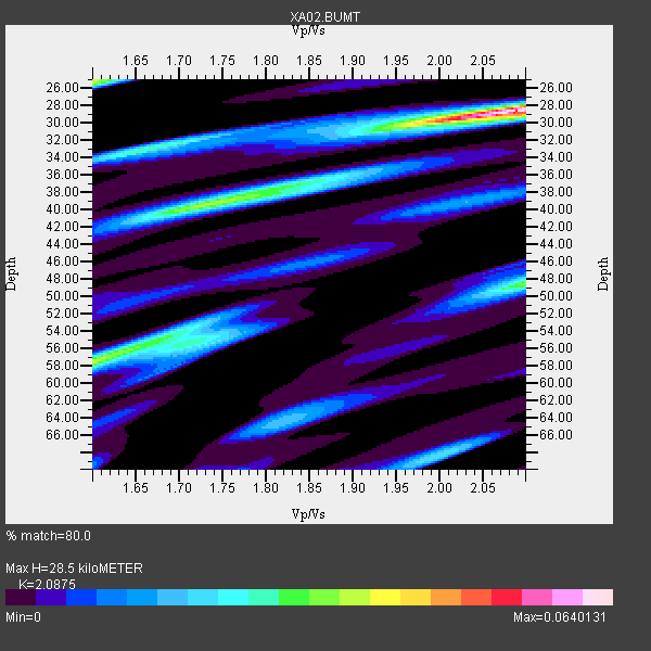
| Crust2 Type: | R2,orogen/65km Bolivia, 0.5 km seds. |
| Thickness Estimate: | 28 km |
| Thickness StdDev: | 5.8 km |
| Vp/Vs Estimate: | 2.09 |
| Vp/Vs StdDev: | 0.15 |
| Vs Estimate: | 3.105 km/s |
| Poisson's Ratio: | 0.35 |
| Peak Value: | 0.06 |
| Assumed Vp: | 6.481 km/s |
| Ps Weight: | 0.33333334 |
| PpPs Weight: | 0.33333334 |
| PsPs Weight: | 0.33333328 |
| Residual Complexity: | 0.716 |
| Nearby stations H: | +- |
| (2.0 deg) Vp/Vs: | +- |
0 with match > 90% ( 0.0 %) and 4 with match > 80% ( 30.76923 %) out of 13.
Download stack as xyz text file.
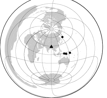
Azimuth Distribution of Events:
Prior Results for this Station
| Study | Thickness | Vp/Vs | Vp | Vs | Poissons Ratio | Extra |
| EARS | 28 km | 2.09 | 6.481 km/s | 3.105 km/s | 0.35 | |
| Crust2.0 | 65 km | 1.76 | 6.481 km/s | 3.685 km/s | 0.26 | R2,orogen/65km Bolivia, 0.5 km seds. |
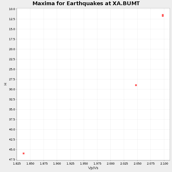
| Global Maxima | 28 km | 2.09 | 6.481 km/s | 3.105 km/s | 0.35 | amp=0.0640131 |
| Local Maxima 1 | 25 km | 1.60 | 6.481 km/s | 4.05 km/s | 0.18 | amp=0.037340503 |
| Local Maxima 2 | 58 km | 1.60 | 6.481 km/s | 4.05 km/s | 0.18 | amp=0.036989633 |
| Local Maxima 3 | 40 km | 1.72 | 6.481 km/s | 3.768 km/s | 0.24 | amp=0.03421157 |
| Local Maxima 4 | 48 km | 2.09 | 6.481 km/s | 3.097 km/s | 0.35 | amp=0.026146771 |
| Predicted Arrivals for vertical incidence (zero ray parameter) | |
| Ps | 4.78 SECOND |
| PpPs | 13.58 SECOND |
| PsPs/PpSs | 18.36 SECOND |
Events Processed for this Station
Download zip of receiver functions as SAC
Plot maxima for each earthquake.
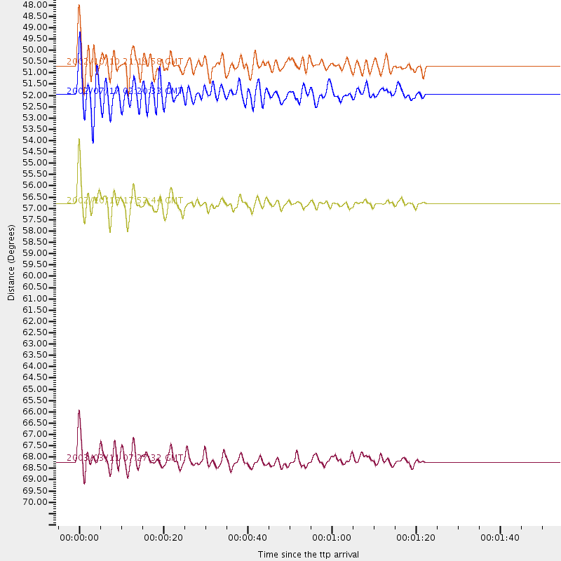
Events Used in the Stack
(4 events)| Radial Match | Distance | Baz | FERegion | Time | Lat/Lon | Depth | Magnitude |
| 84.740486 | 50.7 deg | 117.501 deg | Irian Jaya Region, Indonesia | 2002/10/10 21:19:58 GMT | (-1.5, 134.1) | 10 km | 5.8 MB, 5.7 MS, 6.0 MW |
| 84.325874 | 56.8 deg | 115.006 deg | Irian Jaya, Indonesia | 2002/10/17 17:52:44 GMT | (-3.6, 140.2) | 33 km | 5.6 MB, 6.2 MS, 6.3 MW, 6.3 MW |
| 82.898346 | 68.2 deg | 107.819 deg | New Ireland Region, P.N.G. | 2003/03/11 07:27:32 GMT | (-4.7, 153.2) | 40 km | 6.0 MB, 6.8 MS, 6.8 MW, 6.6 MW |
| 81.47005 | 52.0 deg | 48.49 deg | Kuril Islands | 2002/07/17 02:20:33 GMT | (48.5, 153.3) | 148 km | 5.3 MB, 5.6 MW, 5.6 MW |
Losers
(9 events)| Radial Match | Distance | Baz | FERegion | Time | Lat/Lon | Depth | Magnitude | Reason |
| 83.792786 | 52.9 deg | 119.009 deg | Irian Jaya Region, Indonesia | 2002/12/11 03:49:40 GMT | (-3.8, 135.1) | 10 km | 5.8 MB, 6.0 MS, 6.3 MW, 6.3 MW | |
| 79.619774 | 51.8 deg | 125.275 deg | Banda Sea | 2003/03/09 10:36:23 GMT | (-6.8, 131.0) | 46 km | 5.9 MB, 5.4 MS, 5.9 MW, 5.9 MW | |
| 78.1131 | 53.1 deg | 117.974 deg | Irian Jaya Region, Indonesia | 2002/08/24 20:21:29 GMT | (-3.3, 135.8) | 33 km | 5.5 MB, 5.5 MS, 5.8 MW, 5.7 MW | |
| 73.09237 | 42.2 deg | 75.853 deg | Southeast Of Honshu, Japan | 2002/08/02 23:11:39 GMT | (29.3, 139.0) | 426 km | 5.5 MB, 6.3 MW, 6.3 MW | |
| 68.30521 | 51.1 deg | 125.569 deg | Banda Sea | 2002/07/30 20:02:06 GMT | (-6.5, 130.3) | 103 km | 5.5 MW, 5.4 MB, 5.3 MW | |
| 64.05188 | 35.6 deg | 50.523 deg | Northeastern China | 2002/09/15 08:39:32 GMT | (44.8, 129.9) | 586 km | 5.8 MB, 6.4 MW, 6.4 MW | |
| 57.326714 | 66.1 deg | 254.358 deg | Lake Tanganyika Region | 2002/10/24 06:08:37 GMT | (-1.9, 29.0) | 11 km | 5.9 MB, 6.3 MS, 6.2 MW, 6.1 MW | |
| 53.654648 | 48.0 deg | 130.575 deg | Banda Sea | 2002/12/17 16:09:12 GMT | (-7.0, 125.4) | 493 km | 5.8 MW, 5.4 MB, 5.7 MW | |
| 23.864342 | 75.2 deg | 39.513 deg | Fox Islands, Aleutian Islands | 2002/12/28 09:36:08 GMT | (51.4, -168.5) | 10 km | 5.8 MB, 4.9 MS, 5.8 MW, 5.5 MW |
