
Station XA PARO - Paro Bhutan PASSCAL
Network: XA02 - Bhutan
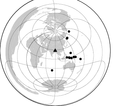
Nearby stations (2 deg radius)
| Station | Name | (Lat, Lon) | Start / End | Elevation |
| PARO | Paro Bhutan PASSCAL | (27.57, 89.32) | 2002-01-15 / 2003-12-31 | 2566 m |
| Crust2 Type: | RE,orogen/60km Tibet, 2.5 km seds. |
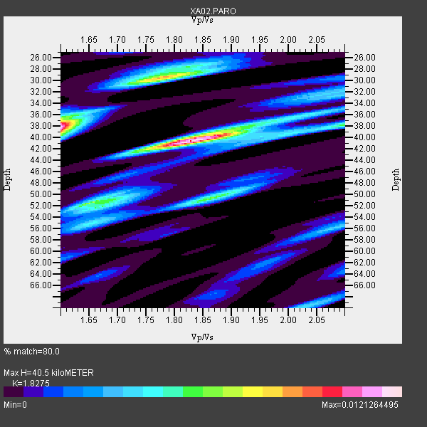
| Thickness Estimate: | 40 km |
| Thickness StdDev: | 5.4 km |
| Vp/Vs Estimate: | 1.83 |
| Vp/Vs StdDev: | 0.15 |
| Vs Estimate: | 3.494 km/s |
| Poisson's Ratio: | 0.29 |
| Peak Value: | 0.01 |
| Assumed Vp: | 6.385 km/s |
| Ps Weight: | 0.33333334 |
| PpPs Weight: | 0.33333334 |
| PsPs Weight: | 0.33333328 |
| Residual Complexity: | 0.755 |
| Nearby stations H: | +- |
| (2.0 deg) Vp/Vs: | +- |
1 with match > 90% ( 5.0 %) and 14 with match > 80% ( 70.0 %) out of 20.
Download stack as xyz text file.
Azimuth Distribution of Events:
Prior Results for this Station
| Study | Thickness | Vp/Vs | Vp | Vs | Poissons Ratio | Extra |
| EARS | 40 km | 1.83 | 6.385 km/s | 3.494 km/s | 0.29 | |
| Crust2.0 | 60 km | 1.76 | 6.385 km/s | 3.623 km/s | 0.26 | RE,orogen/60km Tibet, 2.5 km seds. |
| Global Maxima | 40 km | 1.83 | 6.385 km/s | 3.494 km/s | 0.29 | amp=0.0121264495 |
| Local Maxima 1 | 38 km | 1.60 | 6.385 km/s | 3.991 km/s | 0.18 | amp=0.011663362 |
| Local Maxima 2 | 29 km | 1.78 | 6.385 km/s | 3.582 km/s | 0.27 | amp=0.008240148 |
| Local Maxima 3 | 50 km | 1.87 | 6.385 km/s | 3.424 km/s | 0.30 | amp=0.00633015 |
| Local Maxima 4 | 51 km | 1.68 | 6.385 km/s | 3.801 km/s | 0.23 | amp=0.0055205645 |
| Predicted Arrivals for vertical incidence (zero ray parameter) | |
| Ps | 5.25 SECOND |
| PpPs | 17.93 SECOND |
| PsPs/PpSs | 23.18 SECOND |
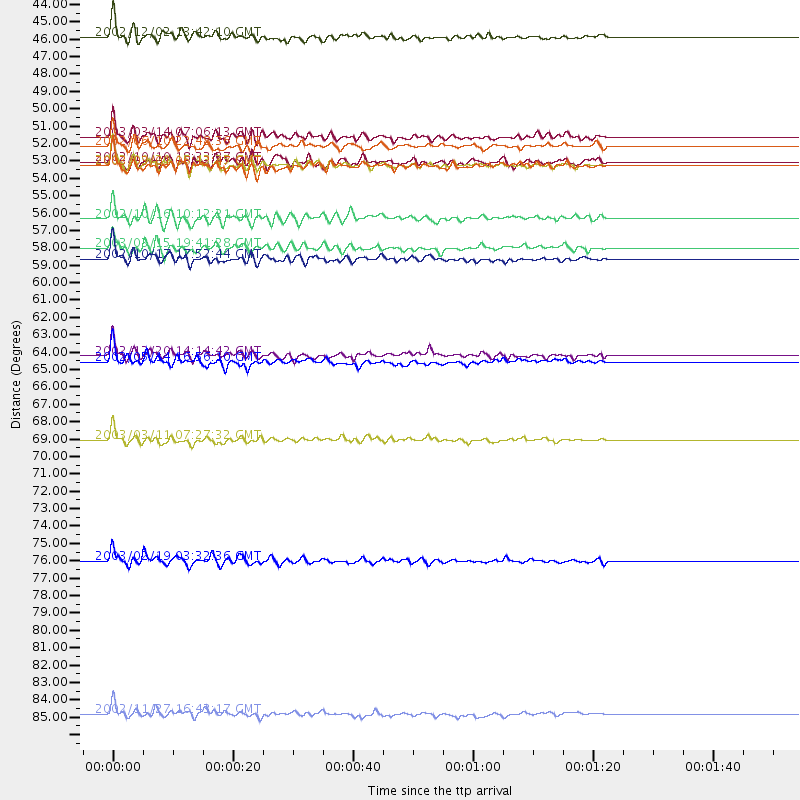
Events Processed for this Station
Download zip of receiver functions as SAC
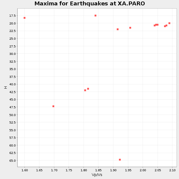
Plot maxima for each earthquake.
Events Used in the Stack
(14 events)| Radial Match | Distance | Baz | FERegion | Time | Lat/Lon | Depth | Magnitude |
| 91.29402 | 52.0 deg | 116.49 deg | Irian Jaya Region, Indonesia | 2002/09/20 15:43:35 GMT | (-1.7, 134.2) | 10 km | 5.9 MB, 6.4 MS, 6.4 MW, 6.3 MW |
| 89.18993 | 77.1 deg | 35.952 deg | Unimak Island Region, Alaska | 2003/02/19 03:32:36 GMT | (53.6, -164.6) | 19 km | 5.8 MB, 6.6 MS, 6.6 MW, 6.6 MW |
| 89.04554 | 64.1 deg | 108.585 deg | Bismarck Sea | 2002/12/20 14:14:42 GMT | (-3.1, 147.9) | 33 km | 5.8 MB, 6.4 MS, 6.3 MW, 6.3 MW |
| 88.86698 | 86.7 deg | 108.064 deg | Vanuatu Islands | 2002/11/27 16:43:17 GMT | (-14.5, 167.8) | 33 km | 5.6 MB, 5.8 MS, 5.9 MW, 5.8 MW |
| 88.56201 | 58.0 deg | 114.011 deg | Irian Jaya, Indonesia | 2002/10/17 17:52:44 GMT | (-3.6, 140.2) | 33 km | 5.6 MB, 6.2 MS, 6.3 MW, 6.3 MW |
| 87.97042 | 50.3 deg | 116.195 deg | Irian Jaya Region, Indonesia | 2003/03/14 07:06:13 GMT | (-0.4, 133.0) | 33 km | 6.0 MB, 6.1 MS, 6.3 MW, 6.3 MW |
| 86.326126 | 52.1 deg | 116.449 deg | Irian Jaya Region, Indonesia | 2003/03/01 06:12:47 GMT | (-1.7, 134.3) | 28 km | 5.5 MB, 5.7 MS, 6.0 MW, 5.9 MW |
| 86.13375 | 43.9 deg | 119.715 deg | Northern Molucca Sea | 2002/12/02 13:42:10 GMT | (1.5, 126.4) | 10 km | 5.7 MB, 5.6 MS, 6.0 MW, 5.9 MW |
| 85.62551 | 64.5 deg | 189.262 deg | Mid-Indian Ridge | 2002/05/14 16:56:10 GMT | (-36.5, 78.9) | 10 km | 5.6 MB, 6.1 MS, 6.3 MW, 6.1 MW |
| 83.802536 | 69.4 deg | 107.012 deg | New Ireland Region, P.N.G. | 2003/03/11 07:27:32 GMT | (-4.7, 153.2) | 40 km | 6.0 MB, 6.8 MS, 6.8 MW, 6.6 MW |
| 83.10898 | 50.9 deg | 98.463 deg | W. Caroline Islands, Micronesia | 2002/06/10 22:48:36 GMT | (11.0, 140.7) | 33 km | 5.9 MB, 5.9 MS, 6.1 MW, 6.0 MW |
| 82.6612 | 57.3 deg | 43.711 deg | Off East Coast Of Kamchatka | 2003/03/15 19:41:28 GMT | (52.2, 160.4) | 30 km | 5.6 MB, 5.8 MS, 6.0 MW, 6.0 MW |
| 80.52838 | 55.4 deg | 44.176 deg | Near East Coast Of Kamchatka | 2002/10/16 10:12:21 GMT | (52.0, 157.3) | 102 km | 6.1 MB, 6.2 MW, 6.2 MW |
| 80.29343 | 51.9 deg | 116.37 deg | Irian Jaya Region, Indonesia | 2002/10/10 18:33:37 GMT | (-1.5, 134.1) | 10 km | 5.5 MS, 5.4 MB |
Losers
(6 events)| Radial Match | Distance | Baz | FERegion | Time | Lat/Lon | Depth | Magnitude | Reason |
| 86.6621 | 48.2 deg | 49.246 deg | Northwest Of Kuril Islands | 2002/11/17 04:53:53 GMT | (47.8, 146.2) | 459 km | 7.3 MW, 7.3 MW | |
| 79.35546 | 43.4 deg | 75.55 deg | Southeast Of Honshu, Japan | 2002/08/02 23:11:39 GMT | (29.3, 139.0) | 426 km | 5.5 MB, 6.3 MW, 6.3 MW | |
| 76.3807 | 35.8 deg | 108.386 deg | Luzon, Philippines | 2003/02/15 05:47:58 GMT | (12.2, 123.9) | 10 km | 5.6 MS, 5.4 MB, 5.8 MW, 5.8 MW | |
| 75.48988 | 44.9 deg | 61.485 deg | Near East Coast Of Honshu, Japan | 2002/11/03 03:37:42 GMT | (38.9, 142.0) | 39 km | 5.7 MB, 6.1 MS, 6.4 MW, 6.4 MW | |
| 73.36913 | 52.9 deg | 48.49 deg | Kuril Islands | 2002/07/17 02:20:33 GMT | (48.5, 153.3) | 148 km | 5.3 MB, 5.6 MW, 5.6 MW | |
| 53.634117 | 89.7 deg | 111.611 deg | Vanuatu Islands | 2002/05/07 15:16:06 GMT | (-19.0, 168.7) | 33 km | 5.6 MB, 5.4 MS, 5.9 MW, 5.9 MW |
