
Station XA SA07 - XA.SA07
Network: XA97 - Anatomy of an Archean Craton, South Africa
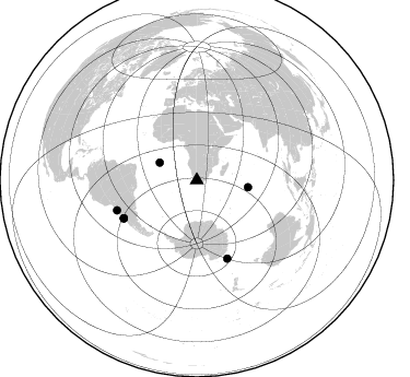
Nearby stations (2 deg radius)
| Station | Name | (Lat, Lon) | Start / End | Elevation |
| SA07 | XA.SA07 | (-31.98, 20.23) | 1997-05-07 / 1999-12-31 | 1277 m |
| Crust2 Type: | I7,late Proter., 1 km seds. |
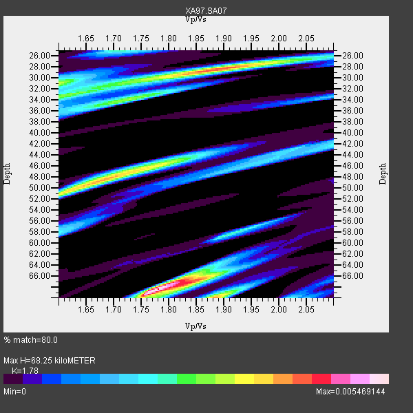
| Thickness Estimate: | 68 km |
| Thickness StdDev: | 17 km |
| Vp/Vs Estimate: | 1.78 |
| Vp/Vs StdDev: | 0.11 |
| Vs Estimate: | 3.715 km/s |
| Poisson's Ratio: | 0.27 |
| Peak Value: | 0.01 |
| Assumed Vp: | 6.612 km/s |
| Ps Weight: | 0.33333334 |
| PpPs Weight: | 0.33333334 |
| PsPs Weight: | 0.33333328 |
| Residual Complexity: | 0.878 |
| Nearby stations H: | +- |
| (2.0 deg) Vp/Vs: | +- |
3 with match > 90% ( 16.666666 %) and 6 with match > 80% ( 33.333332 %) out of 18.
Download stack as xyz text file.
Azimuth Distribution of Events:
Prior Results for this Station
| Study | Thickness | Vp/Vs | Vp | Vs | Poissons Ratio | Extra |
| EARS | 68 km | 1.78 | 6.612 km/s | 3.715 km/s | 0.27 | |
| Crust2.0 | 42 km | 1.78 | 6.612 km/s | 3.71 km/s | 0.27 | I7,late Proter., 1 km seds. |
| Global Maxima | 68 km | 1.78 | 6.612 km/s | 3.715 km/s | 0.27 | amp=0.005469144 |
| Local Maxima 1 | 28 km | 1.88 | 6.612 km/s | 3.522 km/s | 0.30 | amp=0.0042986493 |
| Local Maxima 2 | 70 km | 1.88 | 6.612 km/s | 3.512 km/s | 0.30 | amp=0.0040354203 |
| Local Maxima 3 | 49 km | 1.67 | 6.612 km/s | 3.959 km/s | 0.22 | amp=0.003915617 |
| Local Maxima 4 | 30 km | 1.60 | 6.612 km/s | 4.132 km/s | 0.18 | amp=0.002685249 |
| Predicted Arrivals for vertical incidence (zero ray parameter) | |
| Ps | 8.05 SECOND |
| PpPs | 28.70 SECOND |
| PsPs/PpSs | 36.75 SECOND |
Events Processed for this Station
Download zip of receiver functions as SAC
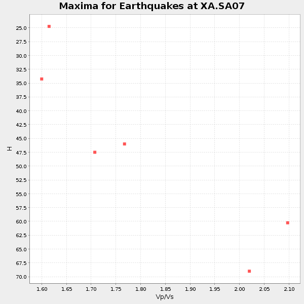
Plot maxima for each earthquake.
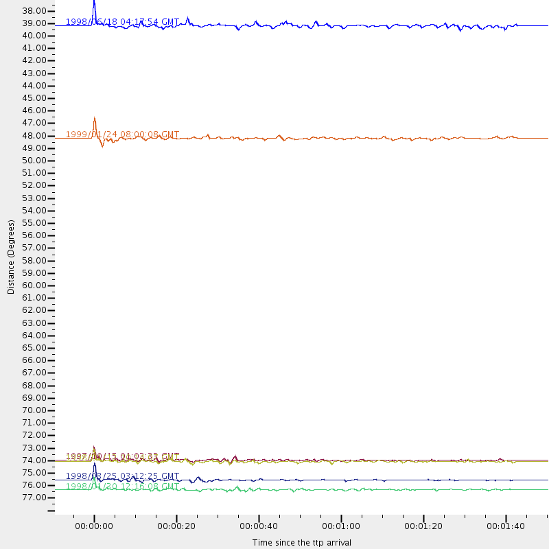
Events Used in the Stack
(6 events)| Radial Match | Distance | Baz | FERegion | Time | Lat/Lon | Depth | Magnitude |
| 98.38335 | 77.2 deg | 158.671 deg | Balleny Islands Region | 1998/03/25 03:12:25 GMT | (-62.9, 149.5) | 10 km | 6.6 MB, 8.0 MS, 8.3 UNKNOWN, 8.1 MW |
| 95.39587 | 75.5 deg | 242.555 deg | Near Coast Of Central Chile | 1997/10/15 01:03:33 GMT | (-30.9, -71.2) | 58 km | 6.8 MB, 6.8 MS, 7.3 UNKNOWN, 7.1 MW |
| 93.839584 | 78.1 deg | 249.278 deg | Near Coast Of Northern Chile | 1998/01/30 12:16:08 GMT | (-23.9, -70.2) | 42 km | 6.3 MB, 6.5 MS, 7.0 UNKNOWN, 6.7 ME |
| 89.42616 | 75.6 deg | 242.427 deg | Near Coast Of Central Chile | 1998/01/12 10:14:07 GMT | (-31.0, -71.4) | 35 km | 5.8 MB, 6.2 MS, 6.6 UNKNOWN, 6.2 ME |
| 83.829575 | 47.3 deg | 97.877 deg | Mid-Indian Ridge | 1999/01/24 08:00:08 GMT | (-26.5, 74.5) | 10 km | 6.0 MB, 6.3 MS, 6.3 MW, 6.3 ME |
| 83.39899 | 37.4 deg | 295.158 deg | Ascension Island Region | 1998/06/18 04:17:54 GMT | (-11.6, -13.9) | 10 km | 6.1 MS, 5.4 MB, 6.2 UNKNOWN |
Losers
(12 events)| Radial Match | Distance | Baz | FERegion | Time | Lat/Lon | Depth | Magnitude | Reason |
| 75.24236 | 74.8 deg | 241.277 deg | Near Coast Of Central Chile | 1998/07/29 07:14:24 GMT | (-32.3, -71.3) | 51 km | 6.3 MB, 6.5 UNKNOWN, 6.5 ME | |
| 74.59822 | 31.3 deg | 249.724 deg | Southern Mid-Atlantic Ridge | 1998/06/24 10:44:30 GMT | (-37.3, -17.4) | 10 km | 5.7 MB, 5.8 MS, 6.0 UNKNOWN, 5.9 MW | |
| 72.949905 | 81.0 deg | 153.574 deg | West Of Macquarie Island | 1998/08/04 15:51:01 GMT | (-56.7, 147.4) | 10 km | 5.5 MS, 5.3 MB | |
| 67.1342 | 81.7 deg | 92.098 deg | Sunda Strait, Indonesia | 1999/02/03 06:35:56 GMT | (-6.2, 104.2) | 33 km | 5.6 MB, 5.6 MS, 5.8 MW, 5.7 MW | |
| 67.05752 | 71.9 deg | 235.927 deg | S. Chile-Argentina Border Region | 1998/12/14 16:25:24 GMT | (-38.2, -71.0) | 138 km | 6.0 UNKNOWN, 4.8 MS, 5.4 MB | |
| 64.45651 | 69.5 deg | 34.431 deg | Southern Iran | 1999/03/04 05:47:49 GMT | (28.3, 57.1) | 33 km | 5.6 MB | |
| 63.30669 | 80.7 deg | 78.965 deg | Northern Sumatra, Indonesia | 1997/08/20 07:15:15 GMT | (4.4, 96.5) | 33 km | 5.9 MB, 6.0 MS, 6.1 UNKNOWN, 6.0 MW | |
| 59.91481 | 40.5 deg | 219.802 deg | South Sandwich Islands Region | 1998/08/29 08:30:21 GMT | (-55.7, -27.0) | 33 km | 5.6 MB, 5.6 MS, 6.0 UNKNOWN, 5.9 MW | |
| 59.747547 | 82.0 deg | 258.835 deg | Peru-Bolivia Border Region | 1997/11/28 22:53:41 GMT | (-13.7, -68.8) | 586 km | 6.4 MB, 6.6 UNKNOWN, 6.6 MW | |
| 56.59729 | 87.5 deg | 95.112 deg | Java Sea | 1997/07/11 09:55:12 GMT | (-5.7, 110.8) | 574 km | 5.6 MB | |
| 55.945366 | 30.4 deg | 253.359 deg | Southern Mid-Atlantic Ridge | 1998/01/03 06:10:08 GMT | (-35.5, -16.2) | 10 km | 5.9 MS, 5.4 MB, 6.3 UNKNOWN, 6.1 MW | |
| 55.54983 | 79.5 deg | 78.566 deg | Northern Sumatra, Indonesia | 1999/02/04 19:28:00 GMT | (4.0, 95.3) | 56 km | 5.8 MB, 5.4 MS, 5.9 MW, 5.9 MW |
