
Station XA SA09 - XA.SA09
Network: XA97 - Anatomy of an Archean Craton, South Africa
Nearby stations (2 deg radius)
| Station | Name | (Lat, Lon) | Start / End | Elevation |
| SA09 | XA.SA09 | (-30.92, 22.99) | 1998-04-23 / 1999-12-31 | 1200 m |
| Crust2 Type: | I2,late Proter., 1 km seds. |
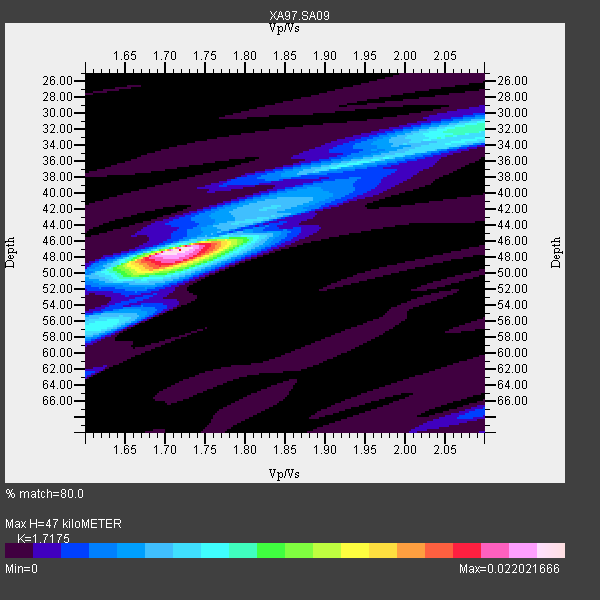
| Thickness Estimate: | 47 km |
| Thickness StdDev: | 7.4 km |
| Vp/Vs Estimate: | 1.72 |
| Vp/Vs StdDev: | 0.15 |
| Vs Estimate: | 3.829 km/s |
| Poisson's Ratio: | 0.24 |
| Peak Value: | 0.02 |
| Assumed Vp: | 6.576 km/s |
| Ps Weight: | 0.33333334 |
| PpPs Weight: | 0.33333334 |
| PsPs Weight: | 0.33333328 |
| Residual Complexity: | 0.570 |
| Nearby stations H: | +- |
| (2.0 deg) Vp/Vs: | +- |
1 with match > 90% ( 10.0 %) and 5 with match > 80% ( 50.0 %) out of 10.
Download stack as xyz text file.
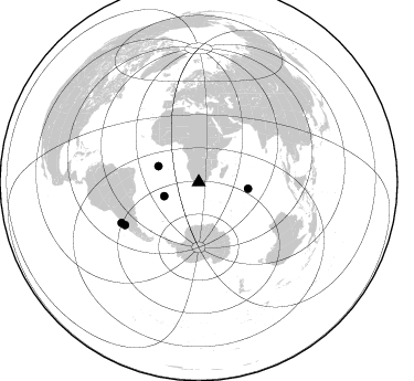
Azimuth Distribution of Events:
Prior Results for this Station
| Study | Thickness | Vp/Vs | Vp | Vs | Poissons Ratio | Extra |
| EARS | 47 km | 1.72 | 6.576 km/s | 3.829 km/s | 0.24 | |
| Crust2.0 | 38 km | 1.78 | 6.576 km/s | 3.695 km/s | 0.27 | I2,late Proter., 1 km seds. |
| Global Maxima | 47 km | 1.72 | 6.576 km/s | 3.829 km/s | 0.24 | amp=0.022021666 |
| Local Maxima 1 | 48 km | 1.71 | 6.576 km/s | 3.84 km/s | 0.24 | amp=0.012596317 |
| Local Maxima 2 | 32 km | 2.10 | 6.576 km/s | 3.139 km/s | 0.35 | amp=0.008887715 |
| Local Maxima 3 | 36 km | 1.92 | 6.576 km/s | 3.421 km/s | 0.31 | amp=0.006121058 |
| Local Maxima 4 | 33 km | 2.10 | 6.576 km/s | 3.135 km/s | 0.35 | amp=0.004691639 |
| Predicted Arrivals for vertical incidence (zero ray parameter) | |
| Ps | 5.13 SECOND |
| PpPs | 19.42 SECOND |
| PsPs/PpSs | 24.55 SECOND |
Events Processed for this Station
Download zip of receiver functions as SAC
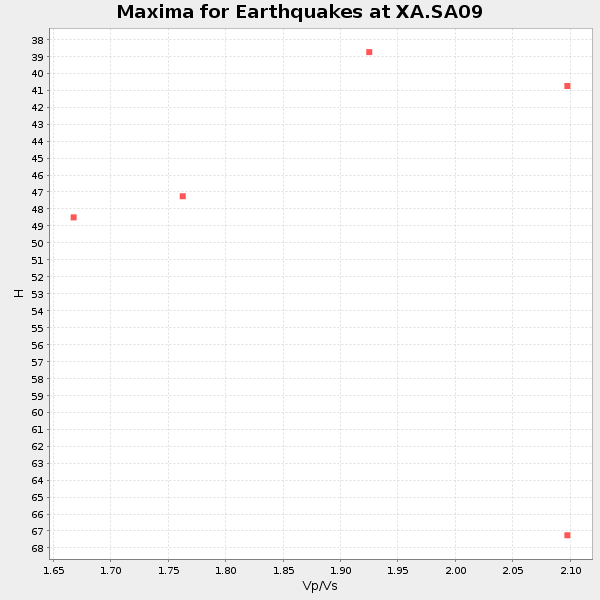
Plot maxima for each earthquake.
Events Used in the Stack
(5 events)| Radial Match | Distance | Baz | FERegion | Time | Lat/Lon | Depth | Magnitude |
| 92.078865 | 45.1 deg | 97.753 deg | Mid-Indian Ridge | 1999/01/24 08:00:08 GMT | (-26.5, 74.5) | 10 km | 6.0 MB, 6.3 MS, 6.3 MW, 6.3 ME |
| 88.28218 | 77.4 deg | 239.904 deg | Near Coast Of Central Chile | 1998/07/29 07:14:24 GMT | (-32.3, -71.3) | 51 km | 6.3 MB, 6.5 UNKNOWN, 6.5 ME |
| 81.29203 | 39.1 deg | 291.32 deg | Ascension Island Region | 1998/06/18 04:17:54 GMT | (-11.6, -13.9) | 10 km | 6.1 MS, 5.4 MB, 6.2 UNKNOWN |
| 80.73522 | 79.1 deg | 242.271 deg | Near Coast Of Central Chile | 1998/09/03 17:37:58 GMT | (-29.5, -71.7) | 27 km | 6.2 MB, 6.6 MS, 6.5 UNKNOWN, 6.4 ME |
| 80.467514 | 33.8 deg | 248.083 deg | Southern Mid-Atlantic Ridge | 1998/06/24 10:44:30 GMT | (-37.3, -17.4) | 10 km | 5.7 MB, 5.8 MS, 6.0 UNKNOWN, 5.9 MW |
Losers
(5 events)| Radial Match | Distance | Baz | FERegion | Time | Lat/Lon | Depth | Magnitude | Reason |
| 68.99199 | 95.8 deg | 93.207 deg | Minahassa Peninsula, Sulawesi | 1998/05/21 05:34:25 GMT | (0.2, 119.6) | 33 km | 6.2 MB, 6.3 MS, 6.6 UNKNOWN, 6.6 MW | |
| 67.72685 | 85.4 deg | 96.719 deg | Java, Indonesia | 1998/09/28 13:34:30 GMT | (-8.2, 112.4) | 152 km | 6.4 MB, 6.5 UNKNOWN, 6.5 MW | |
| 59.78097 | 74.5 deg | 234.638 deg | S. Chile-Argentina Border Region | 1998/12/14 16:25:24 GMT | (-38.2, -71.0) | 138 km | 6.0 UNKNOWN, 4.8 MS, 5.4 MB | |
| 54.2987 | 42.8 deg | 219.654 deg | South Sandwich Islands Region | 1998/08/29 08:30:21 GMT | (-55.7, -27.0) | 33 km | 5.6 MB, 5.6 MS, 6.0 UNKNOWN, 5.9 MW | |
| 48.07239 | 77.0 deg | 77.244 deg | Northern Sumatra, Indonesia | 1999/02/04 19:28:00 GMT | (4.0, 95.3) | 56 km | 5.8 MB, 5.4 MS, 5.9 MW, 5.9 MW |
