
Station XA SA10 - XA.SA10
Network: XA97 - Anatomy of an Archean Craton, South Africa
Nearby stations (2 deg radius)
| Station | Name | (Lat, Lon) | Start / End | Elevation |
| SA10 | XA.SA10 | (-30.97, 23.91) | 1998-07-18 / 1999-12-31 | 1400 m |
| Crust2 Type: | I2,late Proter., 1 km seds. |
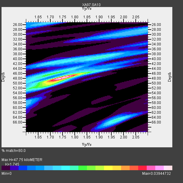
| Thickness Estimate: | 48 km |
| Thickness StdDev: | 2.9 km |
| Vp/Vs Estimate: | 1.75 |
| Vp/Vs StdDev: | 0.01 |
| Vs Estimate: | 3.769 km/s |
| Poisson's Ratio: | 0.26 |
| Peak Value: | 0.04 |
| Assumed Vp: | 6.576 km/s |
| Ps Weight: | 0.33333334 |
| PpPs Weight: | 0.33333334 |
| PsPs Weight: | 0.33333328 |
| Residual Complexity: | 0.663 |
| Nearby stations H: | +- |
| (2.0 deg) Vp/Vs: | +- |
2 with match > 90% ( 28.571428 %) and 2 with match > 80% ( 28.571428 %) out of 7.
Download stack as xyz text file.
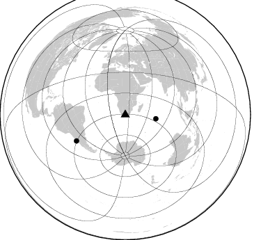
Azimuth Distribution of Events:
Prior Results for this Station
| Study | Thickness | Vp/Vs | Vp | Vs | Poissons Ratio | Extra |
| EARS | 48 km | 1.75 | 6.576 km/s | 3.769 km/s | 0.26 | |
| Crust2.0 | 38 km | 1.78 | 6.576 km/s | 3.695 km/s | 0.27 | I2,late Proter., 1 km seds. |
| Global Maxima | 48 km | 1.75 | 6.576 km/s | 3.769 km/s | 0.26 | amp=0.03944732 |
| Local Maxima 1 | 47 km | 1.68 | 6.576 km/s | 3.926 km/s | 0.22 | amp=0.017249422 |
| Local Maxima 2 | 65 km | 1.97 | 6.576 km/s | 3.338 km/s | 0.33 | amp=0.01680933 |
| Local Maxima 3 | 51 km | 1.68 | 6.576 km/s | 3.914 km/s | 0.23 | amp=0.014236789 |
| Local Maxima 4 | 42 km | 1.70 | 6.576 km/s | 3.88 km/s | 0.23 | amp=0.013465806 |
| Predicted Arrivals for vertical incidence (zero ray parameter) | |
| Ps | 5.41 SECOND |
| PpPs | 19.93 SECOND |
| PsPs/PpSs | 25.34 SECOND |
Events Processed for this Station
Download zip of receiver functions as SAC
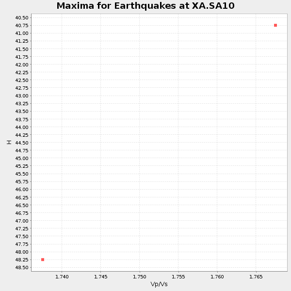
Plot maxima for each earthquake.
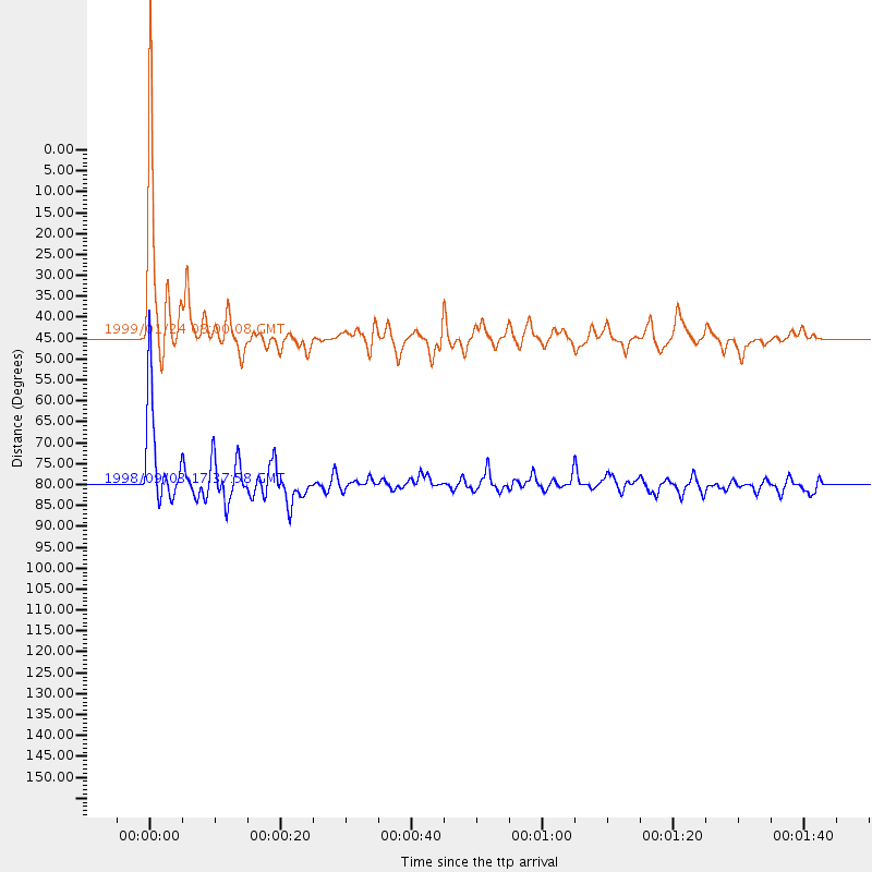
Events Used in the Stack
(2 events)| Radial Match | Distance | Baz | FERegion | Time | Lat/Lon | Depth | Magnitude |
| 94.09221 | 44.3 deg | 97.334 deg | Mid-Indian Ridge | 1999/01/24 08:00:08 GMT | (-26.5, 74.5) | 10 km | 6.0 MB, 6.3 MS, 6.3 MW, 6.3 ME |
| 92.40167 | 79.8 deg | 241.874 deg | Near Coast Of Central Chile | 1998/09/03 17:37:58 GMT | (-29.5, -71.7) | 27 km | 6.2 MB, 6.6 MS, 6.5 UNKNOWN, 6.4 ME |
Losers
(5 events)| Radial Match | Distance | Baz | FERegion | Time | Lat/Lon | Depth | Magnitude | Reason |
| 79.265144 | 91.7 deg | 187.343 deg | Pacific-Antarctic Ridge | 1998/10/11 23:36:22 GMT | (-56.9, -142.6) | 10 km | 5.2 MB, 5.7 MS, 6.3 UNKNOWN, 6.2 MW | |
| 74.71807 | 78.1 deg | 239.526 deg | Near Coast Of Central Chile | 1998/07/29 07:14:24 GMT | (-32.3, -71.3) | 51 km | 6.3 MB, 6.5 UNKNOWN, 6.5 ME | |
| 65.49821 | 66.9 deg | 31.677 deg | Southern Iran | 1999/03/04 05:47:49 GMT | (28.3, 57.1) | 33 km | 5.6 MB | |
| 51.377846 | 75.1 deg | 234.301 deg | S. Chile-Argentina Border Region | 1998/12/14 16:25:24 GMT | (-38.2, -71.0) | 138 km | 6.0 UNKNOWN, 4.8 MS, 5.4 MB | |
| 48.999897 | 94.9 deg | 92.718 deg | Minahassa Peninsula, Sulawesi | 1999/02/23 07:27:56 GMT | (0.2, 119.5) | 33 km | 5.6 MB, 5.8 MS |
