
Station XA SA11 - XA.SA11
Network: XA97 - Anatomy of an Archean Craton, South Africa
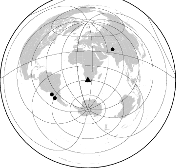
Nearby stations (2 deg radius)
| Station | Name | (Lat, Lon) | Start / End | Elevation |
| SA11 | XA.SA11 | (-29.97, 20.95) | 1997-04-21 / 1999-12-31 | 1066 m |
| Crust2 Type: | I1,late Proter., no seds. |
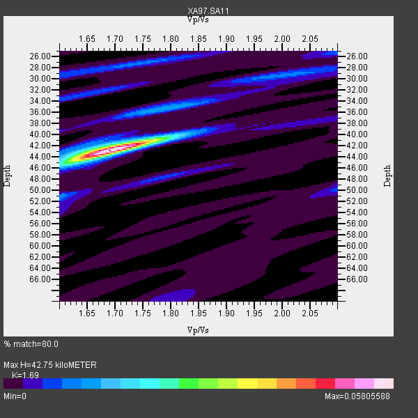
| Thickness Estimate: | 43 km |
| Thickness StdDev: | 0.2 km |
| Vp/Vs Estimate: | 1.69 |
| Vp/Vs StdDev: | 0.01 |
| Vs Estimate: | 3.93 km/s |
| Poisson's Ratio: | 0.23 |
| Peak Value: | 0.06 |
| Assumed Vp: | 6.642 km/s |
| Ps Weight: | 0.33333334 |
| PpPs Weight: | 0.33333334 |
| PsPs Weight: | 0.33333328 |
| Residual Complexity: | 0.337 |
| Nearby stations H: | +- |
| (2.0 deg) Vp/Vs: | +- |
2 with match > 90% ( 12.5 %) and 4 with match > 80% ( 25.0 %) out of 16.
Download stack as xyz text file.
Azimuth Distribution of Events:
Prior Results for this Station
| Study | Thickness | Vp/Vs | Vp | Vs | Poissons Ratio | Extra |
| EARS | 43 km | 1.69 | 6.642 km/s | 3.93 km/s | 0.23 | |
| Crust2.0 | 43 km | 1.77 | 6.642 km/s | 3.756 km/s | 0.26 | I1,late Proter., no seds. |
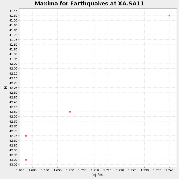
| Global Maxima | 43 km | 1.69 | 6.642 km/s | 3.93 km/s | 0.23 | amp=0.05805588 |
| Local Maxima 1 | 35 km | 1.79 | 6.642 km/s | 3.721 km/s | 0.27 | amp=0.013448828 |
| Local Maxima 2 | 29 km | 2.00 | 6.642 km/s | 3.329 km/s | 0.33 | amp=0.009624794 |
| Local Maxima 3 | 27 km | 1.74 | 6.642 km/s | 3.828 km/s | 0.25 | amp=0.009429238 |
| Local Maxima 4 | 52 km | 1.60 | 6.642 km/s | 4.151 km/s | 0.18 | amp=0.0072282325 |
| Predicted Arrivals for vertical incidence (zero ray parameter) | |
| Ps | 4.44 SECOND |
| PpPs | 17.31 SECOND |
| PsPs/PpSs | 21.76 SECOND |
Events Processed for this Station
Download zip of receiver functions as SAC
Plot maxima for each earthquake.
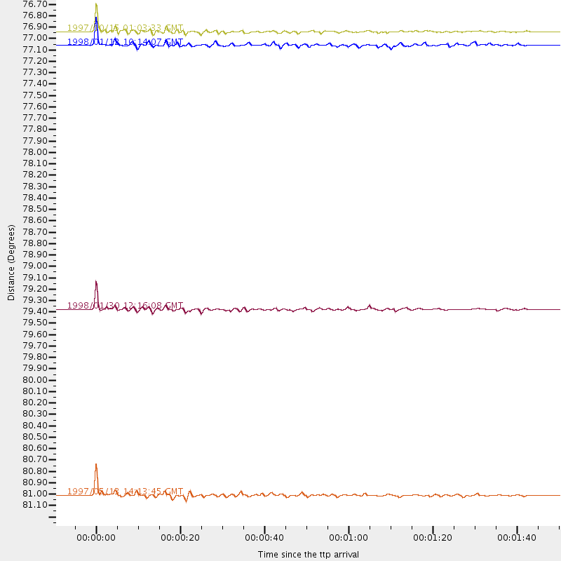
Events Used in the Stack
(4 events)| Radial Match | Distance | Baz | FERegion | Time | Lat/Lon | Depth | Magnitude |
| 97.45363 | 76.9 deg | 241.821 deg | Near Coast Of Central Chile | 1997/10/15 01:03:33 GMT | (-30.9, -71.2) | 58 km | 6.8 MB, 6.8 MS, 7.3 UNKNOWN, 7.1 MW |
| 95.76743 | 79.4 deg | 248.58 deg | Near Coast Of Northern Chile | 1998/01/30 12:16:08 GMT | (-23.9, -70.2) | 42 km | 6.3 MB, 6.5 MS, 7.0 UNKNOWN, 6.7 ME |
| 88.96506 | 77.1 deg | 241.697 deg | Near Coast Of Central Chile | 1998/01/12 10:14:07 GMT | (-31.0, -71.4) | 35 km | 5.8 MB, 6.2 MS, 6.6 UNKNOWN, 6.2 ME |
| 87.13636 | 81.0 deg | 38.728 deg | Hindu Kush Region, Afghanistan | 1997/05/13 14:13:45 GMT | (36.4, 70.9) | 196 km | 6.1 MB, 6.5 UNKNOWN, 6.4 MW |
Losers
(12 events)| Radial Match | Distance | Baz | FERegion | Time | Lat/Lon | Depth | Magnitude | Reason |
| 99.490944 | 75.3 deg | 231.837 deg | Off Coast Of Southern Chile | 1998/04/01 22:42:56 GMT | (-40.3, -74.9) | 9.0 km | 6.2 MB, 6.0 MS, 6.7 UNKNOWN, 6.6 ME | |
| 79.639366 | 80.9 deg | 38.64 deg | Hindu Kush Region, Afghanistan | 1997/12/17 05:51:29 GMT | (36.4, 70.8) | 207 km | 5.5 MB, 6.3 UNKNOWN | |
| 73.62395 | 97.7 deg | 270.003 deg | Colombia | 1997/09/02 12:13:22 GMT | (3.8, -75.7) | 199 km | 6.5 MB, 6.8 UNKNOWN, 6.4 ME | |
| 71.19678 | 44.9 deg | 302.45 deg | North Of Ascension Island | 1998/04/10 16:40:38 GMT | (-1.3, -15.7) | 10 km | 5.9 MS, 5.4 MB, 6.2 UNKNOWN, 6.1 MW | |
| 67.744064 | 91.0 deg | 61.226 deg | Myanmar | 1997/12/30 13:43:18 GMT | (25.4, 96.6) | 33 km | 5.7 MS, 5.4 MB, 5.7 UNKNOWN, 5.7 MW | |
| 65.18407 | 44.8 deg | 213.521 deg | South Sandwich Islands Region | 1997/10/05 18:04:30 GMT | (-59.7, -29.2) | 274 km | 6.0 MB, 6.3 UNKNOWN, 6.3 MW | |
| 62.424404 | 83.0 deg | 258.225 deg | Peru-Bolivia Border Region | 1997/11/28 22:53:41 GMT | (-13.7, -68.8) | 586 km | 6.4 MB, 6.6 UNKNOWN, 6.6 MW | |
| 58.1517 | 78.1 deg | 243.13 deg | Near Coast Of Central Chile | 1997/07/19 12:22:57 GMT | (-29.3, -71.7) | 26 km | 5.8 MB, 5.5 MS, 5.9 UNKNOWN, 5.8 MW | |
| 57.510323 | 76.6 deg | 251.114 deg | Jujuy Province, Argentina | 1997/07/20 10:14:22 GMT | (-23.0, -66.3) | 256 km | 5.7 MB, 6.1 UNKNOWN, 5.7 ME | |
| 54.680893 | 77.3 deg | 245.956 deg | Northern Chile | 1997/05/17 02:10:18 GMT | (-27.2, -69.5) | 106 km | 5.5 MB, 5.6 UNKNOWN, 5.5 MW | |
| 52.660362 | 95.6 deg | 222.849 deg | Southern Pacific Ocean | 1997/05/29 17:02:38 GMT | (-36.0, -102.5) | 10 km | 5.6 MB, 6.1 MS, 6.5 UNKNOWN, 6.4 MW | |
| 47.797882 | 78.6 deg | 250.701 deg | Northern Chile | 1997/09/28 23:13:13 GMT | (-22.4, -68.4) | 107 km | 5.7 MB, 5.6 UNKNOWN, 5.6 MW |
