
Station XA SA12 - XA.SA12
Network: XA97 - Anatomy of an Archean Craton, South Africa
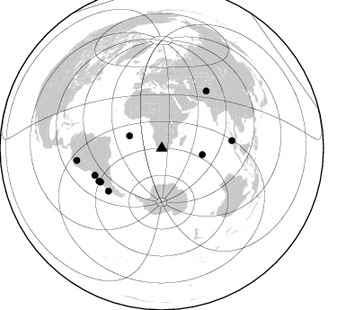
Nearby stations (2 deg radius)
| Station | Name | (Lat, Lon) | Start / End | Elevation |
| SA12 | XA.SA12 | (-29.85, 22.25) | 1997-05-06 / 1999-12-31 | 1125 m |
| Crust2 Type: | I7,late Proter., 1 km seds. |
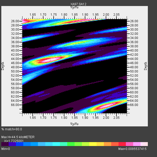
| Thickness Estimate: | 44 km |
| Thickness StdDev: | 15 km |
| Vp/Vs Estimate: | 1.73 |
| Vp/Vs StdDev: | 0.16 |
| Vs Estimate: | 3.816 km/s |
| Poisson's Ratio: | 0.25 |
| Peak Value: | 0.01 |
| Assumed Vp: | 6.612 km/s |
| Ps Weight: | 0.33333334 |
| PpPs Weight: | 0.33333334 |
| PsPs Weight: | 0.33333328 |
| Residual Complexity: | 0.826 |
| Nearby stations H: | +- |
| (2.0 deg) Vp/Vs: | +- |
4 with match > 90% ( 13.333333 %) and 10 with match > 80% ( 33.333332 %) out of 30.
Download stack as xyz text file.
Azimuth Distribution of Events:
Prior Results for this Station
| Study | Thickness | Vp/Vs | Vp | Vs | Poissons Ratio | Extra |
| EARS | 44 km | 1.73 | 6.612 km/s | 3.816 km/s | 0.25 | |
| Crust2.0 | 42 km | 1.78 | 6.612 km/s | 3.71 km/s | 0.27 | I7,late Proter., 1 km seds. |
| Global Maxima | 44 km | 1.73 | 6.612 km/s | 3.816 km/s | 0.25 | amp=0.0085537415 |
| Local Maxima 1 | 26 km | 1.60 | 6.612 km/s | 4.132 km/s | 0.18 | amp=0.008411916 |
| Local Maxima 2 | 66 km | 2.01 | 6.612 km/s | 3.294 km/s | 0.33 | amp=0.008156135 |
| Local Maxima 3 | 25 km | 1.91 | 6.612 km/s | 3.457 km/s | 0.31 | amp=0.0077701923 |
| Local Maxima 4 | 25 km | 1.60 | 6.612 km/s | 4.132 km/s | 0.18 | amp=0.006378384 |
| Predicted Arrivals for vertical incidence (zero ray parameter) | |
| Ps | 4.93 SECOND |
| PpPs | 18.39 SECOND |
| PsPs/PpSs | 23.32 SECOND |
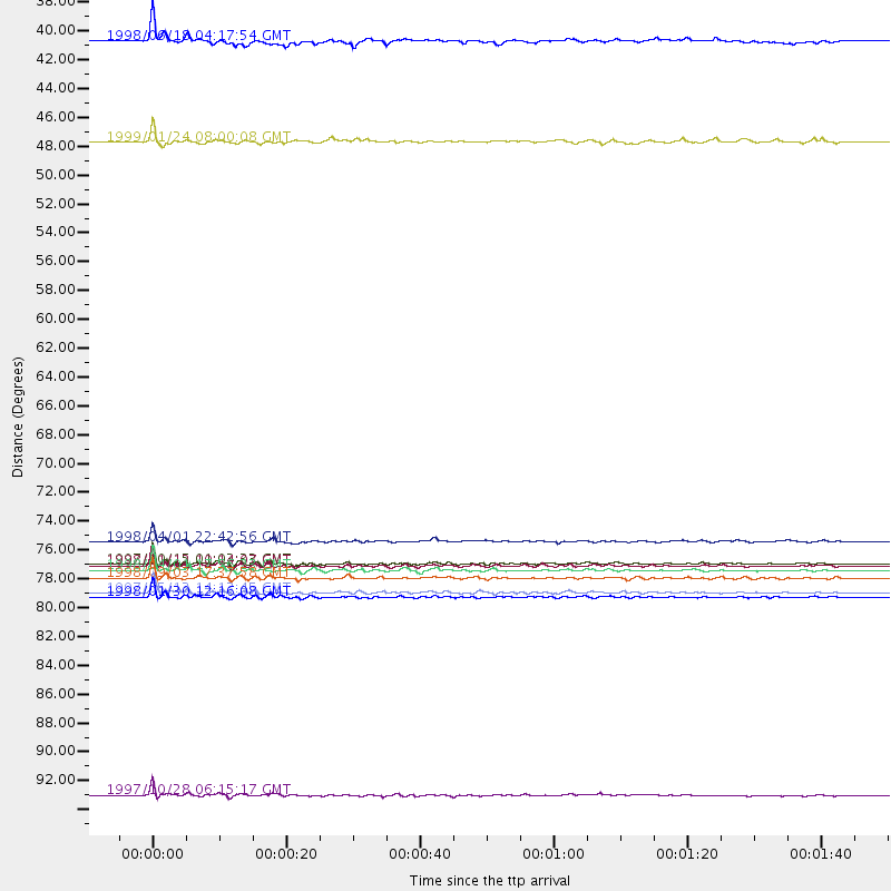
Events Processed for this Station
Download zip of receiver functions as SAC
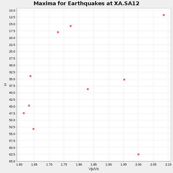
Plot maxima for each earthquake.
Events Used in the Stack
(10 events)| Radial Match | Distance | Baz | FERegion | Time | Lat/Lon | Depth | Magnitude |
| 97.34254 | 78.0 deg | 241.27 deg | Near Coast Of Central Chile | 1997/10/15 01:03:33 GMT | (-30.9, -71.2) | 58 km | 6.8 MB, 6.8 MS, 7.3 UNKNOWN, 7.1 MW |
| 96.20793 | 80.5 deg | 247.988 deg | Near Coast Of Northern Chile | 1998/01/30 12:16:08 GMT | (-23.9, -70.2) | 42 km | 6.3 MB, 6.5 MS, 7.0 UNKNOWN, 6.7 ME |
| 95.9559 | 79.1 deg | 242.401 deg | Near Coast Of Central Chile | 1998/09/03 17:37:58 GMT | (-29.5, -71.7) | 27 km | 6.2 MB, 6.6 MS, 6.5 UNKNOWN, 6.4 ME |
| 91.491585 | 76.3 deg | 231.344 deg | Off Coast Of Southern Chile | 1998/04/01 22:42:56 GMT | (-40.3, -74.9) | 9.0 km | 6.2 MB, 6.0 MS, 6.7 UNKNOWN, 6.6 ME |
| 88.70986 | 78.5 deg | 83.958 deg | Southern Sumatra, Indonesia | 1998/04/01 17:56:23 GMT | (-0.5, 99.3) | 56 km | 6.2 MB, 6.9 MS, 7.0 UNKNOWN, 6.6 ME |
| 87.98518 | 80.2 deg | 37.945 deg | Hindu Kush Region, Afghanistan | 1997/05/13 14:13:45 GMT | (36.4, 70.9) | 196 km | 6.1 MB, 6.5 UNKNOWN, 6.4 MW |
| 87.72814 | 78.1 deg | 241.146 deg | Near Coast Of Central Chile | 1998/01/12 10:14:07 GMT | (-31.0, -71.4) | 35 km | 5.8 MB, 6.2 MS, 6.6 UNKNOWN, 6.2 ME |
| 83.07912 | 45.8 deg | 99.072 deg | Mid-Indian Ridge | 1999/01/24 08:00:08 GMT | (-26.5, 74.5) | 10 km | 6.0 MB, 6.3 MS, 6.3 MW, 6.3 ME |
| 81.89836 | 95.6 deg | 261.773 deg | Northern Peru | 1997/10/28 06:15:17 GMT | (-4.4, -76.7) | 112 km | 6.6 MB, 6.3 MS, 7.2 UNKNOWN, 6.6 ME |
| 81.099304 | 38.2 deg | 290.724 deg | Ascension Island Region | 1998/06/18 04:17:54 GMT | (-11.6, -13.9) | 10 km | 6.1 MS, 5.4 MB, 6.2 UNKNOWN |
Losers
(20 events)| Radial Match | Distance | Baz | FERegion | Time | Lat/Lon | Depth | Magnitude | Reason |
| 95.93442 | 84.3 deg | 53.551 deg | Nepal | 1998/09/03 18:15:56 GMT | (27.9, 86.9) | 33 km | 5.6 MB | |
| 79.82072 | 81.6 deg | 157.669 deg | West Of Macquarie Island | 1998/06/29 23:37:16 GMT | (-60.4, 153.1) | 10 km | 5.8 MS, 5.0 MB, 6.3 UNKNOWN, 6.0 MW | |
| 78.72073 | 45.5 deg | 213.749 deg | South Sandwich Islands Region | 1997/10/05 18:04:30 GMT | (-59.7, -29.2) | 274 km | 6.0 MB, 6.3 UNKNOWN, 6.3 MW | |
| 78.39078 | 78.9 deg | 241.79 deg | Near Coast Of Central Chile | 1997/07/06 09:54:00 GMT | (-30.1, -71.9) | 19 km | 5.8 MB, 6.5 MS, 6.8 UNKNOWN, 6.4 ME | |
| 76.200836 | 77.4 deg | 239.995 deg | Near Coast Of Central Chile | 1998/07/29 07:14:24 GMT | (-32.3, -71.3) | 51 km | 6.3 MB, 6.5 UNKNOWN, 6.5 ME | |
| 72.30324 | 76.5 deg | 53.252 deg | Southern India | 1997/05/21 22:51:28 GMT | (23.1, 80.0) | 36 km | 6.0 MB, 5.6 MS, 5.8 UNKNOWN, 5.6 ME | |
| 71.06425 | 78.4 deg | 293.255 deg | Northern Mid-Atlantic Ridge | 1998/10/01 03:41:13 GMT | (13.7, -45.6) | 10 km | 5.4 MB, 5.5 MS, 6.1 UNKNOWN, 5.9 MW | |
| 69.77026 | 74.6 deg | 234.664 deg | S. Chile-Argentina Border Region | 1998/12/14 16:25:24 GMT | (-38.2, -71.0) | 138 km | 6.0 UNKNOWN, 4.8 MS, 5.4 MB | |
| 67.13824 | 80.3 deg | 37.985 deg | Afghanistan-Tajikistan Bord Reg. | 1998/02/20 12:18:06 GMT | (36.5, 71.1) | 236 km | 5.8 MB, 5.7 MS, 6.4 UNKNOWN, 6.3 MW | |
| 64.911964 | 84.2 deg | 257.59 deg | Peru-Bolivia Border Region | 1997/11/28 22:53:41 GMT | (-13.7, -68.8) | 586 km | 6.4 MB, 6.6 UNKNOWN, 6.6 MW | |
| 64.13941 | 86.0 deg | 39.386 deg | Southern Xinjiang, China | 1998/08/27 09:03:36 GMT | (39.7, 77.3) | 33 km | 5.6 MB, 6.4 MS, 6.3 UNKNOWN, 6.3 MW | |
| 64.11095 | 78.3 deg | 74.518 deg | Nicobar Islands, India Region | 1998/08/10 09:52:14 GMT | (7.3, 94.3) | 33 km | 5.9 MB, 5.8 MS, 6.0 UNKNOWN | |
| 57.27632 | 79.1 deg | 242.565 deg | Near Coast Of Central Chile | 1997/07/19 12:22:57 GMT | (-29.3, -71.7) | 26 km | 5.8 MB, 5.5 MS, 5.9 UNKNOWN, 5.8 MW | |
| 55.651478 | 77.4 deg | 77.881 deg | Northern Sumatra, Indonesia | 1999/02/04 19:28:00 GMT | (4.0, 95.3) | 56 km | 5.8 MB, 5.4 MS, 5.9 MW, 5.9 MW | |
| 55.19833 | 85.9 deg | 94.205 deg | Java Sea | 1997/07/11 09:55:12 GMT | (-5.7, 110.8) | 574 km | 5.6 MB | |
| 53.73022 | 32.7 deg | 249.934 deg | Southern Mid-Atlantic Ridge | 1998/01/03 06:10:08 GMT | (-35.5, -16.2) | 10 km | 5.9 MS, 5.4 MB, 6.3 UNKNOWN, 6.1 MW | |
| 53.547695 | 96.5 deg | 93.466 deg | Minahassa Peninsula, Sulawesi | 1998/05/21 05:34:25 GMT | (0.2, 119.6) | 33 km | 6.2 MB, 6.3 MS, 6.6 UNKNOWN, 6.6 MW | |
| 50.85379 | 43.6 deg | 78.216 deg | Mid-Indian Ridge | 1997/09/25 14:20:48 GMT | (-13.8, 66.2) | 10 km | 5.3 MB, 5.7 MS, 6.0 UNKNOWN, 6.0 MW | |
| 49.761036 | 77.7 deg | 250.526 deg | Jujuy Province, Argentina | 1997/07/20 10:14:22 GMT | (-23.0, -66.3) | 256 km | 5.7 MB, 6.1 UNKNOWN, 5.7 ME | |
| 46.579113 | 45.7 deg | 77.435 deg | Mid-Indian Ridge | 1998/04/09 23:26:52 GMT | (-12.2, 67.8) | 10 km | 5.5 MB, 5.4 MS, 5.9 UNKNOWN, 5.9 MW |
