
Station XA SA14 - XA.SA14
Network: XA97 - Anatomy of an Archean Craton, South Africa
Nearby stations (2 deg radius)
| Station | Name | (Lat, Lon) | Start / End | Elevation |
| SA14 | XA.SA14 | (-29.87, 24.02) | 1998-04-27 / 1999-12-31 | 1200 m |
| Crust2 Type: | G1,Archean, no seds. |
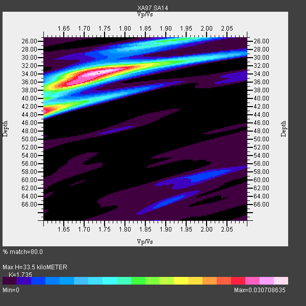
| Thickness Estimate: | 34 km |
| Thickness StdDev: | 4.3 km |
| Vp/Vs Estimate: | 1.74 |
| Vp/Vs StdDev: | 0.06 |
| Vs Estimate: | 3.723 km/s |
| Poisson's Ratio: | 0.25 |
| Peak Value: | 0.03 |
| Assumed Vp: | 6.459 km/s |
| Ps Weight: | 0.33333334 |
| PpPs Weight: | 0.33333334 |
| PsPs Weight: | 0.33333328 |
| Residual Complexity: | 0.591 |
| Nearby stations H: | +- |
| (2.0 deg) Vp/Vs: | +- |
2 with match > 90% ( 15.384615 %) and 6 with match > 80% ( 46.153847 %) out of 13.
Download stack as xyz text file.
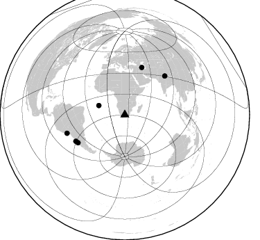
Azimuth Distribution of Events:
Prior Results for this Station
| Study | Thickness | Vp/Vs | Vp | Vs | Poissons Ratio | Extra |
| EARS | 34 km | 1.74 | 6.459 km/s | 3.723 km/s | 0.25 | |
| Crust2.0 | 37 km | 1.76 | 6.459 km/s | 3.665 km/s | 0.26 | G1,Archean, no seds. |
| Global Maxima | 34 km | 1.74 | 6.459 km/s | 3.723 km/s | 0.25 | amp=0.030708635 |
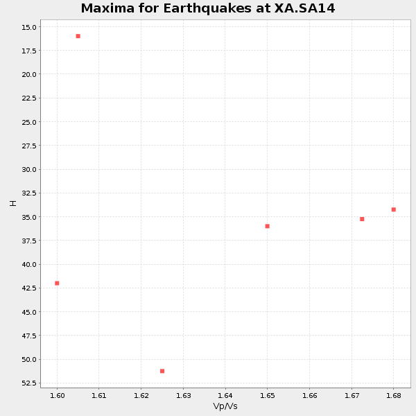
| Local Maxima 1 | 43 km | 1.60 | 6.459 km/s | 4.037 km/s | 0.18 | amp=0.026714716 |
| Local Maxima 2 | 36 km | 1.67 | 6.459 km/s | 3.868 km/s | 0.22 | amp=0.019864103 |
| Local Maxima 3 | 26 km | 1.90 | 6.459 km/s | 3.391 km/s | 0.31 | amp=0.013770954 |
| Local Maxima 4 | 42 km | 1.60 | 6.459 km/s | 4.037 km/s | 0.18 | amp=0.009630484 |
| Predicted Arrivals for vertical incidence (zero ray parameter) | |
| Ps | 3.81 SECOND |
| PpPs | 14.18 SECOND |
| PsPs/PpSs | 18.00 SECOND |
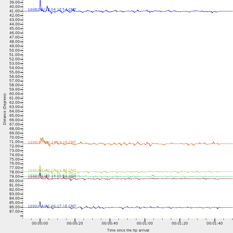
Events Processed for this Station
Download zip of receiver functions as SAC
Plot maxima for each earthquake.
Events Used in the Stack
(6 events)| Radial Match | Distance | Baz | FERegion | Time | Lat/Lon | Depth | Magnitude |
| 93.91348 | 79.9 deg | 46.171 deg | Western Xizang-India Border Reg. | 1999/03/28 19:05:11 GMT | (30.5, 79.4) | 15 km | 6.4 MB, 6.6 MS, 6.6 MW, 6.5 ME |
| 93.735115 | 80.4 deg | 241.658 deg | Near Coast Of Central Chile | 1998/09/03 17:37:58 GMT | (-29.5, -71.7) | 27 km | 6.2 MB, 6.6 MS, 6.5 UNKNOWN, 6.4 ME |
| 88.776794 | 72.0 deg | 19.937 deg | Armenia-Azerbaijan-Iran Bord Reg | 1998/07/09 14:19:18 GMT | (38.7, 48.5) | 26 km | 5.9 MB, 6.0 UNKNOWN, 5.7 ME |
| 85.27402 | 39.6 deg | 289.219 deg | Ascension Island Region | 1998/06/18 04:17:54 GMT | (-11.6, -13.9) | 10 km | 6.1 MS, 5.4 MB, 6.2 UNKNOWN |
| 84.292076 | 78.7 deg | 239.286 deg | Near Coast Of Central Chile | 1998/07/29 07:14:24 GMT | (-32.3, -71.3) | 51 km | 6.3 MB, 6.5 UNKNOWN, 6.5 ME |
| 80.53704 | 87.5 deg | 252.358 deg | Near Coast Of Peru | 1999/04/03 06:17:18 GMT | (-16.7, -72.7) | 87 km | 6.1 MB, 6.2 MS, 6.8 MW, 6.8 MW |
Losers
(7 events)| Radial Match | Distance | Baz | FERegion | Time | Lat/Lon | Depth | Magnitude | Reason |
| 79.59868 | 35.1 deg | 246.651 deg | Southern Mid-Atlantic Ridge | 1998/06/24 10:44:30 GMT | (-37.3, -17.4) | 10 km | 5.7 MB, 5.8 MS, 6.0 UNKNOWN, 5.9 MW | |
| 79.1258 | 44.2 deg | 219.158 deg | South Sandwich Islands Region | 1998/08/29 08:30:21 GMT | (-55.7, -27.0) | 33 km | 5.6 MB, 5.6 MS, 6.0 UNKNOWN, 5.9 MW | |
| 76.151085 | 75.8 deg | 234.028 deg | S. Chile-Argentina Border Region | 1998/12/14 16:25:24 GMT | (-38.2, -71.0) | 138 km | 6.0 UNKNOWN, 4.8 MS, 5.4 MB | |
| 68.55107 | 64.9 deg | 79.677 deg | South Indian Ocean | 1999/03/29 06:17:58 GMT | (-4.0, 87.3) | 10 km | 5.5 MS, 5.4 MB, 5.8 MW, 5.8 MW | |
| 59.688267 | 75.9 deg | 76.92 deg | Northern Sumatra, Indonesia | 1999/02/04 19:28:00 GMT | (4.0, 95.3) | 56 km | 5.8 MB, 5.4 MS, 5.9 MW, 5.9 MW | |
| 57.98898 | 86.7 deg | 253.43 deg | Southern Peru | 1998/10/08 04:51:42 GMT | (-16.1, -71.4) | 136 km | 6.1 MB, 6.4 UNKNOWN, 6.2 MW | |
| 57.98555 | 94.9 deg | 92.568 deg | Minahassa Peninsula, Sulawesi | 1999/02/23 07:27:56 GMT | (0.2, 119.5) | 33 km | 5.6 MB, 5.8 MS |
