
Station XA SA155 - XA.SA155
Network: XA97 - Anatomy of an Archean Craton, South Africa
Nearby stations (2 deg radius)
| Station | Name | (Lat, Lon) | Start / End | Elevation |
| SA155 | XA.SA155 | (-22.88, 28.34) | 1998-05-30 / 1999-12-31 | 900 m |
| Crust2 Type: | G1,Archean, no seds. |
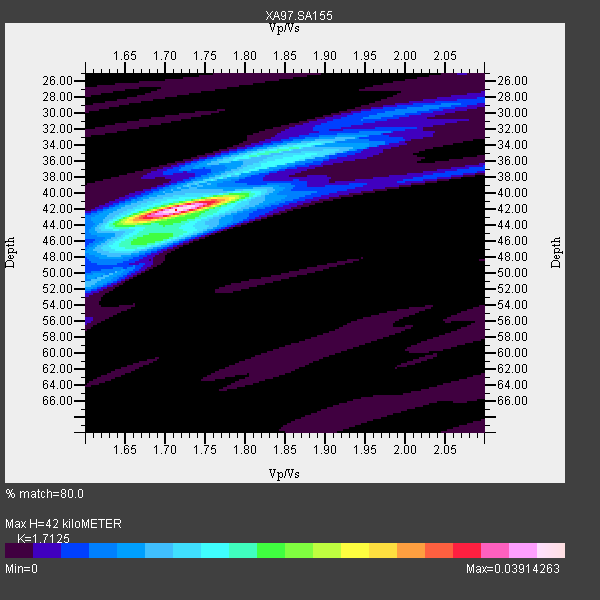
| Thickness Estimate: | 42 km |
| Thickness StdDev: | 2.3 km |
| Vp/Vs Estimate: | 1.71 |
| Vp/Vs StdDev: | 0.05 |
| Vs Estimate: | 3.772 km/s |
| Poisson's Ratio: | 0.24 |
| Peak Value: | 0.04 |
| Assumed Vp: | 6.459 km/s |
| Ps Weight: | 0.33333334 |
| PpPs Weight: | 0.33333334 |
| PsPs Weight: | 0.33333328 |
| Residual Complexity: | 0.424 |
| Nearby stations H: | +- |
| (2.0 deg) Vp/Vs: | +- |
2 with match > 90% ( 11.111111 %) and 5 with match > 80% ( 27.777779 %) out of 18.
Download stack as xyz text file.
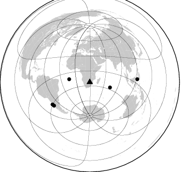
Azimuth Distribution of Events:
Prior Results for this Station
| Study | Thickness | Vp/Vs | Vp | Vs | Poissons Ratio | Extra |
| EARS | 42 km | 1.71 | 6.459 km/s | 3.772 km/s | 0.24 | |
| Crust2.0 | 37 km | 1.76 | 6.459 km/s | 3.665 km/s | 0.26 | G1,Archean, no seds. |
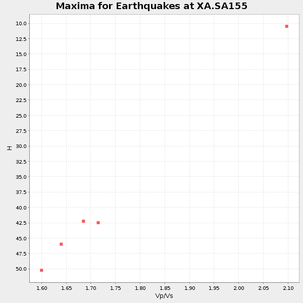
| Global Maxima | 42 km | 1.71 | 6.459 km/s | 3.772 km/s | 0.24 | amp=0.03914263 |
| Local Maxima 1 | 34 km | 1.87 | 6.459 km/s | 3.454 km/s | 0.30 | amp=0.013951135 |
| Local Maxima 2 | 45 km | 1.71 | 6.459 km/s | 3.783 km/s | 0.24 | amp=0.012699523 |
| Local Maxima 3 | 36 km | 1.88 | 6.459 km/s | 3.44 km/s | 0.30 | amp=0.007823689 |
| Local Maxima 4 | 52 km | 1.60 | 6.459 km/s | 4.031 km/s | 0.18 | amp=0.006933205 |
| Predicted Arrivals for vertical incidence (zero ray parameter) | |
| Ps | 4.63 SECOND |
| PpPs | 17.64 SECOND |
| PsPs/PpSs | 22.27 SECOND |
Events Processed for this Station
Download zip of receiver functions as SAC
Plot maxima for each earthquake.
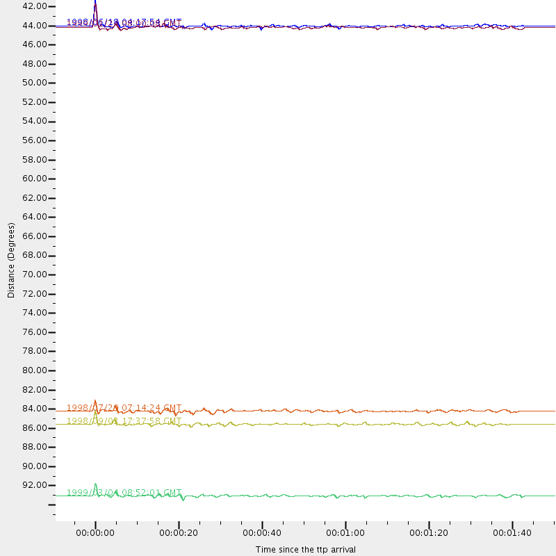
Events Used in the Stack
(5 events)| Radial Match | Distance | Baz | FERegion | Time | Lat/Lon | Depth | Magnitude |
| 92.99701 | 87.2 deg | 239.296 deg | Near Coast Of Central Chile | 1998/09/03 17:37:58 GMT | (-29.5, -71.7) | 27 km | 6.2 MB, 6.6 MS, 6.5 UNKNOWN, 6.4 ME |
| 90.8913 | 41.9 deg | 104.625 deg | Mid-Indian Ridge | 1999/01/24 08:00:08 GMT | (-26.5, 74.5) | 10 km | 6.0 MB, 6.3 MS, 6.3 MW, 6.3 ME |
| 89.50783 | 41.7 deg | 278.348 deg | Ascension Island Region | 1998/06/18 04:17:54 GMT | (-11.6, -13.9) | 10 km | 6.1 MS, 5.4 MB, 6.2 UNKNOWN |
| 88.440445 | 95.4 deg | 86.428 deg | Celebes Sea | 1999/03/04 08:52:01 GMT | (5.4, 121.9) | 33 km | 6.4 MB, 6.5 MS, 7.1 MW, 7.1 MW |
| 81.71435 | 85.7 deg | 236.846 deg | Near Coast Of Central Chile | 1998/07/29 07:14:24 GMT | (-32.3, -71.3) | 51 km | 6.3 MB, 6.5 UNKNOWN, 6.5 ME |
Losers
(13 events)| Radial Match | Distance | Baz | FERegion | Time | Lat/Lon | Depth | Magnitude | Reason |
| 95.13198 | 83.1 deg | 231.522 deg | S. Chile-Argentina Border Region | 1998/12/14 16:25:24 GMT | (-38.2, -71.0) | 138 km | 6.0 UNKNOWN, 4.8 MS, 5.4 MB | |
| 78.97201 | 58.0 deg | 30.092 deg | Southern Iran | 1999/03/04 05:38:26 GMT | (28.3, 57.2) | 33 km | 6.2 MB, 6.5 MS, 6.6 MW, 6.4 MW | |
| 77.667274 | 83.3 deg | 238.748 deg | San Juan Province, Argentina | 1998/06/07 16:10:46 GMT | (-31.5, -67.8) | 113 km | 5.6 MB, 5.9 UNKNOWN, 5.9 MW | |
| 76.46222 | 97.1 deg | 100.571 deg | Banda Sea | 1998/11/09 05:30:14 GMT | (-7.0, 129.0) | 33 km | 6.1 MB, 6.7 UNKNOWN, 6.6 ME | |
| 74.04034 | 97.0 deg | 100.509 deg | Banda Sea | 1998/11/09 05:38:44 GMT | (-6.9, 128.9) | 33 km | 6.4 MB, 7.0 MS, 7.3 UNKNOWN, 7.0 MW | |
| 73.73831 | 52.0 deg | 216.182 deg | South Sandwich Islands Region | 1998/08/29 08:30:21 GMT | (-55.7, -27.0) | 33 km | 5.6 MB, 5.6 MS, 6.0 UNKNOWN, 5.9 MW | |
| 72.97321 | 81.4 deg | 95.284 deg | Java, Indonesia | 1998/09/28 13:34:30 GMT | (-8.2, 112.4) | 152 km | 6.4 MB, 6.5 UNKNOWN, 6.5 MW | |
| 69.70644 | 85.7 deg | 151.075 deg | West Of Macquarie Island | 1998/08/04 15:51:01 GMT | (-56.7, 147.4) | 10 km | 5.5 MS, 5.3 MB | |
| 68.74776 | 71.5 deg | 35.161 deg | Afghanistan-Tajikistan Bord Reg. | 1998/12/11 20:16:24 GMT | (36.5, 71.0) | 223 km | 5.7 UNKNOWN, 5.0 MB, 5.6 MW | |
| 60.245216 | 77.2 deg | 36.686 deg | Southern Xinjiang, China | 1998/08/27 09:03:36 GMT | (39.7, 77.3) | 33 km | 5.6 MB, 6.4 MS, 6.3 UNKNOWN, 6.3 MW | |
| 59.54445 | 91.2 deg | 90.281 deg | Minahassa Peninsula, Sulawesi | 1999/02/23 07:27:56 GMT | (0.2, 119.5) | 33 km | 5.6 MB, 5.8 MS | |
| 58.78857 | 70.5 deg | 76.79 deg | Northern Sumatra, Indonesia | 1999/02/04 19:28:00 GMT | (4.0, 95.3) | 56 km | 5.8 MB, 5.4 MS, 5.9 MW, 5.9 MW | |
| 37.345543 | 96.1 deg | 92.733 deg | Southern Molucca Sea | 1998/08/28 12:40:58 GMT | (-0.2, 125.0) | 66 km | 6.2 MB, 6.1 UNKNOWN, 6.1 MW |
