
Station XA SA169 - XA.SA169
Network: XA97 - Anatomy of an Archean Craton, South Africa
Nearby stations (2 deg radius)
| Station | Name | (Lat, Lon) | Start / End | Elevation |
| SA169 | XA.SA169 | (-22.26, 29.21) | 1997-11-14 / 1999-12-31 | 618 m |
| Crust2 Type: | G1,Archean, no seds. |
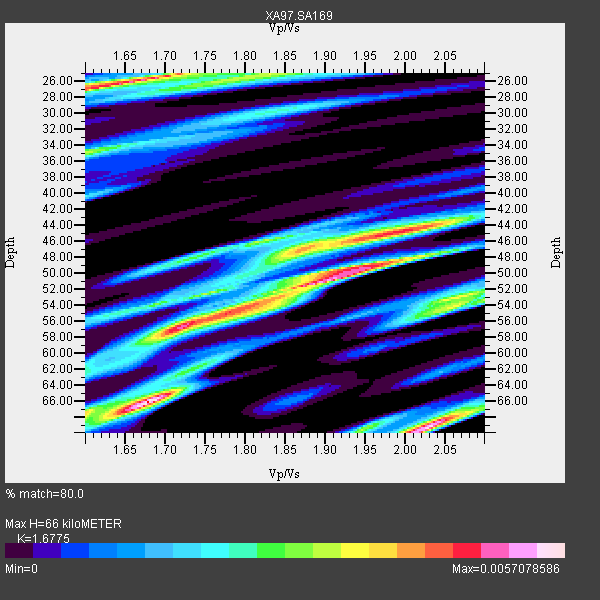
| Thickness Estimate: | 66 km |
| Thickness StdDev: | 6.9 km |
| Vp/Vs Estimate: | 1.68 |
| Vp/Vs StdDev: | 0.12 |
| Vs Estimate: | 3.851 km/s |
| Poisson's Ratio: | 0.22 |
| Peak Value: | 0.01 |
| Assumed Vp: | 6.459 km/s |
| Ps Weight: | 0.33333334 |
| PpPs Weight: | 0.33333334 |
| PsPs Weight: | 0.33333328 |
| Residual Complexity: | 0.922 |
| Nearby stations H: | +- |
| (2.0 deg) Vp/Vs: | +- |
5 with match > 90% ( 27.777779 %) and 5 with match > 80% ( 27.777779 %) out of 18.
Download stack as xyz text file.
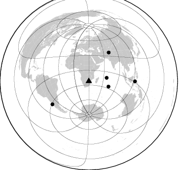
Azimuth Distribution of Events:
Prior Results for this Station
| Study | Thickness | Vp/Vs | Vp | Vs | Poissons Ratio | Extra |
| EARS | 66 km | 1.68 | 6.459 km/s | 3.851 km/s | 0.22 | |
| Crust2.0 | 37 km | 1.76 | 6.459 km/s | 3.665 km/s | 0.26 | G1,Archean, no seds. |
| Global Maxima | 66 km | 1.68 | 6.459 km/s | 3.851 km/s | 0.22 | amp=0.0057078586 |
| Local Maxima 1 | 69 km | 2.03 | 6.459 km/s | 3.19 km/s | 0.34 | amp=0.005513229 |
| Local Maxima 2 | 51 km | 1.89 | 6.459 km/s | 3.409 km/s | 0.31 | amp=0.0050845062 |
| Local Maxima 3 | 26 km | 1.67 | 6.459 km/s | 3.868 km/s | 0.22 | amp=0.0049135145 |
| Local Maxima 4 | 57 km | 1.72 | 6.459 km/s | 3.761 km/s | 0.24 | amp=0.004686739 |
| Predicted Arrivals for vertical incidence (zero ray parameter) | |
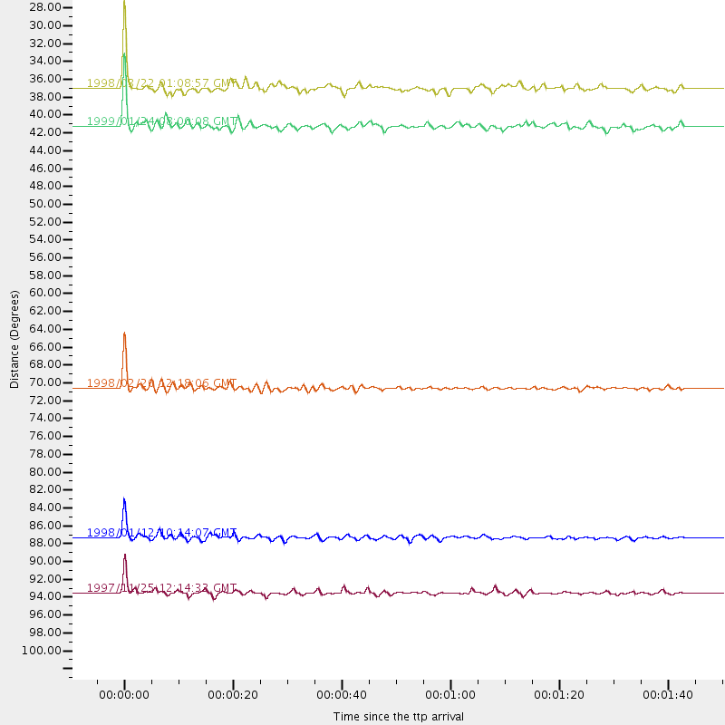
| Ps | 6.92 SECOND |
| PpPs | 27.36 SECOND |
| PsPs/PpSs | 34.28 SECOND |
Events Processed for this Station
Download zip of receiver functions as SAC
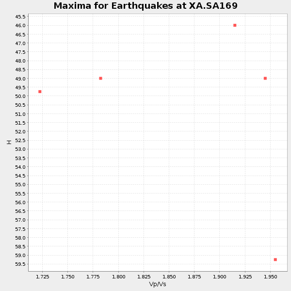
Plot maxima for each earthquake.
Events Used in the Stack
(5 events)| Radial Match | Distance | Baz | FERegion | Time | Lat/Lon | Depth | Magnitude |
| 94.63991 | 87.3 deg | 237.673 deg | Near Coast Of Central Chile | 1998/01/12 10:14:07 GMT | (-31.0, -71.4) | 35 km | 5.8 MB, 6.2 MS, 6.6 UNKNOWN, 6.2 ME |
| 93.35045 | 41.3 deg | 105.193 deg | Mid-Indian Ridge | 1999/01/24 08:00:08 GMT | (-26.5, 74.5) | 10 km | 6.0 MB, 6.3 MS, 6.3 MW, 6.3 ME |
| 93.0601 | 93.5 deg | 90.109 deg | Minahassa Peninsula, Sulawesi | 1997/11/25 12:14:33 GMT | (1.2, 122.5) | 24 km | 6.1 MB, 6.8 MS, 7.1 UNKNOWN, 6.7 ME |
| 91.77119 | 70.6 deg | 34.787 deg | Afghanistan-Tajikistan Bord Reg. | 1998/02/20 12:18:06 GMT | (36.5, 71.1) | 236 km | 5.8 MB, 5.7 MS, 6.4 UNKNOWN, 6.3 MW |
| 90.92668 | 36.9 deg | 79.22 deg | Mid-Indian Ridge | 1998/03/22 01:08:57 GMT | (-11.4, 66.2) | 10 km | 5.4 MB, 6.1 MS, 6.1 UNKNOWN, 6.1 MW |
Losers
(13 events)| Radial Match | Distance | Baz | FERegion | Time | Lat/Lon | Depth | Magnitude | Reason |
| 83.66832 | 77.1 deg | 91.027 deg | Java, Indonesia | 1999/03/07 01:32:27 GMT | (-5.8, 107.6) | 325 km | 5.6 MW, 5.0 MB | |
| 78.115395 | 60.1 deg | 352.158 deg | Ionian Sea | 1997/11/18 13:07:41 GMT | (37.6, 20.7) | 33 km | 5.9 MB, 6.4 MS, 6.7 UNKNOWN, 6.1 ML | |
| 77.86242 | 68.0 deg | 35.183 deg | Southeastern Afghanistan | 1999/02/11 14:08:51 GMT | (34.3, 69.4) | 33 km | 5.8 MS, 5.4 MB, 6.0 MW, 6.0 MW | |
| 72.62966 | 82.1 deg | 156.694 deg | South Of Australia | 1998/03/25 12:17:22 GMT | (-63.6, 147.9) | 10 km | 5.8 MB, 6.1 MS, 6.5 UNKNOWN | |
| 71.67898 | 57.1 deg | 29.507 deg | Southern Iran | 1999/03/04 05:38:26 GMT | (28.3, 57.2) | 33 km | 6.2 MB, 6.5 MS, 6.6 MW, 6.4 MW | |
| 68.03399 | 69.6 deg | 76.605 deg | Northern Sumatra, Indonesia | 1999/02/04 19:28:00 GMT | (4.0, 95.3) | 56 km | 5.8 MB, 5.4 MS, 5.9 MW, 5.9 MW | |
| 65.647995 | 88.3 deg | 246.261 deg | Northern Chile | 1999/03/02 17:45:55 GMT | (-22.7, -68.5) | 111 km | 5.8 MB, 6.1 MW, 5.9 MW | |
| 63.853237 | 53.0 deg | 216.071 deg | South Sandwich Islands Region | 1998/08/29 08:30:21 GMT | (-55.7, -27.0) | 33 km | 5.6 MB, 5.6 MS, 6.0 UNKNOWN, 5.9 MW | |
| 61.454063 | 70.5 deg | 34.721 deg | Afghanistan-Tajikistan Bord Reg. | 1998/12/11 20:16:24 GMT | (36.5, 71.0) | 223 km | 5.7 UNKNOWN, 5.0 MB, 5.6 MW | |
| 55.736214 | 96.6 deg | 91.777 deg | Northern Molucca Sea | 1998/10/28 16:25:03 GMT | (0.8, 126.0) | 33 km | 6.2 MB, 6.2 MS, 6.6 UNKNOWN, 6.6 MW | |
| 54.746384 | 84.1 deg | 231.191 deg | S. Chile-Argentina Border Region | 1998/12/14 16:25:24 GMT | (-38.2, -71.0) | 138 km | 6.0 UNKNOWN, 4.8 MS, 5.4 MB | |
| 52.600468 | 95.3 deg | 92.335 deg | Southern Molucca Sea | 1998/08/28 12:40:58 GMT | (-0.2, 125.0) | 66 km | 6.2 MB, 6.1 UNKNOWN, 6.1 MW | |
| 51.267857 | 92.1 deg | 254.35 deg | Peru-Bolivia Border Region | 1997/11/28 22:53:41 GMT | (-13.7, -68.8) | 586 km | 6.4 MB, 6.6 UNKNOWN, 6.6 MW |
