
Station XA SA19 - XA.SA19
Network: XA97 - Anatomy of an Archean Craton, South Africa
Nearby stations (2 deg radius)
| Station | Name | (Lat, Lon) | Start / End | Elevation |
| SA19 | XA.SA19 | (-28.91, 24.83) | 1998-04-20 / 1999-12-31 | 1200 m |
| Crust2 Type: | G1,Archean, no seds. |
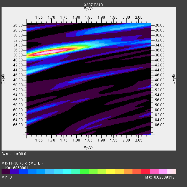
| Thickness Estimate: | 37 km |
| Thickness StdDev: | 0.8 km |
| Vp/Vs Estimate: | 1.69 |
| Vp/Vs StdDev: | 0.04 |
| Vs Estimate: | 3.834 km/s |
| Poisson's Ratio: | 0.23 |
| Peak Value: | 0.03 |
| Assumed Vp: | 6.459 km/s |
| Ps Weight: | 0.33333334 |
| PpPs Weight: | 0.33333334 |
| PsPs Weight: | 0.33333328 |
| Residual Complexity: | 0.443 |
| Nearby stations H: | +- |
| (2.0 deg) Vp/Vs: | +- |
3 with match > 90% ( 17.647058 %) and 3 with match > 80% ( 17.647058 %) out of 17.
Download stack as xyz text file.
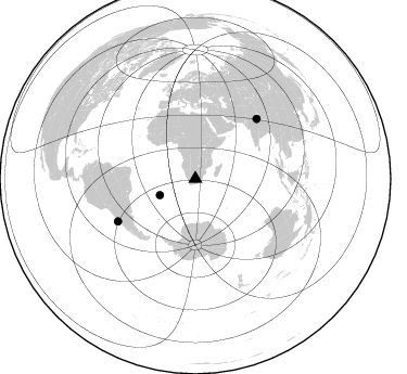
Azimuth Distribution of Events:
Prior Results for this Station
| Study | Thickness | Vp/Vs | Vp | Vs | Poissons Ratio | Extra |
| EARS | 37 km | 1.69 | 6.459 km/s | 3.834 km/s | 0.23 | |
| Crust2.0 | 37 km | 1.76 | 6.459 km/s | 3.665 km/s | 0.26 | G1,Archean, no seds. |
| Global Maxima | 37 km | 1.69 | 6.459 km/s | 3.834 km/s | 0.23 | amp=0.02839312 |
| Local Maxima 1 | 45 km | 1.61 | 6.459 km/s | 4.025 km/s | 0.18 | amp=0.010434826 |
| Local Maxima 2 | 34 km | 1.77 | 6.459 km/s | 3.655 km/s | 0.26 | amp=0.008816835 |
| Local Maxima 3 | 36 km | 1.78 | 6.459 km/s | 3.624 km/s | 0.27 | amp=0.0062801167 |
| Local Maxima 4 | 27 km | 1.97 | 6.459 km/s | 3.275 km/s | 0.33 | amp=0.005247199 |
| Predicted Arrivals for vertical incidence (zero ray parameter) | |
| Ps | 3.90 SECOND |
| PpPs | 15.28 SECOND |
| PsPs/PpSs | 19.17 SECOND |
Events Processed for this Station
Download zip of receiver functions as SAC
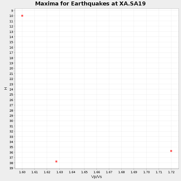
Plot maxima for each earthquake.
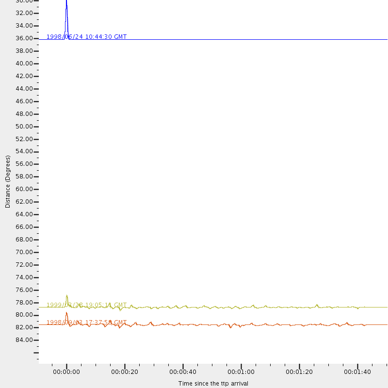
Events Used in the Stack
(3 events)| Radial Match | Distance | Baz | FERegion | Time | Lat/Lon | Depth | Magnitude |
| 99.902214 | 36.1 deg | 245.431 deg | Southern Mid-Atlantic Ridge | 1998/06/24 10:44:30 GMT | (-37.3, -17.4) | 10 km | 5.7 MB, 5.8 MS, 6.0 UNKNOWN, 5.9 MW |
| 94.0493 | 81.5 deg | 241.182 deg | Near Coast Of Central Chile | 1998/09/03 17:37:58 GMT | (-29.5, -71.7) | 27 km | 6.2 MB, 6.6 MS, 6.5 UNKNOWN, 6.4 ME |
| 93.75595 | 78.7 deg | 45.813 deg | Western Xizang-India Border Reg. | 1999/03/28 19:05:11 GMT | (30.5, 79.4) | 15 km | 6.4 MB, 6.6 MS, 6.6 MW, 6.5 ME |
Losers
(14 events)| Radial Match | Distance | Baz | FERegion | Time | Lat/Lon | Depth | Magnitude | Reason |
| 81.732124 | 95.6 deg | 223.221 deg | West Chile Rise | 1998/09/07 00:39:30 GMT | (-36.2, -97.7) | 10 km | 5.2 MB, 5.7 MS, 6.2 UNKNOWN, 6.1 MW | |
| 78.16584 | 43.8 deg | 99.105 deg | Mid-Indian Ridge | 1999/01/24 08:00:08 GMT | (-26.5, 74.5) | 10 km | 6.0 MB, 6.3 MS, 6.3 MW, 6.3 ME | |
| 74.29663 | 79.8 deg | 238.804 deg | Near Coast Of Central Chile | 1998/07/29 07:14:24 GMT | (-32.3, -71.3) | 51 km | 6.3 MB, 6.5 UNKNOWN, 6.5 ME | |
| 68.26172 | 87.6 deg | 252.999 deg | Southern Peru | 1998/10/08 04:51:42 GMT | (-16.1, -71.4) | 136 km | 6.1 MB, 6.4 UNKNOWN, 6.2 MW | |
| 64.03535 | 88.4 deg | 251.937 deg | Near Coast Of Peru | 1999/04/03 06:17:18 GMT | (-16.7, -72.7) | 87 km | 6.1 MB, 6.2 MS, 6.8 MW, 6.8 MW | |
| 58.157364 | 77.0 deg | 233.547 deg | S. Chile-Argentina Border Region | 1998/12/14 16:25:24 GMT | (-38.2, -71.0) | 138 km | 6.0 UNKNOWN, 4.8 MS, 5.4 MB | |
| 55.75955 | 77.8 deg | 90.344 deg | Sunda Strait, Indonesia | 1999/02/03 06:35:56 GMT | (-6.2, 104.2) | 33 km | 5.6 MB, 5.6 MS, 5.8 MW, 5.7 MW | |
| 54.356377 | 84.1 deg | 51.101 deg | Xizang | 1998/08/25 07:41:40 GMT | (30.1, 88.1) | 33 km | 5.5 MS, 5.3 MB, 5.7 UNKNOWN | |
| 53.973118 | 75.0 deg | 76.725 deg | Northern Sumatra, Indonesia | 1999/02/04 19:28:00 GMT | (4.0, 95.3) | 56 km | 5.8 MB, 5.4 MS, 5.9 MW, 5.9 MW | |
| 51.69619 | 84.2 deg | 51.092 deg | Xizang | 1998/07/20 01:05:58 GMT | (30.1, 88.2) | 33 km | 5.7 UNKNOWN, 5.4 MS, 5.4 MB | |
| 50.98795 | 80.9 deg | 91.603 deg | Java, Indonesia | 1999/03/07 01:32:27 GMT | (-5.8, 107.6) | 325 km | 5.6 MW, 5.0 MB | |
| 48.25448 | 86.6 deg | 300.197 deg | Northern Mid-Atlantic Ridge | 1999/04/06 04:51:05 GMT | (24.5, -46.4) | 10 km | 5.6 MS, 5.3 MB, 5.9 MW, 5.8 MW | |
| 46.868366 | 97.6 deg | 94.138 deg | Minahassa Peninsula, Sulawesi | 1999/06/02 00:23:19 GMT | (0.1, 123.5) | 161 km | 5.8 MB, 5.6 MW | |
| 38.775436 | 91.8 deg | 100.447 deg | Flores Region, Indonesia | 1998/12/07 23:37:06 GMT | (-8.3, 121.4) | 33 km | 5.5 MB, 5.4 MS, 5.9 UNKNOWN, 5.8 MW |
