
Station XA SA23 - XA.SA23
Network: XA97 - Anatomy of an Archean Craton, South Africa
Nearby stations (2 deg radius)
| Station | Name | (Lat, Lon) | Start / End | Elevation |
| SA23 | XA.SA23 | (-27.93, 23.40) | 1997-04-15 / 1999-12-31 | 1612 m |
| Crust2 Type: | I7,late Proter., 1 km seds. |
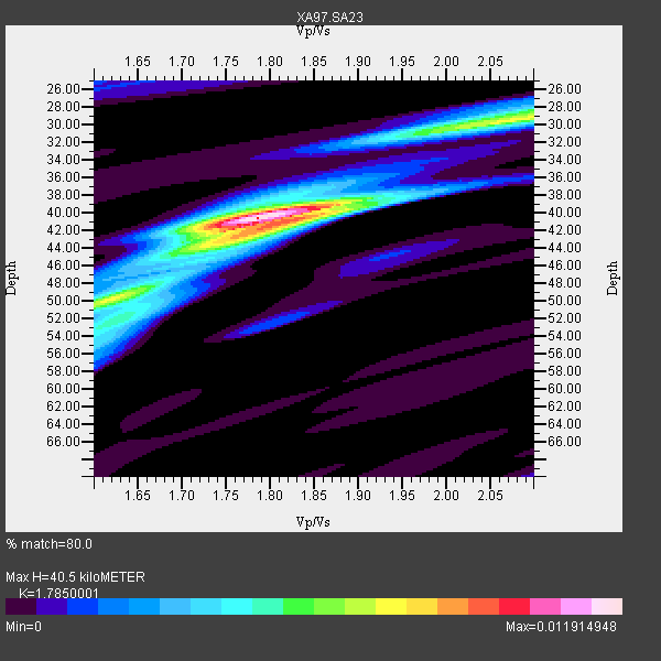
| Thickness Estimate: | 40 km |
| Thickness StdDev: | 6.8 km |
| Vp/Vs Estimate: | 1.79 |
| Vp/Vs StdDev: | 0.14 |
| Vs Estimate: | 3.704 km/s |
| Poisson's Ratio: | 0.27 |
| Peak Value: | 0.01 |
| Assumed Vp: | 6.612 km/s |
| Ps Weight: | 0.33333334 |
| PpPs Weight: | 0.33333334 |
| PsPs Weight: | 0.33333328 |
| Residual Complexity: | 0.561 |
| Nearby stations H: | +- |
| (2.0 deg) Vp/Vs: | +- |
2 with match > 90% ( 7.142857 %) and 8 with match > 80% ( 28.571428 %) out of 28.
Download stack as xyz text file.
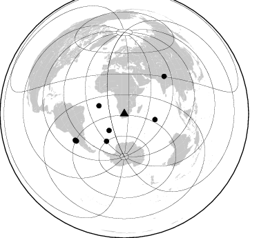
Azimuth Distribution of Events:
Prior Results for this Station
| Study | Thickness | Vp/Vs | Vp | Vs | Poissons Ratio | Extra |
| EARS | 40 km | 1.79 | 6.612 km/s | 3.704 km/s | 0.27 | |
| Crust2.0 | 42 km | 1.78 | 6.612 km/s | 3.71 km/s | 0.27 | I7,late Proter., 1 km seds. |
| Global Maxima | 40 km | 1.79 | 6.612 km/s | 3.704 km/s | 0.27 | amp=0.011914948 |
| Local Maxima 1 | 29 km | 2.09 | 6.612 km/s | 3.164 km/s | 0.35 | amp=0.0071426947 |
| Local Maxima 2 | 42 km | 1.79 | 6.612 km/s | 3.699 km/s | 0.27 | amp=0.0058092107 |
| Local Maxima 3 | 50 km | 1.60 | 6.612 km/s | 4.132 km/s | 0.18 | amp=0.004740865 |
| Local Maxima 4 | 54 km | 1.61 | 6.612 km/s | 4.113 km/s | 0.18 | amp=0.0028106146 |
| Predicted Arrivals for vertical incidence (zero ray parameter) | |
| Ps | 4.81 SECOND |
| PpPs | 17.06 SECOND |
| PsPs/PpSs | 21.87 SECOND |
Events Processed for this Station
Download zip of receiver functions as SAC
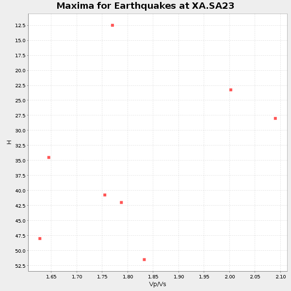
Plot maxima for each earthquake.
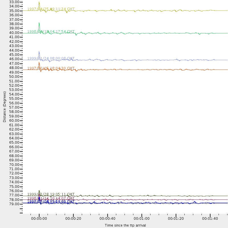
Events Used in the Stack
(8 events)| Radial Match | Distance | Baz | FERegion | Time | Lat/Lon | Depth | Magnitude |
| 97.62144 | 79.0 deg | 46.799 deg | Western Xizang-India Border Reg. | 1999/03/28 19:05:11 GMT | (30.5, 79.4) | 15 km | 6.4 MB, 6.6 MS, 6.6 MW, 6.5 ME |
| 93.61439 | 79.9 deg | 240.365 deg | Near Coast Of Central Chile | 1998/01/12 10:14:07 GMT | (-31.0, -71.4) | 35 km | 5.8 MB, 6.2 MS, 6.6 UNKNOWN, 6.2 ME |
| 87.52341 | 45.2 deg | 100.538 deg | Mid-Indian Ridge | 1999/01/24 08:00:08 GMT | (-26.5, 74.5) | 10 km | 6.0 MB, 6.3 MS, 6.3 MW, 6.3 ME |
| 86.69761 | 38.5 deg | 287.468 deg | Ascension Island Region | 1998/06/18 04:17:54 GMT | (-11.6, -13.9) | 10 km | 6.1 MS, 5.4 MB, 6.2 UNKNOWN |
| 84.10049 | 80.8 deg | 241.632 deg | Near Coast Of Central Chile | 1998/09/03 17:37:58 GMT | (-29.5, -71.7) | 27 km | 6.2 MB, 6.6 MS, 6.5 UNKNOWN, 6.4 ME |
| 83.20117 | 32.9 deg | 222.612 deg | Southern Mid-Atlantic Ridge | 1997/04/25 09:11:34 GMT | (-48.3, -10.0) | 10 km | 5.8 MS, 5.3 MB, 5.8 UNKNOWN, 5.7 MW |
| 82.732956 | 80.7 deg | 241.022 deg | Near Coast Of Central Chile | 1997/07/06 09:54:00 GMT | (-30.1, -71.9) | 19 km | 5.8 MB, 6.5 MS, 6.8 UNKNOWN, 6.4 ME |
| 80.98292 | 47.6 deg | 212.998 deg | South Sandwich Islands Region | 1997/10/05 18:04:30 GMT | (-59.7, -29.2) | 274 km | 6.0 MB, 6.3 UNKNOWN, 6.3 MW |
Losers
(20 events)| Radial Match | Distance | Baz | FERegion | Time | Lat/Lon | Depth | Magnitude | Reason |
| 92.685844 | 90.2 deg | 282.305 deg | Windward Islands | 1997/04/22 10:11:44 GMT | (11.0, -61.0) | 5.0 km | 5.6 MB | |
| 79.20796 | 70.3 deg | 20.636 deg | Armenia-Azerbaijan-Iran Bord Reg | 1998/07/09 14:19:18 GMT | (38.7, 48.5) | 26 km | 5.9 MB, 6.0 UNKNOWN, 5.7 ME | |
| 79.02374 | 84.9 deg | 169.977 deg | Balleny Islands Region | 1997/09/23 17:51:23 GMT | (-65.5, 178.8) | 10 km | 5.9 MS, 5.0 MB | |
| 79.02311 | 87.5 deg | 252.567 deg | Near Coast Of Peru | 1999/04/03 06:17:18 GMT | (-16.7, -72.7) | 87 km | 6.1 MB, 6.2 MS, 6.8 MW, 6.8 MW | |
| 76.77494 | 80.9 deg | 241.797 deg | Near Coast Of Central Chile | 1997/07/19 12:22:57 GMT | (-29.3, -71.7) | 26 km | 5.8 MB, 5.5 MS, 5.9 UNKNOWN, 5.8 MW | |
| 73.976456 | 79.2 deg | 239.206 deg | Near Coast Of Central Chile | 1998/07/29 07:14:24 GMT | (-32.3, -71.3) | 51 km | 6.3 MB, 6.5 UNKNOWN, 6.5 ME | |
| 73.631744 | 79.3 deg | 249.678 deg | Jujuy Province, Argentina | 1997/07/20 10:14:22 GMT | (-23.0, -66.3) | 256 km | 5.7 MB, 6.1 UNKNOWN, 5.7 ME | |
| 73.4721 | 78.2 deg | 37.502 deg | Afghanistan-Tajikistan Bord Reg. | 1998/02/20 12:18:06 GMT | (36.5, 71.1) | 236 km | 5.8 MB, 5.7 MS, 6.4 UNKNOWN, 6.3 MW | |
| 72.645805 | 95.8 deg | 193.718 deg | Pacific-Antarctic Ridge | 1997/10/26 13:55:33 GMT | (-54.1, -133.0) | 10 km | 5.5 MS, 5.1 MB | |
| 70.89295 | 94.7 deg | 187.638 deg | Pacific-Antarctic Ridge | 1998/10/11 23:36:22 GMT | (-56.9, -142.6) | 10 km | 5.2 MB, 5.7 MS, 6.3 UNKNOWN, 6.2 MW | |
| 68.585915 | 85.6 deg | 256.89 deg | Peru-Bolivia Border Region | 1997/11/28 22:53:41 GMT | (-13.7, -68.8) | 586 km | 6.4 MB, 6.6 UNKNOWN, 6.6 MW | |
| 67.978966 | 64.7 deg | 32.849 deg | Southern Iran | 1999/03/04 05:38:26 GMT | (28.3, 57.2) | 33 km | 6.2 MB, 6.5 MS, 6.6 MW, 6.4 MW | |
| 63.404945 | 76.0 deg | 77.719 deg | Northern Sumatra, Indonesia | 1999/02/04 19:28:00 GMT | (4.0, 95.3) | 56 km | 5.8 MB, 5.4 MS, 5.9 MW, 5.9 MW | |
| 62.028725 | 85.1 deg | 93.807 deg | Java Sea | 1997/07/11 09:55:12 GMT | (-5.7, 110.8) | 574 km | 5.6 MB | |
| 61.822243 | 45.8 deg | 298.461 deg | North Of Ascension Island | 1998/04/10 16:40:38 GMT | (-1.3, -15.7) | 10 km | 5.9 MS, 5.4 MB, 6.2 UNKNOWN, 6.1 MW | |
| 61.293076 | 73.9 deg | 17.629 deg | Eastern Caucasus | 1999/01/31 05:07:13 GMT | (43.2, 46.8) | 33 km | 5.8 MW, 5.4 MS, 5.3 MB, 5.7 MW | |
| 58.268402 | 65.1 deg | 80.905 deg | South Indian Ocean | 1999/03/29 06:17:58 GMT | (-4.0, 87.3) | 10 km | 5.5 MS, 5.4 MB, 5.8 MW, 5.8 MW | |
| 57.820103 | 89.2 deg | 99.293 deg | Sumbawa Region, Indonesia | 1997/10/23 01:16:01 GMT | (-8.7, 117.0) | 160 km | 5.5 MB | |
| 56.951324 | 86.7 deg | 253.612 deg | Southern Peru | 1998/10/08 04:51:42 GMT | (-16.1, -71.4) | 136 km | 6.1 MB, 6.4 UNKNOWN, 6.2 MW | |
| 35.738617 | 83.0 deg | 153.421 deg | West Of Macquarie Island | 1997/10/17 09:55:15 GMT | (-57.5, 148.0) | 10 km | 5.2 MB, 5.9 MS, 6.2 UNKNOWN, 6.0 MW |
