
Station XA SA25 - XA.SA25
Network: XA97 - Anatomy of an Archean Craton, South Africa
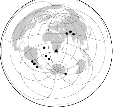
Nearby stations (2 deg radius)
| Station | Name | (Lat, Lon) | Start / End | Elevation |
| SA25 | XA.SA25 | (-27.85, 25.13) | 1997-04-14 / 1999-12-31 | 1253 m |
| Crust2 Type: | G1,Archean, no seds. |
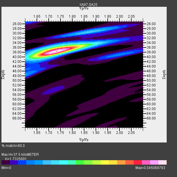
| Thickness Estimate: | 38 km |
| Thickness StdDev: | 0.6 km |
| Vp/Vs Estimate: | 1.73 |
| Vp/Vs StdDev: | 0.02 |
| Vs Estimate: | 3.728 km/s |
| Poisson's Ratio: | 0.25 |
| Peak Value: | 0.05 |
| Assumed Vp: | 6.459 km/s |
| Ps Weight: | 0.33333334 |
| PpPs Weight: | 0.33333334 |
| PsPs Weight: | 0.33333328 |
| Residual Complexity: | 0.441 |
| Nearby stations H: | +- |
| (2.0 deg) Vp/Vs: | +- |
8 with match > 90% ( 24.242424 %) and 13 with match > 80% ( 39.39394 %) out of 33.
Download stack as xyz text file.
Azimuth Distribution of Events:
Prior Results for this Station
| Study | Thickness | Vp/Vs | Vp | Vs | Poissons Ratio | Extra |
| EARS | 38 km | 1.73 | 6.459 km/s | 3.728 km/s | 0.25 | |
| Crust2.0 | 37 km | 1.76 | 6.459 km/s | 3.665 km/s | 0.26 | G1,Archean, no seds. |
| Global Maxima | 38 km | 1.73 | 6.459 km/s | 3.728 km/s | 0.25 | amp=0.045068793 |
| Local Maxima 1 | 36 km | 1.75 | 6.459 km/s | 3.691 km/s | 0.26 | amp=0.021050178 |
| Local Maxima 2 | 40 km | 1.69 | 6.459 km/s | 3.834 km/s | 0.23 | amp=0.013003868 |
| Local Maxima 3 | 30 km | 1.86 | 6.459 km/s | 3.473 km/s | 0.30 | amp=0.012177827 |
| Local Maxima 4 | 39 km | 2.00 | 6.459 km/s | 3.234 km/s | 0.33 | amp=0.008345807 |
| Predicted Arrivals for vertical incidence (zero ray parameter) | |
| Ps | 4.25 SECOND |
| PpPs | 15.86 SECOND |
| PsPs/PpSs | 20.12 SECOND |
Events Processed for this Station
Download zip of receiver functions as SAC
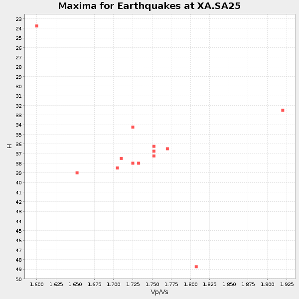
Plot maxima for each earthquake.
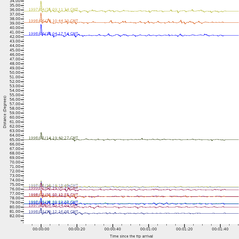
Events Used in the Stack
(13 events)| Radial Match | Distance | Baz | FERegion | Time | Lat/Lon | Depth | Magnitude |
| 98.740654 | 79.4 deg | 157.374 deg | Balleny Islands Region | 1998/03/25 03:12:25 GMT | (-62.9, 149.5) | 10 km | 6.6 MB, 8.0 MS, 8.3 UNKNOWN, 8.1 MW |
| 97.59454 | 81.2 deg | 239.8 deg | Near Coast Of Central Chile | 1997/10/15 01:03:33 GMT | (-30.9, -71.2) | 58 km | 6.8 MB, 6.8 MS, 7.3 UNKNOWN, 7.1 MW |
| 96.4067 | 83.6 deg | 246.487 deg | Near Coast Of Northern Chile | 1998/01/30 12:16:08 GMT | (-23.9, -70.2) | 42 km | 6.3 MB, 6.5 MS, 7.0 UNKNOWN, 6.7 ME |
| 94.32707 | 77.8 deg | 45.794 deg | Western Xizang-India Border Reg. | 1999/03/28 19:05:11 GMT | (30.5, 79.4) | 15 km | 6.4 MB, 6.6 MS, 6.6 MW, 6.5 ME |
| 94.32194 | 77.1 deg | 36.404 deg | Hindu Kush Region, Afghanistan | 1997/05/13 14:13:45 GMT | (36.4, 70.9) | 196 km | 6.1 MB, 6.5 UNKNOWN, 6.4 MW |
| 93.870346 | 79.5 deg | 229.977 deg | Off Coast Of Southern Chile | 1998/04/01 22:42:56 GMT | (-40.3, -74.9) | 9.0 km | 6.2 MB, 6.0 MS, 6.7 UNKNOWN, 6.6 ME |
| 93.36086 | 65.5 deg | 30.74 deg | Northern And Central Iran | 1998/03/14 19:40:27 GMT | (30.2, 57.6) | 9.0 km | 5.9 MB, 6.9 MS, 6.6 UNKNOWN, 6.3 ME |
| 93.010185 | 81.3 deg | 239.678 deg | Near Coast Of Central Chile | 1998/01/12 10:14:07 GMT | (-31.0, -71.4) | 35 km | 5.8 MB, 6.2 MS, 6.6 UNKNOWN, 6.2 ME |
| 88.31242 | 39.9 deg | 286.03 deg | Ascension Island Region | 1998/06/18 04:17:54 GMT | (-11.6, -13.9) | 10 km | 6.1 MS, 5.4 MB, 6.2 UNKNOWN |
| 82.670044 | 34.0 deg | 223.41 deg | Southern Mid-Atlantic Ridge | 1997/04/25 09:11:34 GMT | (-48.3, -10.0) | 10 km | 5.8 MS, 5.3 MB, 5.8 UNKNOWN, 5.7 MW |
| 82.42468 | 82.1 deg | 240.323 deg | Near Coast Of Central Chile | 1997/07/06 09:54:00 GMT | (-30.1, -71.9) | 19 km | 5.8 MB, 6.5 MS, 6.8 UNKNOWN, 6.4 ME |
| 81.61854 | 36.8 deg | 244.148 deg | Southern Mid-Atlantic Ridge | 1998/06/24 10:44:30 GMT | (-37.3, -17.4) | 10 km | 5.7 MB, 5.8 MS, 6.0 UNKNOWN, 5.9 MW |
| 81.2556 | 77.2 deg | 36.447 deg | Afghanistan-Tajikistan Bord Reg. | 1998/02/20 12:18:06 GMT | (36.5, 71.1) | 236 km | 5.8 MB, 5.7 MS, 6.4 UNKNOWN, 6.3 MW |
Losers
(20 events)| Radial Match | Distance | Baz | FERegion | Time | Lat/Lon | Depth | Magnitude | Reason |
| 84.88708 | 96.0 deg | 190.727 deg | Pacific-Antarctic Ridge | 1997/05/27 06:10:31 GMT | (-54.9, -136.2) | 10 km | 5.9 MS, 5.3 MB, 6.1 UNKNOWN, 6.0 MW | |
| 77.51219 | 77.0 deg | 36.27 deg | Hindu Kush Region, Afghanistan | 1999/06/21 17:37:27 GMT | (36.4, 70.7) | 230 km | 5.6 MW, 5.4 MB, 5.5 MW | |
| 75.09698 | 81.9 deg | 239.948 deg | Near Coast Of Central Chile | 1997/07/25 06:47:02 GMT | (-30.5, -71.9) | 33 km | 5.6 MB, 5.5 MS, 6.3 UNKNOWN | |
| 74.28404 | 35.8 deg | 247.18 deg | Southern Mid-Atlantic Ridge | 1998/01/03 06:10:08 GMT | (-35.5, -16.2) | 10 km | 5.9 MS, 5.4 MB, 6.3 UNKNOWN, 6.1 MW | |
| 73.15156 | 80.6 deg | 238.533 deg | Near Coast Of Central Chile | 1998/07/29 07:14:24 GMT | (-32.3, -71.3) | 51 km | 6.3 MB, 6.5 UNKNOWN, 6.5 ME | |
| 72.00513 | 48.5 deg | 213.302 deg | South Sandwich Islands Region | 1997/10/05 18:04:30 GMT | (-59.7, -29.2) | 274 km | 6.0 MB, 6.3 UNKNOWN, 6.3 MW | |
| 70.75164 | 97.1 deg | 92.36 deg | Minahassa Peninsula, Sulawesi | 1997/11/25 12:14:33 GMT | (1.2, 122.5) | 24 km | 6.1 MB, 6.8 MS, 7.1 UNKNOWN, 6.7 ME | |
| 69.95194 | 77.2 deg | 36.383 deg | Afghanistan-Tajikistan Bord Reg. | 1998/12/11 20:16:24 GMT | (36.5, 71.0) | 223 km | 5.7 UNKNOWN, 5.0 MB, 5.6 MW | |
| 66.57423 | 47.1 deg | 296.915 deg | North Of Ascension Island | 1998/04/10 16:40:38 GMT | (-1.3, -15.7) | 10 km | 5.9 MS, 5.4 MB, 6.2 UNKNOWN, 6.1 MW | |
| 65.66995 | 77.8 deg | 233.253 deg | S. Chile-Argentina Border Region | 1998/12/14 16:25:24 GMT | (-38.2, -71.0) | 138 km | 6.0 UNKNOWN, 4.8 MS, 5.4 MB | |
| 65.259514 | 88.2 deg | 252.827 deg | Southern Peru | 1998/10/08 04:51:42 GMT | (-16.1, -71.4) | 136 km | 6.1 MB, 6.4 UNKNOWN, 6.2 MW | |
| 64.28291 | 83.5 deg | 93.023 deg | Java Sea | 1997/07/11 09:55:12 GMT | (-5.7, 110.8) | 574 km | 5.6 MB | |
| 58.52744 | 87.1 deg | 256.106 deg | Peru-Bolivia Border Region | 1997/11/28 22:53:41 GMT | (-13.7, -68.8) | 586 km | 6.4 MB, 6.6 UNKNOWN, 6.6 MW | |
| 57.662956 | 82.3 deg | 241.093 deg | Near Coast Of Central Chile | 1997/07/19 12:22:57 GMT | (-29.3, -71.7) | 26 km | 5.8 MB, 5.5 MS, 5.9 UNKNOWN, 5.8 MW | |
| 56.409306 | 82.8 deg | 248.575 deg | Northern Chile | 1997/09/28 23:13:13 GMT | (-22.4, -68.4) | 107 km | 5.7 MB, 5.6 UNKNOWN, 5.6 MW | |
| 55.738403 | 63.6 deg | 80.022 deg | South Indian Ocean | 1999/03/29 06:17:58 GMT | (-4.0, 87.3) | 10 km | 5.5 MS, 5.4 MB, 5.8 MW, 5.8 MW | |
| 55.691254 | 80.8 deg | 248.957 deg | Jujuy Province, Argentina | 1997/07/20 10:14:22 GMT | (-23.0, -66.3) | 256 km | 5.7 MB, 6.1 UNKNOWN, 5.7 ME | |
| 54.117874 | 88.5 deg | 97.092 deg | Bali Sea | 1999/03/24 20:32:59 GMT | (-7.0, 117.1) | 621 km | 5.9 MW, 5.3 MB | |
| 49.75851 | 81.5 deg | 243.878 deg | Northern Chile | 1997/05/17 02:10:18 GMT | (-27.2, -69.5) | 106 km | 5.5 MB, 5.6 UNKNOWN, 5.5 MW | |
| 49.151382 | 83.7 deg | 250.547 deg | Chile-Bolivia Border Region | 1997/12/09 14:23:45 GMT | (-20.2, -68.4) | 133 km | 5.7 MB, 5.7 UNKNOWN, 5.7 MW |
