
Station XA SA26 - XA.SA26
Network: XA97 - Anatomy of an Archean Craton, South Africa
Nearby stations (2 deg radius)
| Station | Name | (Lat, Lon) | Start / End | Elevation |
| SA26 | XA.SA26 | (-27.55, 26.18) | 1998-05-18 / 1999-12-31 | 1300 m |
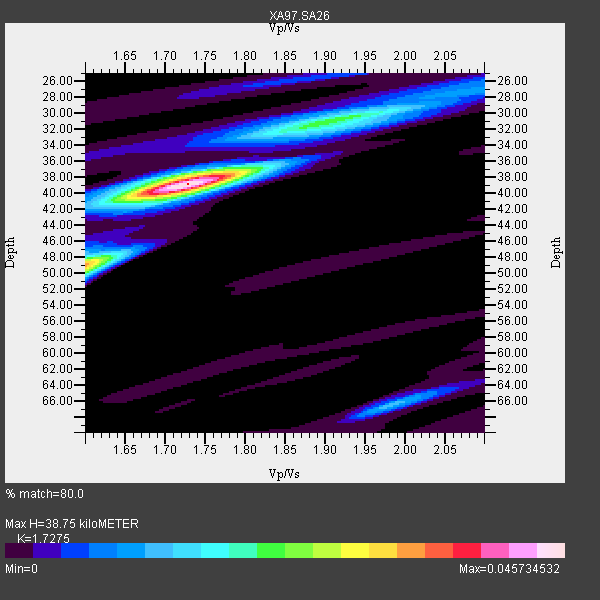
| Crust2 Type: | G1,Archean, no seds. |
| Thickness Estimate: | 39 km |
| Thickness StdDev: | 5.3 km |
| Vp/Vs Estimate: | 1.73 |
| Vp/Vs StdDev: | 0.07 |
| Vs Estimate: | 3.739 km/s |
| Poisson's Ratio: | 0.25 |
| Peak Value: | 0.05 |
| Assumed Vp: | 6.459 km/s |
| Ps Weight: | 0.33333334 |
| PpPs Weight: | 0.33333334 |
| PsPs Weight: | 0.33333328 |
| Residual Complexity: | 0.509 |
| Nearby stations H: | +- |
| (2.0 deg) Vp/Vs: | +- |
1 with match > 90% ( 7.6923075 %) and 4 with match > 80% ( 30.76923 %) out of 13.
Download stack as xyz text file.
Azimuth Distribution of Events:

Prior Results for this Station
| Study | Thickness | Vp/Vs | Vp | Vs | Poissons Ratio | Extra |
| EARS | 39 km | 1.73 | 6.459 km/s | 3.739 km/s | 0.25 | |
| Crust2.0 | 37 km | 1.76 | 6.459 km/s | 3.665 km/s | 0.26 | G1,Archean, no seds. |
| Global Maxima | 39 km | 1.73 | 6.459 km/s | 3.739 km/s | 0.25 | amp=0.045734532 |
| Local Maxima 1 | 49 km | 1.60 | 6.459 km/s | 4.037 km/s | 0.18 | amp=0.03159995 |
| Local Maxima 2 | 31 km | 1.89 | 6.459 km/s | 3.409 km/s | 0.31 | amp=0.017561035 |
| Local Maxima 3 | 66 km | 1.99 | 6.459 km/s | 3.254 km/s | 0.33 | amp=0.012234501 |
| Local Maxima 4 | 38 km | 1.72 | 6.459 km/s | 3.766 km/s | 0.24 | amp=0.009546287 |
| Predicted Arrivals for vertical incidence (zero ray parameter) | |
| Ps | 4.36 SECOND |
| PpPs | 16.36 SECOND |
| PsPs/PpSs | 20.73 SECOND |
Events Processed for this Station
Download zip of receiver functions as SAC
Plot maxima for each earthquake.
Events Used in the Stack
(4 events)| Radial Match | Distance | Baz | FERegion | Time | Lat/Lon | Depth | Magnitude |
| 94.702484 | 76.9 deg | 45.208 deg | Western Xizang-India Border Reg. | 1999/03/28 19:05:11 GMT | (30.5, 79.4) | 15 km | 6.4 MB, 6.6 MS, 6.6 MW, 6.5 ME |
| 88.05193 | 83.2 deg | 240.467 deg | Near Coast Of Central Chile | 1998/09/03 17:37:58 GMT | (-29.5, -71.7) | 27 km | 6.2 MB, 6.6 MS, 6.5 UNKNOWN, 6.4 ME |
| 82.580475 | 42.8 deg | 100.099 deg | Mid-Indian Ridge | 1999/01/24 08:00:08 GMT | (-26.5, 74.5) | 10 km | 6.0 MB, 6.3 MS, 6.3 MW, 6.3 ME |
| 82.08779 | 47.2 deg | 218.161 deg | South Sandwich Islands Region | 1998/08/29 08:30:21 GMT | (-55.7, -27.0) | 33 km | 5.6 MB, 5.6 MS, 6.0 UNKNOWN, 5.9 MW |
Losers
(9 events)| Radial Match | Distance | Baz | FERegion | Time | Lat/Lon | Depth | Magnitude | Reason |
| 77.23199 | 40.8 deg | 284.91 deg | Ascension Island Region | 1998/06/18 04:17:54 GMT | (-11.6, -13.9) | 10 km | 6.1 MS, 5.4 MB, 6.2 UNKNOWN | |
| 76.89445 | 37.8 deg | 243.846 deg | Southern Mid-Atlantic Ridge | 1998/06/24 10:44:30 GMT | (-37.3, -17.4) | 10 km | 5.7 MB, 5.8 MS, 6.0 UNKNOWN, 5.9 MW | |
| 64.50337 | 76.4 deg | 35.76 deg | Afghanistan-Tajikistan Bord Reg. | 1998/12/11 20:16:24 GMT | (36.5, 71.0) | 223 km | 5.7 UNKNOWN, 5.0 MB, 5.6 MW | |
| 62.33085 | 83.7 deg | 247.796 deg | Northern Chile | 1999/03/02 17:45:55 GMT | (-22.7, -68.5) | 111 km | 5.8 MB, 6.1 MW, 5.9 MW | |
| 54.667328 | 72.9 deg | 15.674 deg | Eastern Caucasus | 1999/01/31 05:07:13 GMT | (43.2, 46.8) | 33 km | 5.8 MW, 5.4 MS, 5.3 MB, 5.7 MW | |
| 51.731014 | 90.4 deg | 100.46 deg | Savu Sea | 1998/11/08 07:25:48 GMT | (-9.1, 121.4) | 33 km | 6.0 MB, 5.9 MS, 6.4 UNKNOWN, 5.7 ME | |
| 50.146782 | 78.7 deg | 232.832 deg | S. Chile-Argentina Border Region | 1998/12/14 16:25:24 GMT | (-38.2, -71.0) | 138 km | 6.0 UNKNOWN, 4.8 MS, 5.4 MB | |
| 49.09425 | 63.0 deg | 30.635 deg | Southern Iran | 1999/03/04 05:38:26 GMT | (28.3, 57.2) | 33 km | 6.2 MB, 6.5 MS, 6.6 MW, 6.4 MW | |
| 48.946877 | 89.2 deg | 252.339 deg | Southern Peru | 1998/10/08 04:51:42 GMT | (-16.1, -71.4) | 136 km | 6.1 MB, 6.4 UNKNOWN, 6.2 MW |
