
Station XA SA27 - XA.SA27
Network: XA97 - Anatomy of an Archean Craton, South Africa
Nearby stations (2 deg radius)
| Station | Name | (Lat, Lon) | Start / End | Elevation |
| SA27 | XA.SA27 | (-27.86, 27.29) | 1998-04-04 / 1999-12-31 | 1400 m |
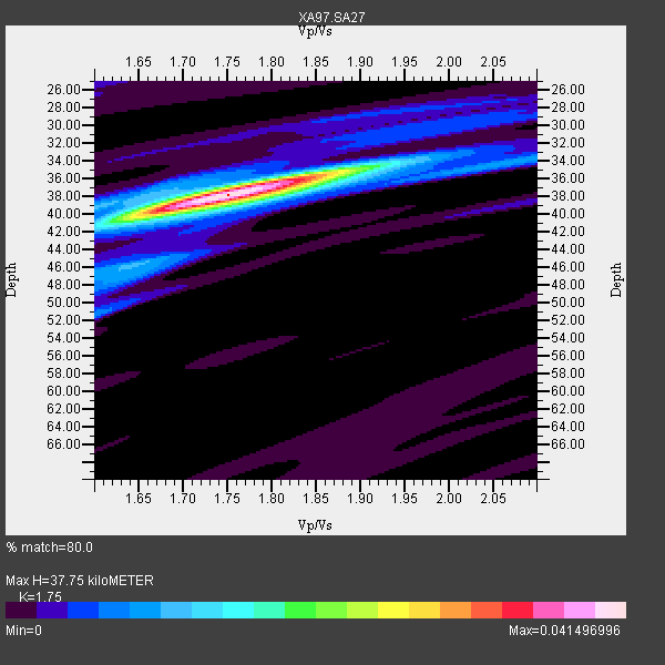
| Crust2 Type: | G1,Archean, no seds. |
| Thickness Estimate: | 38 km |
| Thickness StdDev: | 1.0 km |
| Vp/Vs Estimate: | 1.75 |
| Vp/Vs StdDev: | 0.07 |
| Vs Estimate: | 3.691 km/s |
| Poisson's Ratio: | 0.26 |
| Peak Value: | 0.04 |
| Assumed Vp: | 6.459 km/s |
| Ps Weight: | 0.33333334 |
| PpPs Weight: | 0.33333334 |
| PsPs Weight: | 0.33333328 |
| Residual Complexity: | 0.337 |
| Nearby stations H: | +- |
| (2.0 deg) Vp/Vs: | +- |
1 with match > 90% ( 5.0 %) and 5 with match > 80% ( 25.0 %) out of 20.
Download stack as xyz text file.
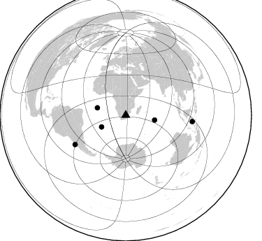
Azimuth Distribution of Events:
Prior Results for this Station
| Study | Thickness | Vp/Vs | Vp | Vs | Poissons Ratio | Extra |
| EARS | 38 km | 1.75 | 6.459 km/s | 3.691 km/s | 0.26 | |
| Crust2.0 | 37 km | 1.76 | 6.459 km/s | 3.665 km/s | 0.26 | G1,Archean, no seds. |
| Global Maxima | 38 km | 1.75 | 6.459 km/s | 3.691 km/s | 0.26 | amp=0.041496996 |
| Local Maxima 1 | 35 km | 1.86 | 6.459 km/s | 3.473 km/s | 0.30 | amp=0.015509116 |
| Local Maxima 2 | 40 km | 1.65 | 6.459 km/s | 3.915 km/s | 0.21 | amp=0.01078279 |
| Local Maxima 3 | 51 km | 1.60 | 6.459 km/s | 4.037 km/s | 0.18 | amp=0.007994692 |
| Local Maxima 4 | 46 km | 1.65 | 6.459 km/s | 3.915 km/s | 0.21 | amp=0.0069258544 |
| Predicted Arrivals for vertical incidence (zero ray parameter) | |
| Ps | 4.38 SECOND |
| PpPs | 16.07 SECOND |
| PsPs/PpSs | 20.45 SECOND |
Events Processed for this Station
Download zip of receiver functions as SAC
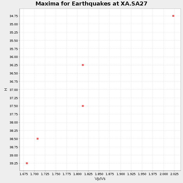
Plot maxima for each earthquake.
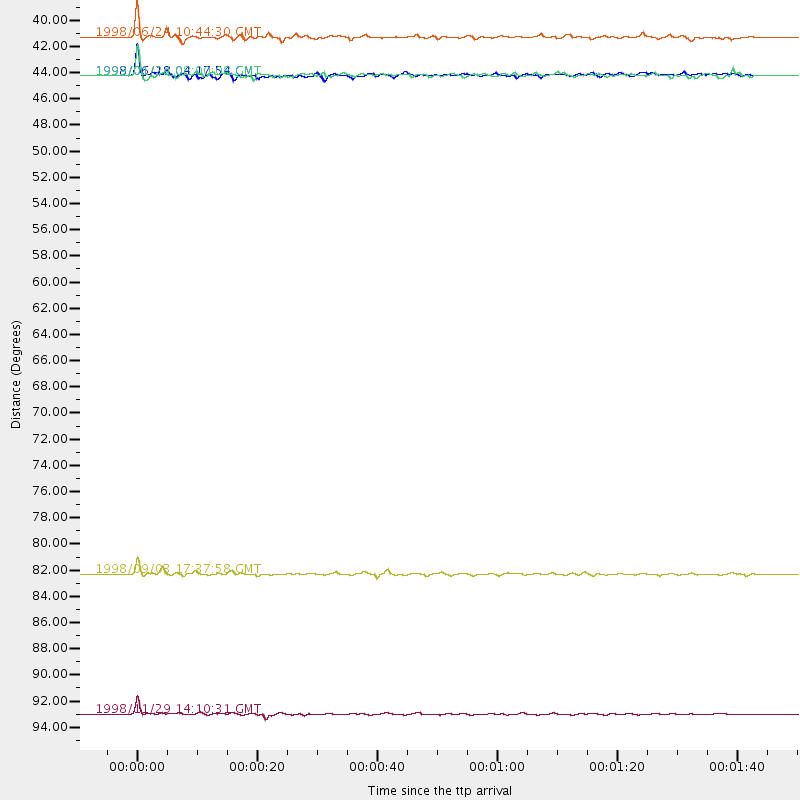
Events Used in the Stack
(5 events)| Radial Match | Distance | Baz | FERegion | Time | Lat/Lon | Depth | Magnitude |
| 94.496925 | 95.8 deg | 95.375 deg | Ceram Sea | 1998/11/29 14:10:31 GMT | (-2.1, 124.9) | 33 km | 6.5 MB, 7.7 MS, 8.1 UNKNOWN, 7.8 MW |
| 83.98418 | 38.5 deg | 244.243 deg | Southern Mid-Atlantic Ridge | 1998/06/24 10:44:30 GMT | (-37.3, -17.4) | 10 km | 5.7 MB, 5.8 MS, 6.0 UNKNOWN, 5.9 MW |
| 83.50038 | 41.8 deg | 99.426 deg | Mid-Indian Ridge | 1999/01/24 08:00:08 GMT | (-26.5, 74.5) | 10 km | 6.0 MB, 6.3 MS, 6.3 MW, 6.3 ME |
| 82.383255 | 83.9 deg | 240.038 deg | Near Coast Of Central Chile | 1998/09/03 17:37:58 GMT | (-29.5, -71.7) | 27 km | 6.2 MB, 6.6 MS, 6.5 UNKNOWN, 6.4 ME |
| 81.6946 | 41.8 deg | 284.457 deg | Ascension Island Region | 1998/06/18 04:17:54 GMT | (-11.6, -13.9) | 10 km | 6.1 MS, 5.4 MB, 6.2 UNKNOWN |
Losers
(15 events)| Radial Match | Distance | Baz | FERegion | Time | Lat/Lon | Depth | Magnitude | Reason |
| 78.90512 | 75.9 deg | 34.882 deg | Hindu Kush Region, Afghanistan | 1999/06/21 17:37:27 GMT | (36.4, 70.7) | 230 km | 5.6 MW, 5.4 MB, 5.5 MW | |
| 78.38562 | 97.9 deg | 221.95 deg | West Chile Rise | 1998/09/07 00:39:30 GMT | (-36.2, -97.7) | 10 km | 5.2 MB, 5.7 MS, 6.2 UNKNOWN, 6.1 MW | |
| 72.964775 | 89.4 deg | 99.944 deg | Savu Sea | 1998/11/08 07:25:48 GMT | (-9.1, 121.4) | 33 km | 6.0 MB, 5.9 MS, 6.4 UNKNOWN, 5.7 ME | |
| 72.169464 | 47.5 deg | 218.54 deg | South Sandwich Islands Region | 1998/08/29 08:30:21 GMT | (-55.7, -27.0) | 33 km | 5.6 MB, 5.6 MS, 6.0 UNKNOWN, 5.9 MW | |
| 71.51477 | 76.1 deg | 35.003 deg | Afghanistan-Tajikistan Bord Reg. | 1998/12/11 20:16:24 GMT | (36.5, 71.0) | 223 km | 5.7 UNKNOWN, 5.0 MB, 5.6 MW | |
| 69.11611 | 67.7 deg | 349.799 deg | Southern Italy | 1998/05/18 17:19:04 GMT | (39.3, 15.1) | 280 km | 5.6 MB | |
| 64.42343 | 72.6 deg | 75.704 deg | Northern Sumatra, Indonesia | 1999/02/04 19:28:00 GMT | (4.0, 95.3) | 56 km | 5.8 MB, 5.4 MS, 5.9 MW, 5.9 MW | |
| 63.648357 | 79.3 deg | 232.482 deg | S. Chile-Argentina Border Region | 1998/12/14 16:25:24 GMT | (-38.2, -71.0) | 138 km | 6.0 UNKNOWN, 4.8 MS, 5.4 MB | |
| 56.767803 | 82.6 deg | 248.308 deg | Jujuy Province, Argentina | 1999/06/09 23:25:01 GMT | (-22.8, -66.2) | 250 km | 5.5 MW, 5.3 MB | |
| 56.69508 | 92.1 deg | 91.539 deg | Minahassa Peninsula, Sulawesi | 1998/10/10 16:32:19 GMT | (-0.4, 119.8) | 33 km | 5.7 MB, 5.6 MS, 6.0 UNKNOWN, 6.0 MW | |
| 53.024773 | 84.3 deg | 319.325 deg | Azores Islands, Portugal | 1998/07/09 05:19:07 GMT | (38.7, -28.6) | 10 km | 5.7 MB, 6.0 MS, 6.6 UNKNOWN, 6.2 MW | |
| 50.226475 | 48.8 deg | 295.16 deg | North Of Ascension Island | 1998/04/10 16:40:38 GMT | (-1.3, -15.7) | 10 km | 5.9 MS, 5.4 MB, 6.2 UNKNOWN, 6.1 MW | |
| 47.68537 | 95.5 deg | 92.84 deg | Minahassa Peninsula, Sulawesi | 1999/06/02 00:23:19 GMT | (0.1, 123.5) | 161 km | 5.8 MB, 5.6 MW | |
| 47.315166 | 90.0 deg | 251.828 deg | Southern Peru | 1998/10/08 04:51:42 GMT | (-16.1, -71.4) | 136 km | 6.1 MB, 6.4 UNKNOWN, 6.2 MW | |
| 44.894257 | 80.8 deg | 238.608 deg | Mendoza Province, Argentina | 1998/11/27 10:27:02 GMT | (-32.1, -69.3) | 127 km | 5.2 MB, 5.5 UNKNOWN, 5.3 MD |
