
Station XA SA28 - XA.SA28
Network: XA97 - Anatomy of an Archean Craton, South Africa
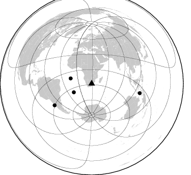
Nearby stations (2 deg radius)
| Station | Name | (Lat, Lon) | Start / End | Elevation |
| SA28 | XA.SA28 | (-27.90, 28.07) | 1998-05-19 / 1999-12-31 | 1600 m |
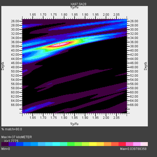
| Crust2 Type: | G1,Archean, no seds. |
| Thickness Estimate: | 37 km |
| Thickness StdDev: | 2.9 km |
| Vp/Vs Estimate: | 1.78 |
| Vp/Vs StdDev: | 0.05 |
| Vs Estimate: | 3.634 km/s |
| Poisson's Ratio: | 0.27 |
| Peak Value: | 0.04 |
| Assumed Vp: | 6.459 km/s |
| Ps Weight: | 0.33333334 |
| PpPs Weight: | 0.33333334 |
| PsPs Weight: | 0.33333328 |
| Residual Complexity: | 0.378 |
| Nearby stations H: | +- |
| (2.0 deg) Vp/Vs: | +- |
0 with match > 90% ( 0.0 %) and 4 with match > 80% ( 19.047619 %) out of 21.
Download stack as xyz text file.
Azimuth Distribution of Events:
Prior Results for this Station
| Study | Thickness | Vp/Vs | Vp | Vs | Poissons Ratio | Extra |
| EARS | 37 km | 1.78 | 6.459 km/s | 3.634 km/s | 0.27 | |
| Crust2.0 | 37 km | 1.76 | 6.459 km/s | 3.665 km/s | 0.26 | G1,Archean, no seds. |
| Global Maxima | 37 km | 1.78 | 6.459 km/s | 3.634 km/s | 0.27 | amp=0.039788358 |
| Local Maxima 1 | 38 km | 1.76 | 6.459 km/s | 3.66 km/s | 0.26 | amp=0.014605033 |
| Local Maxima 2 | 34 km | 1.89 | 6.459 km/s | 3.422 km/s | 0.30 | amp=0.011479095 |
| Local Maxima 3 | 43 km | 1.64 | 6.459 km/s | 3.933 km/s | 0.21 | amp=0.009644292 |
| Local Maxima 4 | 37 km | 1.62 | 6.459 km/s | 3.975 km/s | 0.20 | amp=0.008117022 |
| Predicted Arrivals for vertical incidence (zero ray parameter) | |
| Ps | 4.45 SECOND |
| PpPs | 15.91 SECOND |
| PsPs/PpSs | 20.36 SECOND |
Events Processed for this Station
Download zip of receiver functions as SAC
Plot maxima for each earthquake.
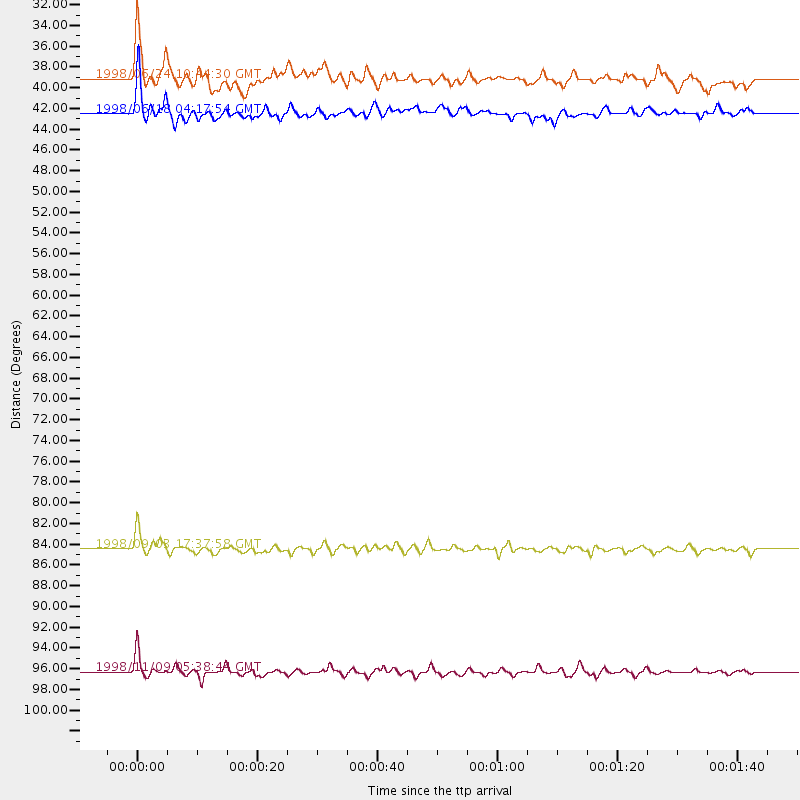
Events Used in the Stack
(4 events)| Radial Match | Distance | Baz | FERegion | Time | Lat/Lon | Depth | Magnitude |
| 85.7744 | 84.5 deg | 239.718 deg | Near Coast Of Central Chile | 1998/09/03 17:37:58 GMT | (-29.5, -71.7) | 27 km | 6.2 MB, 6.6 MS, 6.5 UNKNOWN, 6.4 ME |
| 83.94933 | 39.1 deg | 244.293 deg | Southern Mid-Atlantic Ridge | 1998/06/24 10:44:30 GMT | (-37.3, -17.4) | 10 km | 5.7 MB, 5.8 MS, 6.0 UNKNOWN, 5.9 MW |
| 81.77819 | 96.3 deg | 101.206 deg | Banda Sea | 1998/11/09 05:38:44 GMT | (-6.9, 128.9) | 33 km | 6.4 MB, 7.0 MS, 7.3 UNKNOWN, 7.0 MW |
| 81.044205 | 42.5 deg | 283.951 deg | Ascension Island Region | 1998/06/18 04:17:54 GMT | (-11.6, -13.9) | 10 km | 6.1 MS, 5.4 MB, 6.2 UNKNOWN |
Losers
(17 events)| Radial Match | Distance | Baz | FERegion | Time | Lat/Lon | Depth | Magnitude | Reason |
| 99.80149 | 95.5 deg | 92.947 deg | Southern Molucca Sea | 1999/03/18 01:59:00 GMT | (-0.0, 124.3) | 88 km | 5.5 MB, 5.1 MS, 5.8 MW, 5.8 MW | |
| 99.788475 | 61.0 deg | 78.372 deg | South Indian Ocean | 1999/03/29 06:17:58 GMT | (-4.0, 87.3) | 10 km | 5.5 MS, 5.4 MB, 5.8 MW, 5.8 MW | |
| 80.93946 | 96.1 deg | 87.27 deg | Celebes Sea | 1999/03/05 13:01:10 GMT | (5.3, 122.2) | 33 km | 5.6 MB, 5.1 MS, 5.7 MW, 5.7 MW | |
| 75.39118 | 82.8 deg | 237.374 deg | Near Coast Of Central Chile | 1998/07/29 07:14:24 GMT | (-32.3, -71.3) | 51 km | 6.3 MB, 6.5 UNKNOWN, 6.5 ME | |
| 72.38243 | 85.1 deg | 247.019 deg | Northern Chile | 1999/03/02 17:45:55 GMT | (-22.7, -68.5) | 111 km | 5.8 MB, 6.1 MW, 5.9 MW | |
| 67.15964 | 95.9 deg | 87.038 deg | Celebes Sea | 1999/03/04 08:52:01 GMT | (5.4, 121.9) | 33 km | 6.4 MB, 6.5 MS, 7.1 MW, 7.1 MW | |
| 62.56816 | 96.4 deg | 101.273 deg | Banda Sea | 1998/11/09 05:30:14 GMT | (-7.0, 129.0) | 33 km | 6.1 MB, 6.7 UNKNOWN, 6.6 ME | |
| 60.357002 | 80.5 deg | 239.456 deg | San Juan Province, Argentina | 1998/06/07 16:10:46 GMT | (-31.5, -67.8) | 113 km | 5.6 MB, 5.9 UNKNOWN, 5.9 MW | |
| 51.072105 | 91.4 deg | 90.511 deg | Minahassa Peninsula, Sulawesi | 1999/02/23 07:27:56 GMT | (0.2, 119.5) | 33 km | 5.6 MB, 5.8 MS | |
| 42.378704 | 86.5 deg | 248.86 deg | Chile-Bolivia Border Region | 1999/03/05 00:33:46 GMT | (-20.4, -68.9) | 111 km | 5.7 MB, 5.9 MW, 5.8 MW | |
| 40.952736 | 73.1 deg | 34.831 deg | Southeastern Afghanistan | 1999/02/11 14:08:51 GMT | (34.3, 69.4) | 33 km | 5.8 MS, 5.4 MB, 6.0 MW, 6.0 MW | |
| 40.17997 | 81.3 deg | 49.438 deg | Xizang | 1998/08/25 07:41:40 GMT | (30.1, 88.1) | 33 km | 5.5 MS, 5.3 MB, 5.7 UNKNOWN | |
| 38.176517 | 89.2 deg | 153.197 deg | Macquarie Island Region | 1998/06/16 09:35:11 GMT | (-53.0, 159.8) | 10 km | 5.7 MS, 4.9 MB, 6.2 UNKNOWN, 6.1 MW | |
| 34.576885 | 72.8 deg | 14.275 deg | Eastern Caucasus | 1999/01/31 05:07:13 GMT | (43.2, 46.8) | 33 km | 5.8 MW, 5.4 MS, 5.3 MB, 5.7 MW | |
| 26.303282 | 47.9 deg | 218.687 deg | South Sandwich Islands Region | 1998/08/29 08:30:21 GMT | (-55.7, -27.0) | 33 km | 5.6 MB, 5.6 MS, 6.0 UNKNOWN, 5.9 MW | |
| 25.962162 | 90.7 deg | 251.468 deg | Southern Peru | 1998/10/08 04:51:42 GMT | (-16.1, -71.4) | 136 km | 6.1 MB, 6.4 UNKNOWN, 6.2 MW | |
| 20.315783 | 96.6 deg | 189.509 deg | Pacific-Antarctic Ridge | 1998/08/05 12:54:25 GMT | (-54.7, -135.5) | 10 km | 5.9 MS, 5.2 MB, 6.2 UNKNOWN, 6.0 MW |
