
Station XA SA37 - XA.SA37
Network: XA97 - Anatomy of an Archean Craton, South Africa
Nearby stations (2 deg radius)
| Station | Name | (Lat, Lon) | Start / End | Elevation |
| SA37 | XA.SA37 | (-25.97, 23.72) | 1997-04-20 / 1999-12-31 | 1142 m |
| Crust2 Type: | I7,late Proter., 1 km seds. |
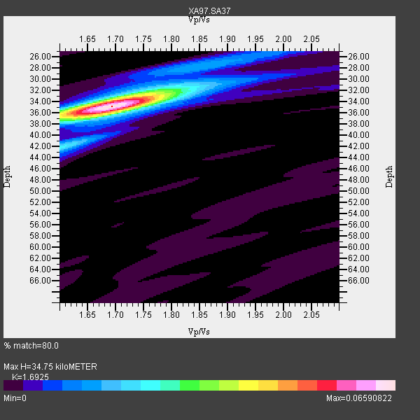
| Thickness Estimate: | 35 km |
| Thickness StdDev: | 0.3 km |
| Vp/Vs Estimate: | 1.69 |
| Vp/Vs StdDev: | 0.01 |
| Vs Estimate: | 3.907 km/s |
| Poisson's Ratio: | 0.23 |
| Peak Value: | 0.07 |
| Assumed Vp: | 6.612 km/s |
| Ps Weight: | 0.33333334 |
| PpPs Weight: | 0.33333334 |
| PsPs Weight: | 0.33333328 |
| Residual Complexity: | 0.378 |
| Nearby stations H: | +- |
| (2.0 deg) Vp/Vs: | +- |
6 with match > 90% ( 24.0 %) and 10 with match > 80% ( 40.0 %) out of 25.
Download stack as xyz text file.
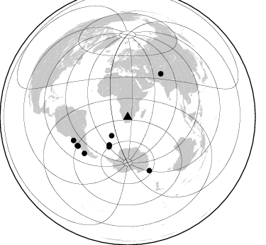
Azimuth Distribution of Events:
Prior Results for this Station
| Study | Thickness | Vp/Vs | Vp | Vs | Poissons Ratio | Extra |
| EARS | 35 km | 1.69 | 6.612 km/s | 3.907 km/s | 0.23 | |
| Crust2.0 | 42 km | 1.78 | 6.612 km/s | 3.71 km/s | 0.27 | I7,late Proter., 1 km seds. |
| Global Maxima | 35 km | 1.69 | 6.612 km/s | 3.907 km/s | 0.23 | amp=0.06590822 |
| Local Maxima 1 | 32 km | 1.75 | 6.612 km/s | 3.778 km/s | 0.26 | amp=0.02754112 |
| Local Maxima 2 | 42 km | 1.60 | 6.612 km/s | 4.126 km/s | 0.18 | amp=0.021814855 |
| Local Maxima 3 | 36 km | 1.69 | 6.612 km/s | 3.918 km/s | 0.23 | amp=0.015024475 |
| Local Maxima 4 | 27 km | 1.86 | 6.612 km/s | 3.555 km/s | 0.30 | amp=0.008587078 |
| Predicted Arrivals for vertical incidence (zero ray parameter) | |
| Ps | 3.64 SECOND |
| PpPs | 14.15 SECOND |
| PsPs/PpSs | 17.79 SECOND |
Events Processed for this Station
Download zip of receiver functions as SAC
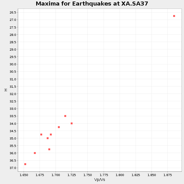
Plot maxima for each earthquake.
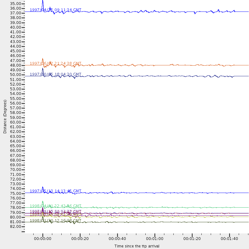
Events Used in the Stack
(10 events)| Radial Match | Distance | Baz | FERegion | Time | Lat/Lon | Depth | Magnitude |
| 98.79385 | 81.6 deg | 157.931 deg | Balleny Islands Region | 1998/03/25 03:12:25 GMT | (-62.9, 149.5) | 10 km | 6.6 MB, 8.0 MS, 8.3 UNKNOWN, 8.1 MW |
| 98.52017 | 81.0 deg | 240.08 deg | Near Coast Of Central Chile | 1997/10/15 01:03:33 GMT | (-30.9, -71.2) | 58 km | 6.8 MB, 6.8 MS, 7.3 UNKNOWN, 7.1 MW |
| 97.57804 | 83.2 deg | 246.862 deg | Near Coast Of Northern Chile | 1998/01/30 12:16:08 GMT | (-23.9, -70.2) | 42 km | 6.3 MB, 6.5 MS, 7.0 UNKNOWN, 6.7 ME |
| 95.29564 | 81.1 deg | 239.963 deg | Near Coast Of Central Chile | 1998/01/12 10:14:07 GMT | (-31.0, -71.4) | 35 km | 5.8 MB, 6.2 MS, 6.6 UNKNOWN, 6.2 ME |
| 94.61675 | 79.8 deg | 230.2 deg | Off Coast Of Southern Chile | 1998/04/01 22:42:56 GMT | (-40.3, -74.9) | 9.0 km | 6.2 MB, 6.0 MS, 6.7 UNKNOWN, 6.6 ME |
| 92.619316 | 76.4 deg | 37.538 deg | Hindu Kush Region, Afghanistan | 1997/05/13 14:13:45 GMT | (36.4, 70.9) | 196 km | 6.1 MB, 6.5 UNKNOWN, 6.4 MW |
| 85.07359 | 34.5 deg | 220.838 deg | Southern Mid-Atlantic Ridge | 1997/04/25 09:11:34 GMT | (-48.3, -10.0) | 10 km | 5.8 MS, 5.3 MB, 5.8 UNKNOWN, 5.7 MW |
| 84.09031 | 49.4 deg | 212.137 deg | South Sandwich Islands Region | 1997/10/05 18:04:30 GMT | (-59.7, -29.2) | 274 km | 6.0 MB, 6.3 UNKNOWN, 6.3 MW |
| 81.74067 | 81.9 deg | 240.639 deg | Near Coast Of Central Chile | 1997/07/06 09:54:00 GMT | (-30.1, -71.9) | 19 km | 5.8 MB, 6.5 MS, 6.8 UNKNOWN, 6.4 ME |
| 80.36272 | 46.9 deg | 213.722 deg | South Sandwich Islands Region | 1997/06/02 21:24:38 GMT | (-57.8, -25.5) | 33 km | 5.9 MB, 5.8 MS, 6.1 UNKNOWN, 6.1 MW |
Losers
(15 events)| Radial Match | Distance | Baz | FERegion | Time | Lat/Lon | Depth | Magnitude | Reason |
| 80.00538 | 82.1 deg | 241.417 deg | Near Coast Of Central Chile | 1997/07/19 12:22:57 GMT | (-29.3, -71.7) | 26 km | 5.8 MB, 5.5 MS, 5.9 UNKNOWN, 5.8 MW | |
| 77.4365 | 76.3 deg | 37.45 deg | Hindu Kush Region, Afghanistan | 1997/12/17 05:51:29 GMT | (36.4, 70.8) | 207 km | 5.5 MB, 6.3 UNKNOWN | |
| 74.89313 | 41.6 deg | 81.419 deg | Mid-Indian Ridge | 1997/09/25 14:20:48 GMT | (-13.8, 66.2) | 10 km | 5.3 MB, 5.7 MS, 6.0 UNKNOWN, 6.0 MW | |
| 69.98208 | 86.3 deg | 256.617 deg | Peru-Bolivia Border Region | 1997/11/28 22:53:41 GMT | (-13.7, -68.8) | 586 km | 6.4 MB, 6.6 UNKNOWN, 6.6 MW | |
| 69.48141 | 80.6 deg | 158.004 deg | South Of Australia | 1998/03/25 12:17:22 GMT | (-63.6, 147.9) | 10 km | 5.8 MB, 6.1 MS, 6.5 UNKNOWN | |
| 68.108894 | 48.8 deg | 68.294 deg | Carlsberg Ridge | 1998/01/14 18:53:14 GMT | (-2.1, 68.1) | 10 km | 5.6 MS, 5.3 MB | |
| 66.86216 | 84.9 deg | 93.837 deg | Java Sea | 1997/07/11 09:55:12 GMT | (-5.7, 110.8) | 574 km | 5.6 MB | |
| 66.8519 | 80.3 deg | 249.224 deg | Jujuy Province, Argentina | 1997/07/20 10:14:22 GMT | (-23.0, -66.3) | 256 km | 5.7 MB, 6.1 UNKNOWN, 5.7 ME | |
| 66.83691 | 48.6 deg | 123.727 deg | Mid-Indian Ridge | 1997/08/20 13:51:16 GMT | (-41.7, 80.1) | 10 km | 5.6 MB, 6.4 MS, 6.5 UNKNOWN, 6.4 MW | |
| 65.938225 | 81.2 deg | 244.173 deg | Northern Chile | 1997/05/17 02:10:18 GMT | (-27.2, -69.5) | 106 km | 5.5 MB, 5.6 UNKNOWN, 5.5 MW | |
| 61.41368 | 45.1 deg | 296.484 deg | North Of Ascension Island | 1998/04/10 16:40:38 GMT | (-1.3, -15.7) | 10 km | 5.9 MS, 5.4 MB, 6.2 UNKNOWN, 6.1 MW | |
| 59.797173 | 82.3 deg | 248.921 deg | Northern Chile | 1997/09/28 23:13:13 GMT | (-22.4, -68.4) | 107 km | 5.7 MB, 5.6 UNKNOWN, 5.6 MW | |
| 57.934475 | 35.4 deg | 244.713 deg | Southern Mid-Atlantic Ridge | 1998/01/03 06:10:08 GMT | (-35.5, -16.2) | 10 km | 5.9 MS, 5.4 MB, 6.3 UNKNOWN, 6.1 MW | |
| 54.606384 | 43.7 deg | 80.334 deg | Mid-Indian Ridge | 1998/04/09 23:26:52 GMT | (-12.2, 67.8) | 10 km | 5.5 MB, 5.4 MS, 5.9 UNKNOWN, 5.9 MW | |
| 43.045437 | 83.2 deg | 250.93 deg | Chile-Bolivia Border Region | 1997/12/09 14:23:45 GMT | (-20.2, -68.4) | 133 km | 5.7 MB, 5.7 UNKNOWN, 5.7 MW |
