
Station XA SA42 - XA.SA42
Network: XA97 - Anatomy of an Archean Craton, South Africa
Nearby stations (2 deg radius)
| Station | Name | (Lat, Lon) | Start / End | Elevation |
| SA42 | XA.SA42 | (-25.67, 29.22) | 1998-05-27 / 1999-12-31 | 1500 m |
| Crust2 Type: | G1,Archean, no seds. |
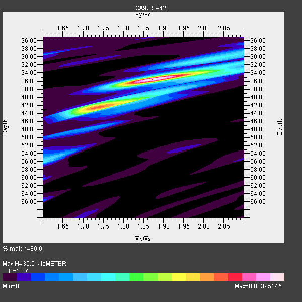
| Thickness Estimate: | 36 km |
| Thickness StdDev: | 8.2 km |
| Vp/Vs Estimate: | 1.87 |
| Vp/Vs StdDev: | 0.11 |
| Vs Estimate: | 3.454 km/s |
| Poisson's Ratio: | 0.30 |
| Peak Value: | 0.03 |
| Assumed Vp: | 6.459 km/s |
| Ps Weight: | 0.33333334 |
| PpPs Weight: | 0.33333334 |
| PsPs Weight: | 0.33333328 |
| Residual Complexity: | 0.532 |
| Nearby stations H: | +- |
| (2.0 deg) Vp/Vs: | +- |
1 with match > 90% ( 4.5454545 %) and 2 with match > 80% ( 9.090909 %) out of 22.
Download stack as xyz text file.
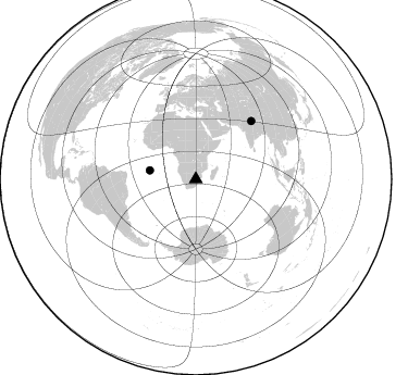
Azimuth Distribution of Events:
Prior Results for this Station
| Study | Thickness | Vp/Vs | Vp | Vs | Poissons Ratio | Extra |
| EARS | 36 km | 1.87 | 6.459 km/s | 3.454 km/s | 0.30 | |
| Crust2.0 | 37 km | 1.76 | 6.459 km/s | 3.665 km/s | 0.26 | G1,Archean, no seds. |
| Global Maxima | 36 km | 1.87 | 6.459 km/s | 3.454 km/s | 0.30 | amp=0.03395145 |
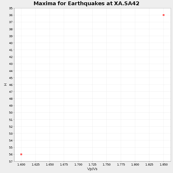
| Local Maxima 1 | 42 km | 1.73 | 6.459 km/s | 3.734 km/s | 0.25 | amp=0.019076504 |
| Local Maxima 2 | 56 km | 1.60 | 6.459 km/s | 4.037 km/s | 0.18 | amp=0.012449204 |
| Local Maxima 3 | 38 km | 1.91 | 6.459 km/s | 3.373 km/s | 0.31 | amp=0.009892742 |
| Local Maxima 4 | 35 km | 2.02 | 6.459 km/s | 3.198 km/s | 0.34 | amp=0.00792296 |
| Predicted Arrivals for vertical incidence (zero ray parameter) | |
| Ps | 4.78 SECOND |
| PpPs | 15.77 SECOND |
| PsPs/PpSs | 20.55 SECOND |
Events Processed for this Station
Download zip of receiver functions as SAC
Plot maxima for each earthquake.
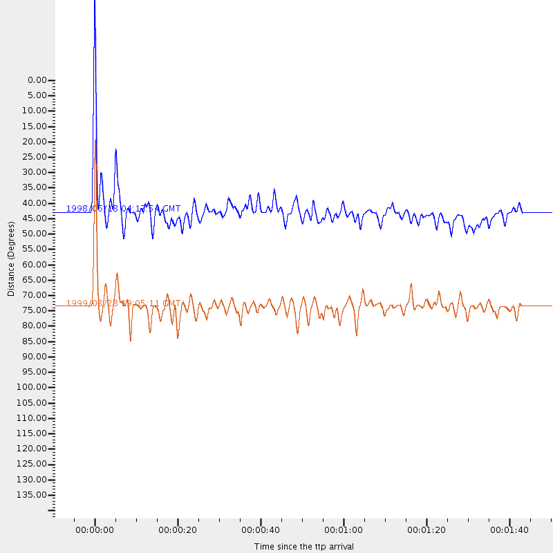
Events Used in the Stack
(2 events)| Radial Match | Distance | Baz | FERegion | Time | Lat/Lon | Depth | Magnitude |
| 94.22799 | 73.7 deg | 43.686 deg | Western Xizang-India Border Reg. | 1999/03/28 19:05:11 GMT | (30.5, 79.4) | 15 km | 6.4 MB, 6.6 MS, 6.6 MW, 6.5 ME |
| 81.90344 | 43.0 deg | 280.84 deg | Ascension Island Region | 1998/06/18 04:17:54 GMT | (-11.6, -13.9) | 10 km | 6.1 MS, 5.4 MB, 6.2 UNKNOWN |
Losers
(20 events)| Radial Match | Distance | Baz | FERegion | Time | Lat/Lon | Depth | Magnitude | Reason |
| 79.73103 | 86.5 deg | 239.089 deg | Near Coast Of Central Chile | 1998/09/03 17:37:58 GMT | (-29.5, -71.7) | 27 km | 6.2 MB, 6.6 MS, 6.5 UNKNOWN, 6.4 ME | |
| 78.34426 | 94.7 deg | 86.317 deg | Celebes Sea | 1999/03/04 08:52:01 GMT | (5.4, 121.9) | 33 km | 6.4 MB, 6.5 MS, 7.1 MW, 7.1 MW | |
| 74.605736 | 84.8 deg | 236.714 deg | Near Coast Of Central Chile | 1998/07/29 07:14:24 GMT | (-32.3, -71.3) | 51 km | 6.3 MB, 6.5 UNKNOWN, 6.5 ME | |
| 70.03757 | 95.8 deg | 100.501 deg | Banda Sea | 1998/11/09 05:30:14 GMT | (-7.0, 129.0) | 33 km | 6.1 MB, 6.7 UNKNOWN, 6.6 ME | |
| 68.674965 | 41.0 deg | 241.971 deg | Southern Mid-Atlantic Ridge | 1998/06/24 10:44:30 GMT | (-37.3, -17.4) | 10 km | 5.7 MB, 5.8 MS, 6.0 UNKNOWN, 5.9 MW | |
| 68.21769 | 73.3 deg | 34.091 deg | Afghanistan-Tajikistan Bord Reg. | 1998/12/11 20:16:24 GMT | (36.5, 71.0) | 223 km | 5.7 UNKNOWN, 5.0 MB, 5.6 MW | |
| 67.24672 | 73.3 deg | 33.11 deg | Afghanistan-Tajikistan Bord Reg. | 1998/05/30 06:22:28 GMT | (37.1, 70.1) | 33 km | 5.9 MB, 6.9 MS, 6.6 UNKNOWN, 6.5 MW | |
| 67.13831 | 79.2 deg | 49.085 deg | Xizang | 1998/07/20 01:05:58 GMT | (30.1, 88.2) | 33 km | 5.7 UNKNOWN, 5.4 MS, 5.4 MB | |
| 66.01436 | 50.3 deg | 217.681 deg | South Sandwich Islands Region | 1998/08/29 08:30:21 GMT | (-55.7, -27.0) | 33 km | 5.6 MB, 5.6 MS, 6.0 UNKNOWN, 5.9 MW | |
| 58.940495 | 82.9 deg | 155.435 deg | West Of Macquarie Island | 1998/06/29 23:37:16 GMT | (-60.4, 153.1) | 10 km | 5.8 MS, 5.0 MB, 6.3 UNKNOWN, 6.0 MW | |
| 58.40029 | 93.0 deg | 91.164 deg | Minahassa Peninsula, Sulawesi | 1998/09/21 06:52:41 GMT | (0.3, 122.5) | 147 km | 6.1 MB, 6.0 UNKNOWN, 5.9 MW | |
| 56.991817 | 96.8 deg | 91.997 deg | Northern Molucca Sea | 1998/12/16 17:45:05 GMT | (1.1, 126.2) | 33 km | 5.9 MB, 5.8 MS, 6.2 UNKNOWN, 6.0 MW | |
| 56.329437 | 86.9 deg | 246.387 deg | Northern Chile | 1999/03/02 17:45:55 GMT | (-22.7, -68.5) | 111 km | 5.8 MB, 6.1 MW, 5.9 MW | |
| 54.270905 | 71.2 deg | 71.885 deg | Nicobar Islands, India Region | 1998/08/10 09:52:14 GMT | (7.3, 94.3) | 33 km | 5.9 MB, 5.8 MS, 6.0 UNKNOWN | |
| 51.80855 | 83.4 deg | 237.613 deg | Mendoza Province, Argentina | 1998/11/27 10:27:02 GMT | (-32.1, -69.3) | 127 km | 5.2 MB, 5.5 UNKNOWN, 5.3 MD | |
| 47.07003 | 88.4 deg | 297.989 deg | Northern Mid-Atlantic Ridge | 1999/04/06 04:51:05 GMT | (24.5, -46.4) | 10 km | 5.6 MS, 5.3 MB, 5.9 MW, 5.8 MW | |
| 39.947544 | 93.2 deg | 249.959 deg | Near Coast Of Peru | 1999/04/03 06:17:18 GMT | (-16.7, -72.7) | 87 km | 6.1 MB, 6.2 MS, 6.8 MW, 6.8 MW | |
| 38.68681 | 82.0 deg | 231.509 deg | S. Chile-Argentina Border Region | 1998/12/14 16:25:24 GMT | (-38.2, -71.0) | 138 km | 6.0 UNKNOWN, 4.8 MS, 5.4 MB | |
| 37.47693 | 49.6 deg | 216.264 deg | South Sandwich Islands Region | 1998/10/03 06:48:12 GMT | (-56.6, -25.4) | 33 km | 5.5 MS, 4.9 MB | |
| 33.86895 | 95.2 deg | 92.642 deg | Southern Molucca Sea | 1998/08/28 12:40:58 GMT | (-0.2, 125.0) | 66 km | 6.2 MB, 6.1 UNKNOWN, 6.1 MW |
