
Station XA SA43 - XA.SA43
Network: XA97 - Anatomy of an Archean Craton, South Africa
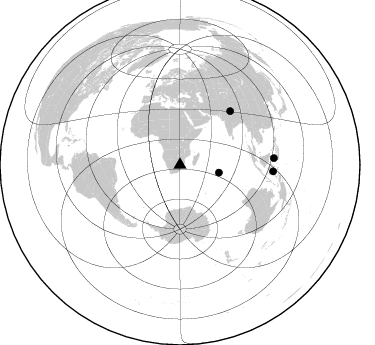
Nearby stations (2 deg radius)
| Station | Name | (Lat, Lon) | Start / End | Elevation |
| SA43 | XA.SA43 | (-25.79, 30.07) | 1998-11-26 / 1999-12-31 | 1800 m |
| Crust2 Type: | IE,late Proter., no seds. |
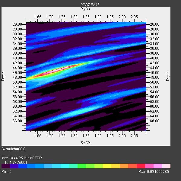
| Thickness Estimate: | 44 km |
| Thickness StdDev: | 6.1 km |
| Vp/Vs Estimate: | 1.75 |
| Vp/Vs StdDev: | 0.11 |
| Vs Estimate: | 3.805 km/s |
| Poisson's Ratio: | 0.26 |
| Peak Value: | 0.02 |
| Assumed Vp: | 6.65 km/s |
| Ps Weight: | 0.33333334 |
| PpPs Weight: | 0.33333334 |
| PsPs Weight: | 0.33333328 |
| Residual Complexity: | 0.646 |
| Nearby stations H: | +- |
| (2.0 deg) Vp/Vs: | +- |
3 with match > 90% ( 23.076923 %) and 4 with match > 80% ( 30.76923 %) out of 13.
Download stack as xyz text file.
Azimuth Distribution of Events:
Prior Results for this Station
| Study | Thickness | Vp/Vs | Vp | Vs | Poissons Ratio | Extra |
| EARS | 44 km | 1.75 | 6.65 km/s | 3.805 km/s | 0.26 | |
| Crust2.0 | 36 km | 1.77 | 6.65 km/s | 3.758 km/s | 0.27 | IE,late Proter., no seds. |
| Global Maxima | 44 km | 1.75 | 6.65 km/s | 3.805 km/s | 0.26 | amp=0.024509285 |
| Local Maxima 1 | 48 km | 1.65 | 6.65 km/s | 4.036 km/s | 0.21 | amp=0.0137939295 |
| Local Maxima 2 | 62 km | 1.84 | 6.65 km/s | 3.614 km/s | 0.29 | amp=0.011000671 |
| Local Maxima 3 | 34 km | 2.05 | 6.65 km/s | 3.248 km/s | 0.34 | amp=0.0063567893 |
| Local Maxima 4 | 65 km | 1.72 | 6.65 km/s | 3.872 km/s | 0.24 | amp=0.006295965 |
| Predicted Arrivals for vertical incidence (zero ray parameter) | |
| Ps | 4.97 SECOND |
| PpPs | 18.28 SECOND |
| PsPs/PpSs | 23.26 SECOND |
Events Processed for this Station
Download zip of receiver functions as SAC
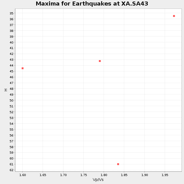
Plot maxima for each earthquake.
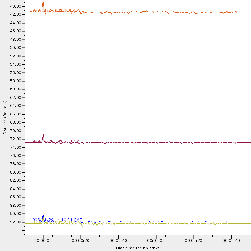
Events Used in the Stack
(4 events)| Radial Match | Distance | Baz | FERegion | Time | Lat/Lon | Depth | Magnitude |
| 97.63418 | 93.5 deg | 93.948 deg | Ceram Sea | 1998/11/29 14:10:31 GMT | (-2.1, 124.9) | 33 km | 6.5 MB, 7.7 MS, 8.1 UNKNOWN, 7.8 MW |
| 97.49951 | 73.2 deg | 43.132 deg | Western Xizang-India Border Reg. | 1999/03/28 19:05:11 GMT | (30.5, 79.4) | 15 km | 6.4 MB, 6.6 MS, 6.6 MW, 6.5 ME |
| 90.32831 | 94.0 deg | 85.966 deg | Celebes Sea | 1999/03/04 08:52:01 GMT | (5.4, 121.9) | 33 km | 6.4 MB, 6.5 MS, 7.1 MW, 7.1 MW |
| 87.0867 | 39.7 deg | 101.053 deg | Mid-Indian Ridge | 1999/01/24 08:00:08 GMT | (-26.5, 74.5) | 10 km | 6.0 MB, 6.3 MS, 6.3 MW, 6.3 ME |
Losers
(9 events)| Radial Match | Distance | Baz | FERegion | Time | Lat/Lon | Depth | Magnitude | Reason |
| 72.747665 | 89.6 deg | 89.593 deg | Minahassa Peninsula, Sulawesi | 1999/02/23 07:27:56 GMT | (0.2, 119.5) | 33 km | 5.6 MB, 5.8 MS | |
| 71.5606 | 83.1 deg | 234.928 deg | Chile-Argentina Border Region | 1999/03/05 03:35:14 GMT | (-34.7, -69.6) | 10 km | 5.5 MS, 5.2 MB | |
| 64.76037 | 69.7 deg | 74.927 deg | Northern Sumatra, Indonesia | 1999/02/04 19:28:00 GMT | (4.0, 95.3) | 56 km | 5.8 MB, 5.4 MS, 5.9 MW, 5.9 MW | |
| 63.26183 | 70.4 deg | 33.837 deg | Southeastern Afghanistan | 1999/02/11 14:08:51 GMT | (34.3, 69.4) | 33 km | 5.8 MS, 5.4 MB, 6.0 MW, 6.0 MW | |
| 63.173714 | 93.8 deg | 91.87 deg | Southern Molucca Sea | 1999/03/18 01:59:00 GMT | (-0.0, 124.3) | 88 km | 5.5 MB, 5.1 MS, 5.8 MW, 5.8 MW | |
| 58.43735 | 70.3 deg | 12.961 deg | Eastern Caucasus | 1999/01/31 05:07:13 GMT | (43.2, 46.8) | 33 km | 5.8 MW, 5.4 MS, 5.3 MB, 5.7 MW | |
| 53.47024 | 94.1 deg | 86.193 deg | Celebes Sea | 1999/03/05 13:01:10 GMT | (5.3, 122.2) | 33 km | 5.6 MB, 5.1 MS, 5.7 MW, 5.7 MW | |
| 51.449005 | 84.0 deg | 237.305 deg | Mendoza Province, Argentina | 1998/11/27 10:27:02 GMT | (-32.1, -69.3) | 127 km | 5.2 MB, 5.5 UNKNOWN, 5.3 MD | |
| 46.976192 | 58.9 deg | 78.457 deg | South Indian Ocean | 1999/03/29 06:17:58 GMT | (-4.0, 87.3) | 10 km | 5.5 MS, 5.4 MB, 5.8 MW, 5.8 MW |
