
Station XA SA50 - XA.SA50
Network: XA97 - Anatomy of an Archean Craton, South Africa
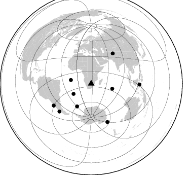
Nearby stations (2 deg radius)
| Station | Name | (Lat, Lon) | Start / End | Elevation |
| SA50 | XA.SA50 | (-23.87, 27.17) | 1997-04-25 / 1999-12-31 | 976 m |
| Crust2 Type: | G1,Archean, no seds. |
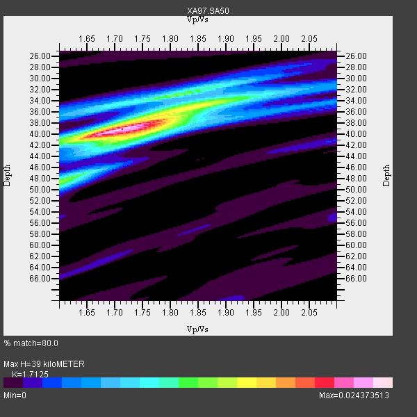
| Thickness Estimate: | 39 km |
| Thickness StdDev: | 1.6 km |
| Vp/Vs Estimate: | 1.71 |
| Vp/Vs StdDev: | 0.04 |
| Vs Estimate: | 3.772 km/s |
| Poisson's Ratio: | 0.24 |
| Peak Value: | 0.02 |
| Assumed Vp: | 6.459 km/s |
| Ps Weight: | 0.33333334 |
| PpPs Weight: | 0.33333334 |
| PsPs Weight: | 0.33333328 |
| Residual Complexity: | 0.597 |
| Nearby stations H: | +- |
| (2.0 deg) Vp/Vs: | +- |
4 with match > 90% ( 17.391304 %) and 9 with match > 80% ( 39.130436 %) out of 23.
Download stack as xyz text file.
Azimuth Distribution of Events:
Prior Results for this Station
| Study | Thickness | Vp/Vs | Vp | Vs | Poissons Ratio | Extra |
| EARS | 39 km | 1.71 | 6.459 km/s | 3.772 km/s | 0.24 | |
| Crust2.0 | 37 km | 1.76 | 6.459 km/s | 3.665 km/s | 0.26 | G1,Archean, no seds. |
| Global Maxima | 39 km | 1.71 | 6.459 km/s | 3.772 km/s | 0.24 | amp=0.024373513 |
| Local Maxima 1 | 35 km | 1.85 | 6.459 km/s | 3.501 km/s | 0.29 | amp=0.014214498 |
| Local Maxima 2 | 48 km | 1.60 | 6.459 km/s | 4.031 km/s | 0.18 | amp=0.012258146 |
| Local Maxima 3 | 32 km | 1.84 | 6.459 km/s | 3.515 km/s | 0.29 | amp=0.008366362 |
| Local Maxima 4 | 40 km | 1.75 | 6.459 km/s | 3.691 km/s | 0.26 | amp=0.007910514 |
| Predicted Arrivals for vertical incidence (zero ray parameter) | |
| Ps | 4.30 SECOND |
| PpPs | 16.38 SECOND |
| PsPs/PpSs | 20.68 SECOND |
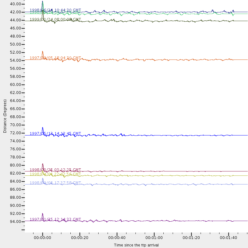
Events Processed for this Station
Download zip of receiver functions as SAC
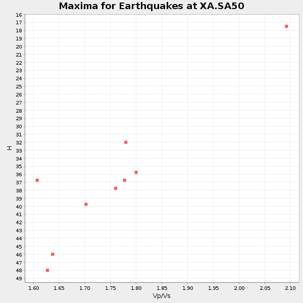
Plot maxima for each earthquake.
Events Used in the Stack
(9 events)| Radial Match | Distance | Baz | FERegion | Time | Lat/Lon | Depth | Magnitude |
| 99.00622 | 82.4 deg | 157.007 deg | Balleny Islands Region | 1998/03/25 03:12:25 GMT | (-62.9, 149.5) | 10 km | 6.6 MB, 8.0 MS, 8.3 UNKNOWN, 8.1 MW |
| 94.37869 | 83.5 deg | 228.821 deg | Off Coast Of Southern Chile | 1998/04/01 22:42:56 GMT | (-40.3, -74.9) | 9.0 km | 6.2 MB, 6.0 MS, 6.7 UNKNOWN, 6.6 ME |
| 92.61855 | 72.8 deg | 35.745 deg | Hindu Kush Region, Afghanistan | 1997/05/13 14:13:45 GMT | (36.4, 70.9) | 196 km | 6.1 MB, 6.5 UNKNOWN, 6.4 MW |
| 92.185234 | 40.3 deg | 239.953 deg | Southern Mid-Atlantic Ridge | 1998/06/24 10:44:30 GMT | (-37.3, -17.4) | 10 km | 5.7 MB, 5.8 MS, 6.0 UNKNOWN, 5.9 MW |
| 89.61478 | 42.7 deg | 103.744 deg | Mid-Indian Ridge | 1999/01/24 08:00:08 GMT | (-26.5, 74.5) | 10 km | 6.0 MB, 6.3 MS, 6.3 MW, 6.3 ME |
| 88.90573 | 85.8 deg | 239.778 deg | Near Coast Of Central Chile | 1998/09/03 17:37:58 GMT | (-29.5, -71.7) | 27 km | 6.2 MB, 6.6 MS, 6.5 UNKNOWN, 6.4 ME |
| 88.42675 | 40.8 deg | 280.12 deg | Ascension Island Region | 1998/06/18 04:17:54 GMT | (-11.6, -13.9) | 10 km | 6.1 MS, 5.4 MB, 6.2 UNKNOWN |
| 87.963234 | 95.4 deg | 91.034 deg | Minahassa Peninsula, Sulawesi | 1997/11/25 12:14:33 GMT | (1.2, 122.5) | 24 km | 6.1 MB, 6.8 MS, 7.1 UNKNOWN, 6.7 ME |
| 84.87441 | 52.9 deg | 211.937 deg | South Sandwich Islands Region | 1997/10/05 18:04:30 GMT | (-59.7, -29.2) | 274 km | 6.0 MB, 6.3 UNKNOWN, 6.3 MW |
Losers
(14 events)| Radial Match | Distance | Baz | FERegion | Time | Lat/Lon | Depth | Magnitude | Reason |
| 79.132515 | 79.9 deg | 319.826 deg | Azores Islands, Portugal | 1997/06/27 04:39:52 GMT | (38.3, -26.7) | 10 km | 5.6 MB, 5.4 MS, 5.9 UNKNOWN, 5.9 MW | |
| 77.16792 | 85.6 deg | 239.169 deg | Near Coast Of Central Chile | 1997/07/06 09:54:00 GMT | (-30.1, -71.9) | 19 km | 5.8 MB, 6.5 MS, 6.8 UNKNOWN, 6.4 ME | |
| 69.07132 | 79.5 deg | 56.887 deg | India-Bangladesh Border Region | 1997/05/08 02:53:14 GMT | (24.9, 92.2) | 35 km | 5.6 MB, 5.6 MS, 6.0 UNKNOWN, 5.9 MW | |
| 68.04861 | 38.2 deg | 81.903 deg | Mid-Indian Ridge | 1997/09/25 14:20:48 GMT | (-13.8, 66.2) | 10 km | 5.3 MB, 5.7 MS, 6.0 UNKNOWN, 6.0 MW | |
| 66.6649 | 49.6 deg | 291.589 deg | North Of Ascension Island | 1998/03/29 07:14:58 GMT | (-0.2, -17.9) | 10 km | 5.5 MB, 5.6 MS, 6.1 UNKNOWN, 6.1 MW | |
| 65.45384 | 40.2 deg | 80.606 deg | Mid-Indian Ridge | 1998/04/09 23:26:52 GMT | (-12.2, 67.8) | 10 km | 5.5 MB, 5.4 MS, 5.9 UNKNOWN, 5.9 MW | |
| 64.35905 | 85.8 deg | 239.942 deg | Near Coast Of Central Chile | 1997/07/19 12:22:57 GMT | (-29.3, -71.7) | 26 km | 5.8 MB, 5.5 MS, 5.9 UNKNOWN, 5.8 MW | |
| 60.79907 | 86.0 deg | 247.398 deg | Northern Chile | 1997/09/28 23:13:13 GMT | (-22.4, -68.4) | 107 km | 5.7 MB, 5.6 UNKNOWN, 5.6 MW | |
| 59.908398 | 84.0 deg | 247.67 deg | Jujuy Province, Argentina | 1997/07/20 10:14:22 GMT | (-23.0, -66.3) | 256 km | 5.7 MB, 6.1 UNKNOWN, 5.7 ME | |
| 55.139065 | 47.1 deg | 291.971 deg | North Of Ascension Island | 1998/04/10 16:40:38 GMT | (-1.3, -15.7) | 10 km | 5.9 MS, 5.4 MB, 6.2 UNKNOWN, 6.1 MW | |
| 53.783237 | 50.6 deg | 216.418 deg | South Sandwich Islands Region | 1998/08/29 08:30:21 GMT | (-55.7, -27.0) | 33 km | 5.6 MB, 5.6 MS, 6.0 UNKNOWN, 5.9 MW | |
| 50.011383 | 84.9 deg | 242.672 deg | Northern Chile | 1997/05/17 02:10:18 GMT | (-27.2, -69.5) | 106 km | 5.5 MB, 5.6 UNKNOWN, 5.5 MW | |
| 35.0652 | 61.1 deg | 354.276 deg | Ionian Sea | 1997/11/18 13:13:46 GMT | (37.3, 20.9) | 33 km | 5.5 ML, 5.4 MB | |
| 18.96698 | 81.9 deg | 92.654 deg | Java Sea | 1997/07/11 09:55:12 GMT | (-5.7, 110.8) | 574 km | 5.6 MB |
