
Station XA SA53 - XA.SA53
Network: XA97 - Anatomy of an Archean Craton, South Africa
Nearby stations (2 deg radius)
| Station | Name | (Lat, Lon) | Start / End | Elevation |
| SA53 | XA.SA53 | (-24.11, 29.33) | 1998-05-28 / 1999-12-31 | 1300 m |
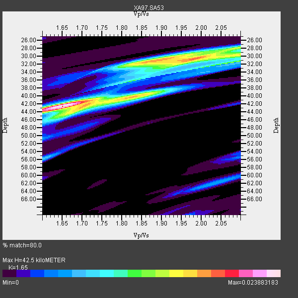
| Crust2 Type: | G1,Archean, no seds. |
| Thickness Estimate: | 42 km |
| Thickness StdDev: | 4.9 km |
| Vp/Vs Estimate: | 1.65 |
| Vp/Vs StdDev: | 0.16 |
| Vs Estimate: | 3.915 km/s |
| Poisson's Ratio: | 0.21 |
| Peak Value: | 0.02 |
| Assumed Vp: | 6.459 km/s |
| Ps Weight: | 0.33333334 |
| PpPs Weight: | 0.33333334 |
| PsPs Weight: | 0.33333328 |
| Residual Complexity: | 0.773 |
| Nearby stations H: | +- |
| (2.0 deg) Vp/Vs: | +- |
0 with match > 90% ( 0.0 %) and 3 with match > 80% ( 21.428572 %) out of 14.
Download stack as xyz text file.
Azimuth Distribution of Events:

Prior Results for this Station
| Study | Thickness | Vp/Vs | Vp | Vs | Poissons Ratio | Extra |
| EARS | 42 km | 1.65 | 6.459 km/s | 3.915 km/s | 0.21 | |
| Crust2.0 | 37 km | 1.76 | 6.459 km/s | 3.665 km/s | 0.26 | G1,Archean, no seds. |
| Global Maxima | 42 km | 1.65 | 6.459 km/s | 3.915 km/s | 0.21 | amp=0.023883183 |
| Local Maxima 1 | 30 km | 1.99 | 6.459 km/s | 3.254 km/s | 0.33 | amp=0.01828827 |
| Local Maxima 2 | 44 km | 1.69 | 6.459 km/s | 3.834 km/s | 0.23 | amp=0.012031247 |
| Local Maxima 3 | 31 km | 2.10 | 6.459 km/s | 3.083 km/s | 0.35 | amp=0.01194196 |
| Local Maxima 4 | 31 km | 1.89 | 6.459 km/s | 3.418 km/s | 0.31 | amp=0.011418133 |
| Predicted Arrivals for vertical incidence (zero ray parameter) | |
| Ps | 4.28 SECOND |
| PpPs | 17.44 SECOND |
| PsPs/PpSs | 21.71 SECOND |
Events Processed for this Station
Download zip of receiver functions as SAC
Plot maxima for each earthquake.
Events Used in the Stack
(3 events)| Radial Match | Distance | Baz | FERegion | Time | Lat/Lon | Depth | Magnitude |
| 82.415634 | 85.8 deg | 236.566 deg | Near Coast Of Central Chile | 1998/07/29 07:14:24 GMT | (-32.3, -71.3) | 51 km | 6.3 MB, 6.5 UNKNOWN, 6.5 ME |
| 81.3073 | 42.8 deg | 279.138 deg | Ascension Island Region | 1998/06/18 04:17:54 GMT | (-11.6, -13.9) | 10 km | 6.1 MS, 5.4 MB, 6.2 UNKNOWN |
| 80.10497 | 41.9 deg | 240.447 deg | Southern Mid-Atlantic Ridge | 1998/06/24 10:44:30 GMT | (-37.3, -17.4) | 10 km | 5.7 MB, 5.8 MS, 6.0 UNKNOWN, 5.9 MW |
Losers
(11 events)| Radial Match | Distance | Baz | FERegion | Time | Lat/Lon | Depth | Magnitude | Reason |
| 79.471695 | 40.7 deg | 103.122 deg | Mid-Indian Ridge | 1999/01/24 08:00:08 GMT | (-26.5, 74.5) | 10 km | 6.0 MB, 6.3 MS, 6.3 MW, 6.3 ME | |
| 72.696625 | 83.1 deg | 231.313 deg | S. Chile-Argentina Border Region | 1998/12/14 16:25:24 GMT | (-38.2, -71.0) | 138 km | 6.0 UNKNOWN, 4.8 MS, 5.4 MB | |
| 69.30212 | 96.8 deg | 91.656 deg | Northern Molucca Sea | 1998/12/06 00:47:13 GMT | (1.3, 126.2) | 33 km | 6.3 MB, 6.2 MS, 6.6 UNKNOWN, 6.5 ME | |
| 67.06426 | 88.2 deg | 99.138 deg | Savu Sea | 1998/11/08 07:25:48 GMT | (-9.1, 121.4) | 33 km | 6.0 MB, 5.9 MS, 6.4 UNKNOWN, 5.7 ME | |
| 63.910496 | 69.9 deg | 75.889 deg | Northern Sumatra, Indonesia | 1999/02/04 19:28:00 GMT | (4.0, 95.3) | 56 km | 5.8 MB, 5.4 MS, 5.9 MW, 5.9 MW | |
| 62.695045 | 84.3 deg | 155.472 deg | West Of Macquarie Island | 1998/06/29 23:37:16 GMT | (-60.4, 153.1) | 10 km | 5.8 MS, 5.0 MB, 6.3 UNKNOWN, 6.0 MW | |
| 62.005177 | 78.1 deg | 49.26 deg | Xizang | 1998/07/20 01:05:58 GMT | (30.1, 88.2) | 33 km | 5.7 UNKNOWN, 5.4 MS, 5.4 MB | |
| 61.82599 | 70.6 deg | 72.337 deg | Nicobar Islands, India Region | 1998/08/10 09:52:14 GMT | (7.3, 94.3) | 33 km | 5.9 MB, 5.8 MS, 6.0 UNKNOWN | |
| 56.2296 | 89.0 deg | 248.185 deg | Chile-Bolivia Border Region | 1999/03/05 00:33:46 GMT | (-20.4, -68.9) | 111 km | 5.7 MB, 5.9 MW, 5.8 MW | |
| 55.361633 | 72.0 deg | 34.29 deg | Afghanistan-Tajikistan Bord Reg. | 1998/12/11 20:16:24 GMT | (36.5, 71.0) | 223 km | 5.7 UNKNOWN, 5.0 MB, 5.6 MW | |
| 37.521317 | 73.7 deg | 89.557 deg | Sunda Strait, Indonesia | 1999/02/03 06:35:56 GMT | (-6.2, 104.2) | 33 km | 5.6 MB, 5.6 MS, 5.8 MW, 5.7 MW |
