
Station XA SA54 - XA.SA54
Network: XA97 - Anatomy of an Archean Craton, South Africa
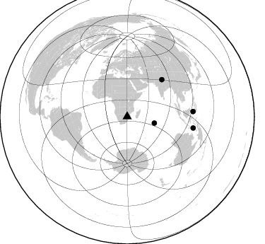
Nearby stations (2 deg radius)
| Station | Name | (Lat, Lon) | Start / End | Elevation |
| SA54 | XA.SA54 | (-23.73, 30.67) | 1998-06-26 / 1999-12-31 | 500 m |
| Crust2 Type: | I1,late Proter., no seds. |
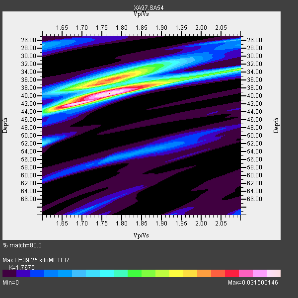
| Thickness Estimate: | 39 km |
| Thickness StdDev: | 4.0 km |
| Vp/Vs Estimate: | 1.77 |
| Vp/Vs StdDev: | 0.04 |
| Vs Estimate: | 3.758 km/s |
| Poisson's Ratio: | 0.26 |
| Peak Value: | 0.03 |
| Assumed Vp: | 6.642 km/s |
| Ps Weight: | 0.33333334 |
| PpPs Weight: | 0.33333334 |
| PsPs Weight: | 0.33333328 |
| Residual Complexity: | 0.656 |
| Nearby stations H: | +- |
| (2.0 deg) Vp/Vs: | +- |
2 with match > 90% ( 20.0 %) and 4 with match > 80% ( 40.0 %) out of 10.
Download stack as xyz text file.
Azimuth Distribution of Events:
Prior Results for this Station
| Study | Thickness | Vp/Vs | Vp | Vs | Poissons Ratio | Extra |
| EARS | 39 km | 1.77 | 6.642 km/s | 3.758 km/s | 0.26 | |
| Crust2.0 | 43 km | 1.77 | 6.642 km/s | 3.756 km/s | 0.26 | I1,late Proter., no seds. |
| Global Maxima | 39 km | 1.77 | 6.642 km/s | 3.758 km/s | 0.26 | amp=0.031500146 |
| Local Maxima 1 | 42 km | 1.67 | 6.642 km/s | 3.971 km/s | 0.22 | amp=0.02345608 |
| Local Maxima 2 | 36 km | 1.77 | 6.642 km/s | 3.742 km/s | 0.27 | amp=0.020810014 |
| Local Maxima 3 | 33 km | 2.10 | 6.642 km/s | 3.17 km/s | 0.35 | amp=0.0152542675 |
| Local Maxima 4 | 32 km | 1.88 | 6.642 km/s | 3.538 km/s | 0.30 | amp=0.011780429 |
| Predicted Arrivals for vertical incidence (zero ray parameter) | |
| Ps | 4.54 SECOND |
| PpPs | 16.35 SECOND |
| PsPs/PpSs | 20.89 SECOND |
Events Processed for this Station
Download zip of receiver functions as SAC
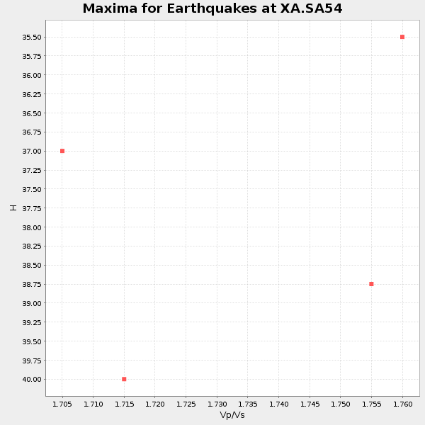
Plot maxima for each earthquake.
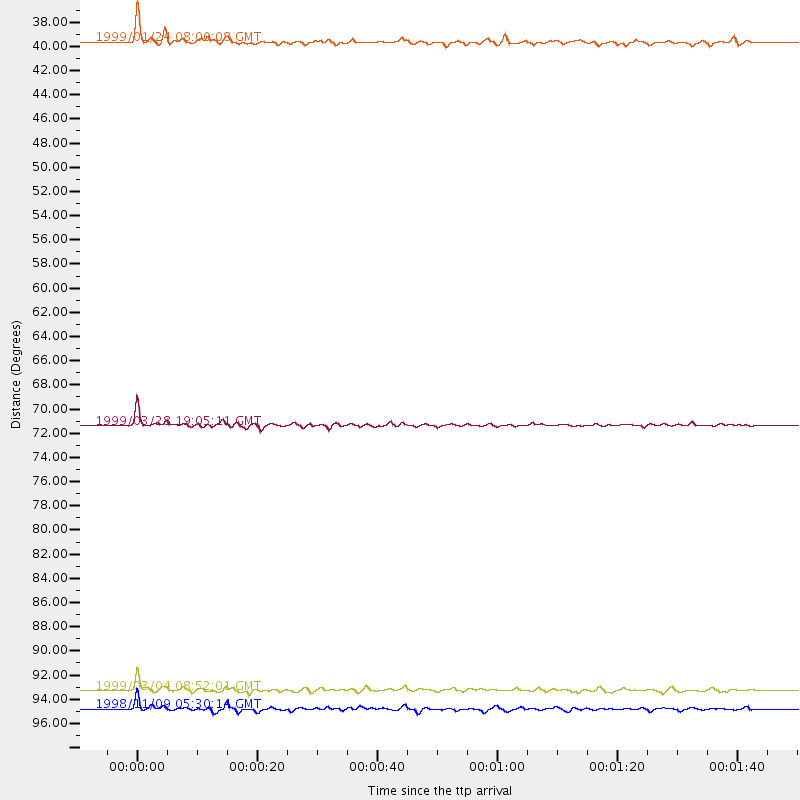
Events Used in the Stack
(4 events)| Radial Match | Distance | Baz | FERegion | Time | Lat/Lon | Depth | Magnitude |
| 94.900375 | 71.4 deg | 43.202 deg | Western Xizang-India Border Reg. | 1999/03/28 19:05:11 GMT | (30.5, 79.4) | 15 km | 6.4 MB, 6.6 MS, 6.6 MW, 6.5 ME |
| 90.37438 | 93.3 deg | 85.588 deg | Celebes Sea | 1999/03/04 08:52:01 GMT | (5.4, 121.9) | 33 km | 6.4 MB, 6.5 MS, 7.1 MW, 7.1 MW |
| 85.79473 | 39.6 deg | 103.357 deg | Mid-Indian Ridge | 1999/01/24 08:00:08 GMT | (-26.5, 74.5) | 10 km | 6.0 MB, 6.3 MS, 6.3 MW, 6.3 ME |
| 80.65872 | 94.8 deg | 99.703 deg | Banda Sea | 1998/11/09 05:30:14 GMT | (-7.0, 129.0) | 33 km | 6.1 MB, 6.7 UNKNOWN, 6.6 ME |
Losers
(6 events)| Radial Match | Distance | Baz | FERegion | Time | Lat/Lon | Depth | Magnitude | Reason |
| 72.82978 | 88.9 deg | 245.741 deg | Northern Chile | 1999/03/02 17:45:55 GMT | (-22.7, -68.5) | 111 km | 5.8 MB, 6.1 MW, 5.9 MW | |
| 69.39543 | 84.3 deg | 230.827 deg | S. Chile-Argentina Border Region | 1998/12/14 16:25:24 GMT | (-38.2, -71.0) | 138 km | 6.0 UNKNOWN, 4.8 MS, 5.4 MB | |
| 67.941765 | 57.7 deg | 27.743 deg | Southern Iran | 1999/03/04 05:38:26 GMT | (28.3, 57.2) | 33 km | 6.2 MB, 6.5 MS, 6.6 MW, 6.4 MW | |
| 61.922905 | 83.9 deg | 94.996 deg | Bali Sea | 1999/03/24 20:32:59 GMT | (-7.0, 117.1) | 621 km | 5.9 MW, 5.3 MB | |
| 49.07978 | 93.3 deg | 91.491 deg | Southern Molucca Sea | 1999/03/18 01:59:00 GMT | (-0.0, 124.3) | 88 km | 5.5 MB, 5.1 MS, 5.8 MW, 5.8 MW | |
| 47.043396 | 85.6 deg | 236.925 deg | Mendoza Province, Argentina | 1998/11/27 10:27:02 GMT | (-32.1, -69.3) | 127 km | 5.2 MB, 5.5 UNKNOWN, 5.3 MD |
