
Station XA SA55 - XA.SA55
Network: XA97 - Anatomy of an Archean Craton, South Africa
Nearby stations (2 deg radius)
| Station | Name | (Lat, Lon) | Start / End | Elevation |
| SA55 | XA.SA55 | (-22.98, 28.30) | 1997-04-26 / 1999-12-31 | 918 m |
| Crust2 Type: | G1,Archean, no seds. |
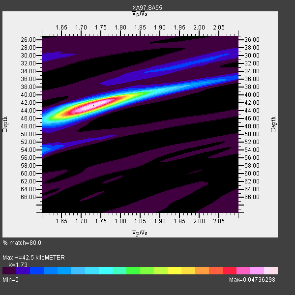
| Thickness Estimate: | 42 km |
| Thickness StdDev: | 1.0 km |
| Vp/Vs Estimate: | 1.73 |
| Vp/Vs StdDev: | 0.02 |
| Vs Estimate: | 3.734 km/s |
| Poisson's Ratio: | 0.25 |
| Peak Value: | 0.05 |
| Assumed Vp: | 6.459 km/s |
| Ps Weight: | 0.33333334 |
| PpPs Weight: | 0.33333334 |
| PsPs Weight: | 0.33333328 |
| Residual Complexity: | 0.413 |
| Nearby stations H: | +- |
| (2.0 deg) Vp/Vs: | +- |
5 with match > 90% ( 23.809525 %) and 8 with match > 80% ( 38.095238 %) out of 21.
Download stack as xyz text file.
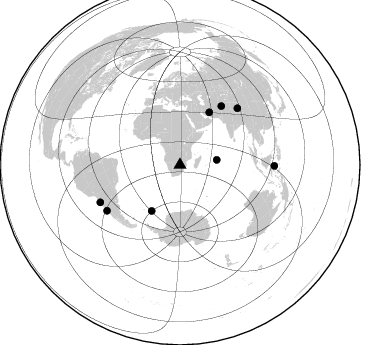
Azimuth Distribution of Events:
Prior Results for this Station
| Study | Thickness | Vp/Vs | Vp | Vs | Poissons Ratio | Extra |
| EARS | 42 km | 1.73 | 6.459 km/s | 3.734 km/s | 0.25 | |
| Crust2.0 | 37 km | 1.76 | 6.459 km/s | 3.665 km/s | 0.26 | G1,Archean, no seds. |
| Global Maxima | 42 km | 1.73 | 6.459 km/s | 3.734 km/s | 0.25 | amp=0.04736298 |
| Local Maxima 1 | 45 km | 1.68 | 6.459 km/s | 3.845 km/s | 0.23 | amp=0.024592359 |
| Local Maxima 2 | 40 km | 1.78 | 6.459 km/s | 3.624 km/s | 0.27 | amp=0.021663291 |
| Local Maxima 3 | 54 km | 1.60 | 6.459 km/s | 4.037 km/s | 0.18 | amp=0.007391723 |
| Local Maxima 4 | 38 km | 1.97 | 6.459 km/s | 3.283 km/s | 0.33 | amp=0.005379788 |
| Predicted Arrivals for vertical incidence (zero ray parameter) | |
| Ps | 4.80 SECOND |
| PpPs | 17.96 SECOND |
| PsPs/PpSs | 22.77 SECOND |
Events Processed for this Station
Download zip of receiver functions as SAC
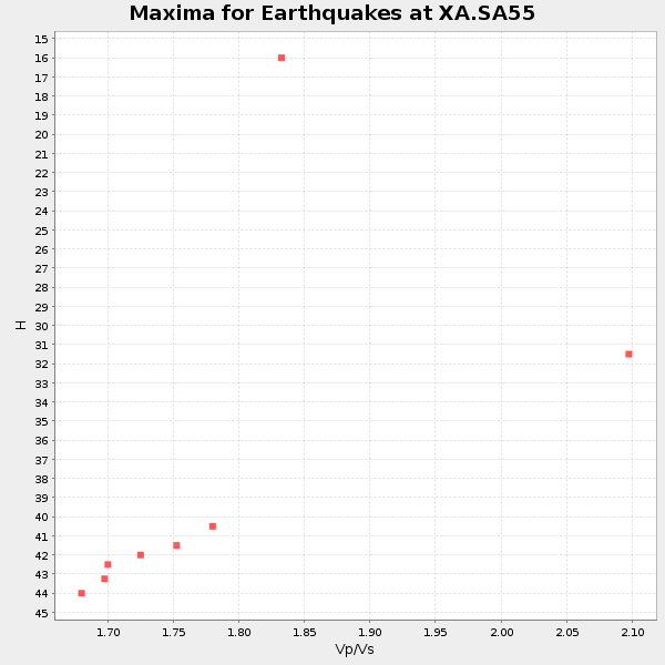
Plot maxima for each earthquake.
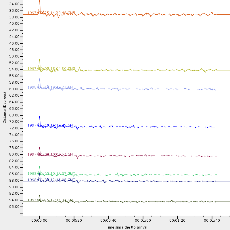
Events Used in the Stack
(8 events)| Radial Match | Distance | Baz | FERegion | Time | Lat/Lon | Depth | Magnitude |
| 95.42703 | 80.4 deg | 45.506 deg | Xizang | 1997/11/08 10:02:52 GMT | (35.1, 87.3) | 33 km | 6.2 MB, 7.9 MS, 7.7 UNKNOWN, 7.6 MW |
| 94.69636 | 86.3 deg | 238.032 deg | Near Coast Of Central Chile | 1998/01/12 10:14:07 GMT | (-31.0, -71.4) | 35 km | 5.8 MB, 6.2 MS, 6.6 UNKNOWN, 6.2 ME |
| 94.341736 | 88.2 deg | 244.898 deg | Near Coast Of Northern Chile | 1998/01/30 12:16:08 GMT | (-23.9, -70.2) | 42 km | 6.3 MB, 6.5 MS, 7.0 UNKNOWN, 6.7 ME |
| 93.313614 | 71.5 deg | 35.191 deg | Hindu Kush Region, Afghanistan | 1997/05/13 14:13:45 GMT | (36.4, 70.9) | 196 km | 6.1 MB, 6.5 UNKNOWN, 6.4 MW |
| 92.27011 | 59.9 deg | 29.355 deg | Northern And Central Iran | 1998/03/14 19:40:27 GMT | (30.2, 57.6) | 9.0 km | 5.9 MB, 6.9 MS, 6.6 UNKNOWN, 6.3 ME |
| 84.891335 | 54.2 deg | 211.796 deg | South Sandwich Islands Region | 1997/10/05 18:04:30 GMT | (-59.7, -29.2) | 274 km | 6.0 MB, 6.3 UNKNOWN, 6.3 MW |
| 83.1883 | 94.4 deg | 90.509 deg | Minahassa Peninsula, Sulawesi | 1997/11/25 12:14:33 GMT | (1.2, 122.5) | 24 km | 6.1 MB, 6.8 MS, 7.1 UNKNOWN, 6.7 ME |
| 83.09419 | 37.1 deg | 82.412 deg | Mid-Indian Ridge | 1997/09/25 14:20:48 GMT | (-13.8, 66.2) | 10 km | 5.3 MB, 5.7 MS, 6.0 UNKNOWN, 6.0 MW |
Losers
(13 events)| Radial Match | Distance | Baz | FERegion | Time | Lat/Lon | Depth | Magnitude | Reason |
| 92.89149 | 91.1 deg | 254.687 deg | Peru-Bolivia Border Region | 1997/11/28 22:53:41 GMT | (-13.7, -68.8) | 586 km | 6.4 MB, 6.6 UNKNOWN, 6.6 MW | |
| 79.375755 | 50.3 deg | 290.132 deg | North Of Ascension Island | 1998/03/29 07:14:58 GMT | (-0.2, -17.9) | 10 km | 5.5 MB, 5.6 MS, 6.1 UNKNOWN, 6.1 MW | |
| 76.81401 | 47.8 deg | 290.418 deg | North Of Ascension Island | 1998/04/10 16:40:38 GMT | (-1.3, -15.7) | 10 km | 5.9 MS, 5.4 MB, 6.2 UNKNOWN, 6.1 MW | |
| 75.22377 | 68.0 deg | 51.238 deg | Southern India | 1997/05/21 22:51:28 GMT | (23.1, 80.0) | 36 km | 6.0 MB, 5.6 MS, 5.8 UNKNOWN, 5.6 ME | |
| 75.023766 | 87.3 deg | 246.926 deg | Northern Chile | 1997/09/28 23:13:13 GMT | (-22.4, -68.4) | 107 km | 5.7 MB, 5.6 UNKNOWN, 5.6 MW | |
| 74.80493 | 98.2 deg | 98.356 deg | Banda Sea | 1998/02/19 14:14:51 GMT | (-4.5, 129.1) | 33 km | 6.1 MB, 6.4 MS, 6.5 UNKNOWN, 6.5 MW | |
| 74.105606 | 79.9 deg | 319.134 deg | Azores Islands, Portugal | 1997/06/27 04:39:52 GMT | (38.3, -26.7) | 10 km | 5.6 MB, 5.4 MS, 5.9 UNKNOWN, 5.9 MW | |
| 73.28337 | 91.3 deg | 90.31 deg | Minahassa Peninsula, Sulawesi | 1998/05/21 05:34:25 GMT | (0.2, 119.6) | 33 km | 6.2 MB, 6.3 MS, 6.6 UNKNOWN, 6.6 MW | |
| 72.891594 | 87.2 deg | 239.48 deg | Near Coast Of Central Chile | 1997/07/19 12:22:57 GMT | (-29.3, -71.7) | 26 km | 5.8 MB, 5.5 MS, 5.9 UNKNOWN, 5.8 MW | |
| 71.52399 | 40.5 deg | 241.822 deg | Southern Mid-Atlantic Ridge | 1998/01/03 06:10:08 GMT | (-35.5, -16.2) | 10 km | 5.9 MS, 5.4 MB, 6.3 UNKNOWN, 6.1 MW | |
| 66.75552 | 85.3 deg | 247.183 deg | Jujuy Province, Argentina | 1997/07/20 10:14:22 GMT | (-23.0, -66.3) | 256 km | 5.7 MB, 6.1 UNKNOWN, 5.7 ME | |
| 65.791046 | 80.9 deg | 92.347 deg | Java Sea | 1997/07/11 09:55:12 GMT | (-5.7, 110.8) | 574 km | 5.6 MB | |
| 53.607426 | 71.4 deg | 80.631 deg | Northern Sumatra, Indonesia | 1997/07/07 11:24:37 GMT | (1.1, 97.6) | 29 km | 5.7 MS, 5.4 MB, 5.9 UNKNOWN, 5.8 MW |
