
Station XA SA57 - XA.SA57
Network: XA97 - Anatomy of an Archean Craton, South Africa
Nearby stations (2 deg radius)
| Station | Name | (Lat, Lon) | Start / End | Elevation |
| SA57 | XA.SA57 | (-22.98, 30.02) | 1997-04-25 / 1999-12-31 | 787 m |
| Crust2 Type: | I1,late Proter., no seds. |
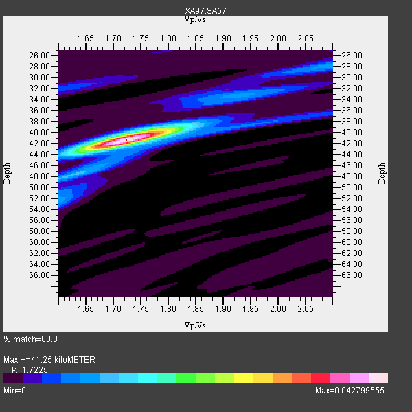
| Thickness Estimate: | 41 km |
| Thickness StdDev: | 0.3 km |
| Vp/Vs Estimate: | 1.72 |
| Vp/Vs StdDev: | 0.01 |
| Vs Estimate: | 3.856 km/s |
| Poisson's Ratio: | 0.25 |
| Peak Value: | 0.04 |
| Assumed Vp: | 6.642 km/s |
| Ps Weight: | 0.33333334 |
| PpPs Weight: | 0.33333334 |
| PsPs Weight: | 0.33333328 |
| Residual Complexity: | 0.287 |
| Nearby stations H: | +- |
| (2.0 deg) Vp/Vs: | +- |
7 with match > 90% ( 14.893617 %) and 13 with match > 80% ( 27.659575 %) out of 47.
Download stack as xyz text file.
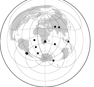
Azimuth Distribution of Events:
Prior Results for this Station
| Study | Thickness | Vp/Vs | Vp | Vs | Poissons Ratio | Extra |
| EARS | 41 km | 1.72 | 6.642 km/s | 3.856 km/s | 0.25 | |
| Crust2.0 | 43 km | 1.77 | 6.642 km/s | 3.756 km/s | 0.26 | I1,late Proter., no seds. |
| Global Maxima | 41 km | 1.72 | 6.642 km/s | 3.856 km/s | 0.25 | amp=0.042799555 |
| Local Maxima 1 | 40 km | 1.75 | 6.642 km/s | 3.785 km/s | 0.26 | amp=0.010245746 |
| Local Maxima 2 | 52 km | 1.60 | 6.642 km/s | 4.151 km/s | 0.18 | amp=0.009149388 |
| Local Maxima 3 | 28 km | 2.10 | 6.642 km/s | 3.167 km/s | 0.35 | amp=0.008538884 |
| Local Maxima 4 | 32 km | 1.61 | 6.642 km/s | 4.119 km/s | 0.19 | amp=0.004828571 |
| Predicted Arrivals for vertical incidence (zero ray parameter) | |
| Ps | 4.49 SECOND |
| PpPs | 16.91 SECOND |
| PsPs/PpSs | 21.40 SECOND |
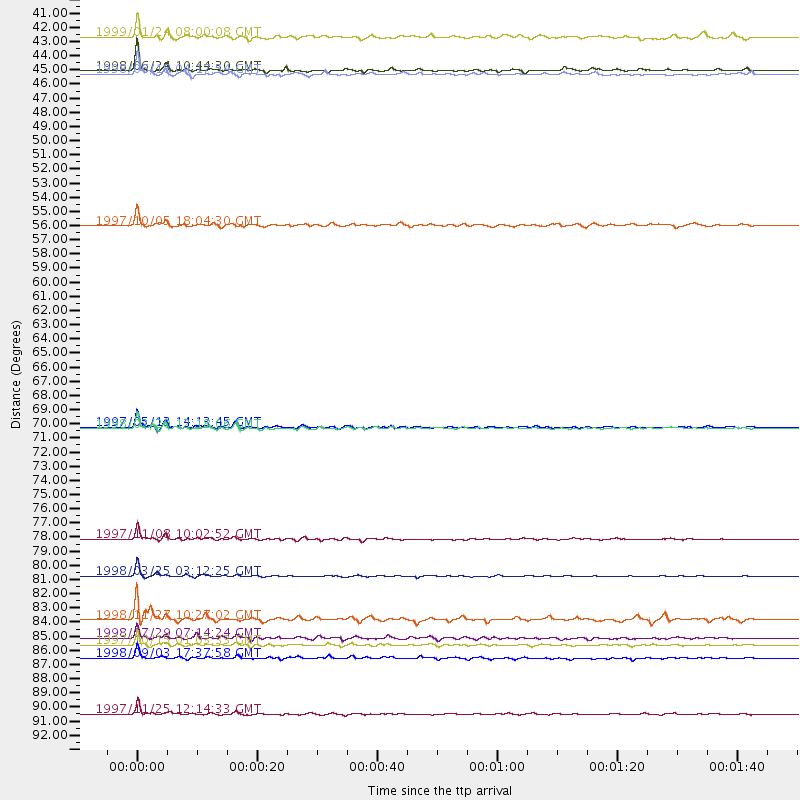
Events Processed for this Station
Download zip of receiver functions as SAC
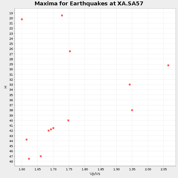
Plot maxima for each earthquake.
Events Used in the Stack
(13 events)| Radial Match | Distance | Baz | FERegion | Time | Lat/Lon | Depth | Magnitude |
| 98.577065 | 82.1 deg | 156.254 deg | Balleny Islands Region | 1998/03/25 03:12:25 GMT | (-62.9, 149.5) | 10 km | 6.6 MB, 8.0 MS, 8.3 UNKNOWN, 8.1 MW |
| 97.82799 | 87.5 deg | 237.525 deg | Near Coast Of Central Chile | 1997/10/15 01:03:33 GMT | (-30.9, -71.2) | 58 km | 6.8 MB, 6.8 MS, 7.3 UNKNOWN, 7.1 MW |
| 96.12839 | 79.3 deg | 44.636 deg | Xizang | 1997/11/08 10:02:52 GMT | (35.1, 87.3) | 33 km | 6.2 MB, 7.9 MS, 7.7 UNKNOWN, 7.6 MW |
| 94.66442 | 70.6 deg | 34.074 deg | Hindu Kush Region, Afghanistan | 1997/05/13 14:13:45 GMT | (36.4, 70.9) | 196 km | 6.1 MB, 6.5 UNKNOWN, 6.4 MW |
| 93.47158 | 88.5 deg | 238.678 deg | Near Coast Of Central Chile | 1998/09/03 17:37:58 GMT | (-29.5, -71.7) | 27 km | 6.2 MB, 6.6 MS, 6.5 UNKNOWN, 6.4 ME |
| 92.194084 | 92.8 deg | 89.84 deg | Minahassa Peninsula, Sulawesi | 1997/11/25 12:14:33 GMT | (1.2, 122.5) | 24 km | 6.1 MB, 6.8 MS, 7.1 UNKNOWN, 6.7 ME |
| 91.23087 | 43.0 deg | 239.452 deg | Southern Mid-Atlantic Ridge | 1998/06/24 10:44:30 GMT | (-37.3, -17.4) | 10 km | 5.7 MB, 5.8 MS, 6.0 UNKNOWN, 5.9 MW |
| 87.8339 | 85.5 deg | 237.106 deg | Mendoza Province, Argentina | 1998/11/27 10:27:02 GMT | (-32.1, -69.3) | 127 km | 5.2 MB, 5.5 UNKNOWN, 5.3 MD |
| 87.53557 | 70.7 deg | 34.12 deg | Afghanistan-Tajikistan Bord Reg. | 1998/02/20 12:18:06 GMT | (36.5, 71.1) | 236 km | 5.8 MB, 5.7 MS, 6.4 UNKNOWN, 6.3 MW |
| 84.996254 | 86.9 deg | 236.256 deg | Near Coast Of Central Chile | 1998/07/29 07:14:24 GMT | (-32.3, -71.3) | 51 km | 6.3 MB, 6.5 UNKNOWN, 6.5 ME |
| 84.90102 | 55.0 deg | 212.086 deg | South Sandwich Islands Region | 1997/10/05 18:04:30 GMT | (-59.7, -29.2) | 274 km | 6.0 MB, 6.3 UNKNOWN, 6.3 MW |
| 84.253624 | 43.3 deg | 277.574 deg | Ascension Island Region | 1998/06/18 04:17:54 GMT | (-11.6, -13.9) | 10 km | 6.1 MS, 5.4 MB, 6.2 UNKNOWN |
| 84.20417 | 40.4 deg | 104.304 deg | Mid-Indian Ridge | 1999/01/24 08:00:08 GMT | (-26.5, 74.5) | 10 km | 6.0 MB, 6.3 MS, 6.3 MW, 6.3 ME |
Losers
(34 events)| Radial Match | Distance | Baz | FERegion | Time | Lat/Lon | Depth | Magnitude | Reason |
| 78.312416 | 87.6 deg | 237.409 deg | Near Coast Of Central Chile | 1998/01/12 10:14:07 GMT | (-31.0, -71.4) | 35 km | 5.8 MB, 6.2 MS, 6.6 UNKNOWN, 6.2 ME | |
| 75.89731 | 57.4 deg | 28.556 deg | Southern Iran | 1999/03/04 05:38:26 GMT | (28.3, 57.2) | 33 km | 6.2 MB, 6.5 MS, 6.6 MW, 6.4 MW | |
| 74.880905 | 59.5 deg | 352.559 deg | Southern Greece | 1997/10/13 13:39:37 GMT | (36.4, 22.1) | 24 km | 6.2 MB, 6.6 MS, 6.7 UNKNOWN, 6.5 MW | |
| 74.517235 | 80.9 deg | 318.264 deg | Azores Islands, Portugal | 1997/06/27 04:39:52 GMT | (38.3, -26.7) | 10 km | 5.6 MB, 5.4 MS, 5.9 UNKNOWN, 5.9 MW | |
| 74.48029 | 84.3 deg | 230.987 deg | S. Chile-Argentina Border Region | 1998/12/14 16:25:24 GMT | (-38.2, -71.0) | 138 km | 6.0 UNKNOWN, 4.8 MS, 5.4 MB | |
| 73.16323 | 70.7 deg | 33.058 deg | Afghanistan-Tajikistan Bord Reg. | 1998/05/30 06:22:28 GMT | (37.1, 70.1) | 33 km | 5.9 MB, 6.9 MS, 6.6 UNKNOWN, 6.5 MW | |
| 72.43603 | 35.5 deg | 81.438 deg | Mid-Indian Ridge | 1997/09/25 14:20:48 GMT | (-13.8, 66.2) | 10 km | 5.3 MB, 5.7 MS, 6.0 UNKNOWN, 6.0 MW | |
| 71.33476 | 62.1 deg | 28.529 deg | Northern And Central Iran | 1998/04/10 15:00:53 GMT | (32.5, 60.0) | 33 km | 5.7 MS, 5.3 MB, 5.8 UNKNOWN, 5.6 MW | |
| 71.20376 | 95.5 deg | 99.839 deg | Banda Sea | 1998/11/09 05:38:44 GMT | (-6.9, 128.9) | 33 km | 6.4 MB, 7.0 MS, 7.3 UNKNOWN, 7.0 MW | |
| 68.94494 | 79.9 deg | 94.639 deg | Java, Indonesia | 1998/09/28 13:34:30 GMT | (-8.2, 112.4) | 152 km | 6.4 MB, 6.5 UNKNOWN, 6.5 MW | |
| 67.67344 | 49.3 deg | 289.274 deg | North Of Ascension Island | 1998/04/10 16:40:38 GMT | (-1.3, -15.7) | 10 km | 5.9 MS, 5.4 MB, 6.2 UNKNOWN, 6.1 MW | |
| 66.5706 | 52.9 deg | 216.536 deg | South Sandwich Islands Region | 1998/08/29 08:30:21 GMT | (-55.7, -27.0) | 33 km | 5.6 MB, 5.6 MS, 6.0 UNKNOWN, 5.9 MW | |
| 65.25458 | 70.7 deg | 34.054 deg | Afghanistan-Tajikistan Bord Reg. | 1998/12/11 20:16:24 GMT | (36.5, 71.0) | 223 km | 5.7 UNKNOWN, 5.0 MB, 5.6 MW | |
| 65.21825 | 85.0 deg | 155.296 deg | West Of Macquarie Island | 1998/06/29 23:37:16 GMT | (-60.4, 153.1) | 10 km | 5.8 MS, 5.0 MB, 6.3 UNKNOWN, 6.0 MW | |
| 65.05322 | 58.9 deg | 351.474 deg | Central Mediterranean Sea | 1997/07/27 10:07:52 GMT | (35.6, 21.1) | 33 km | 5.5 MB, 4.8 MS, 5.6 UNKNOWN, 5.2 ML | |
| 64.39576 | 88.7 deg | 245.978 deg | Northern Chile | 1999/03/02 17:45:55 GMT | (-22.7, -68.5) | 111 km | 5.8 MB, 6.1 MW, 5.9 MW | |
| 64.387245 | 89.7 deg | 90.289 deg | Minahassa Peninsula, Sulawesi | 1998/10/10 16:29:08 GMT | (-0.4, 119.9) | 33 km | 5.5 MS, 5.4 MB, 6.1 UNKNOWN | |
| 64.173676 | 95.6 deg | 76.508 deg | Luzon, Philippines | 1998/08/23 05:36:12 GMT | (14.7, 120.0) | 70 km | 6.1 MB, 6.1 UNKNOWN, 6.0 MW | |
| 63.466377 | 97.2 deg | 86.879 deg | Mindanao, Philippines | 1997/10/05 19:00:02 GMT | (5.7, 125.5) | 224 km | 5.6 MB, 5.8 UNKNOWN | |
| 63.16497 | 93.4 deg | 173.524 deg | Pacific-Antarctic Ridge | 1997/09/12 14:09:03 GMT | (-63.1, -164.3) | 10 km | 5.6 MS, 5.0 MB, 5.8 UNKNOWN, 5.8 MW | |
| 62.994106 | 41.9 deg | 242.01 deg | Southern Mid-Atlantic Ridge | 1998/01/03 06:10:08 GMT | (-35.5, -16.2) | 10 km | 5.9 MS, 5.4 MB, 6.3 UNKNOWN, 6.1 MW | |
| 62.961063 | 86.7 deg | 246.558 deg | Jujuy Province, Argentina | 1997/07/20 10:14:22 GMT | (-23.0, -66.3) | 256 km | 5.7 MB, 6.1 UNKNOWN, 5.7 ME | |
| 62.34041 | 37.5 deg | 80.015 deg | Mid-Indian Ridge | 1998/04/09 23:26:52 GMT | (-12.2, 67.8) | 10 km | 5.5 MB, 5.4 MS, 5.9 UNKNOWN, 5.9 MW | |
| 61.777172 | 76.4 deg | 35.728 deg | Southern Xinjiang, China | 1998/08/27 09:03:36 GMT | (39.7, 77.3) | 33 km | 5.6 MB, 6.4 MS, 6.3 UNKNOWN, 6.3 MW | |
| 60.716675 | 89.6 deg | 248.281 deg | Chile-Bolivia Border Region | 1997/12/09 14:23:45 GMT | (-20.2, -68.4) | 133 km | 5.7 MB, 5.7 UNKNOWN, 5.7 MW | |
| 59.13848 | 69.0 deg | 75.968 deg | Northern Sumatra, Indonesia | 1999/02/04 19:28:00 GMT | (4.0, 95.3) | 56 km | 5.8 MB, 5.4 MS, 5.9 MW, 5.9 MW | |
| 58.488636 | 96.1 deg | 98.456 deg | Banda Sea | 1997/09/26 15:48:34 GMT | (-5.4, 129.0) | 254 km | 5.8 MB, 6.0 UNKNOWN, 6.0 MW | |
| 56.95679 | 92.6 deg | 254.005 deg | Peru-Bolivia Border Region | 1997/11/28 22:53:41 GMT | (-13.7, -68.8) | 586 km | 6.4 MB, 6.6 UNKNOWN, 6.6 MW | |
| 56.069572 | 96.6 deg | 97.659 deg | Banda Sea | 1998/02/19 14:14:51 GMT | (-4.5, 129.1) | 33 km | 6.1 MB, 6.4 MS, 6.5 UNKNOWN, 6.5 MW | |
| 55.75721 | 86.8 deg | 160.441 deg | Balleny Islands Region | 1997/12/16 07:06:56 GMT | (-62.9, 163.2) | 10 km | 5.6 MS, 4.7 MB | |
| 53.672367 | 79.3 deg | 91.688 deg | Java Sea | 1997/07/11 09:55:12 GMT | (-5.7, 110.8) | 574 km | 5.6 MB | |
| 52.852604 | 84.6 deg | 151.411 deg | West Of Macquarie Island | 1997/10/17 09:55:15 GMT | (-57.5, 148.0) | 10 km | 5.2 MB, 5.9 MS, 6.2 UNKNOWN, 6.0 MW | |
| 48.06294 | 70.7 deg | 33.065 deg | Afghanistan-Tajikistan Bord Reg. | 1998/02/04 14:33:21 GMT | (37.1, 70.1) | 33 km | 5.6 MB, 6.1 MS, 6.0 UNKNOWN, 5.9 MW | |
| 44.458035 | 96.8 deg | 97.327 deg | Banda Sea | 1998/01/13 09:50:11 GMT | (-4.1, 129.1) | 44 km | 5.9 MB, 5.5 MS, 5.9 UNKNOWN, 5.8 MW |
