
Station XA SA58 - XA.SA58
Network: XA97 - Anatomy of an Archean Craton, South Africa
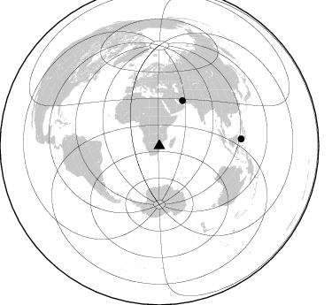
Nearby stations (2 deg radius)
| Station | Name | (Lat, Lon) | Start / End | Elevation |
| SA58 | XA.SA58 | (-23.52, 31.40) | 1998-10-15 / 1999-12-31 | 356 m |
| Crust2 Type: | I1,late Proter., no seds. |
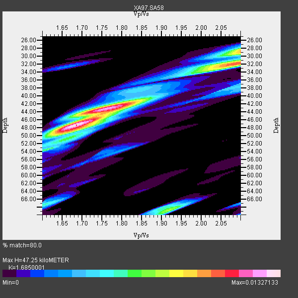
| Thickness Estimate: | 47 km |
| Thickness StdDev: | 3.5 km |
| Vp/Vs Estimate: | 1.69 |
| Vp/Vs StdDev: | 0.06 |
| Vs Estimate: | 3.942 km/s |
| Poisson's Ratio: | 0.23 |
| Peak Value: | 0.01 |
| Assumed Vp: | 6.642 km/s |
| Ps Weight: | 0.33333334 |
| PpPs Weight: | 0.33333334 |
| PsPs Weight: | 0.33333328 |
| Residual Complexity: | 0.733 |
| Nearby stations H: | +- |
| (2.0 deg) Vp/Vs: | +- |
0 with match > 90% ( 0.0 %) and 2 with match > 80% ( 28.571428 %) out of 7.
Download stack as xyz text file.
Azimuth Distribution of Events:
Prior Results for this Station
| Study | Thickness | Vp/Vs | Vp | Vs | Poissons Ratio | Extra |
| EARS | 47 km | 1.69 | 6.642 km/s | 3.942 km/s | 0.23 | |
| Crust2.0 | 43 km | 1.77 | 6.642 km/s | 3.756 km/s | 0.26 | I1,late Proter., no seds. |
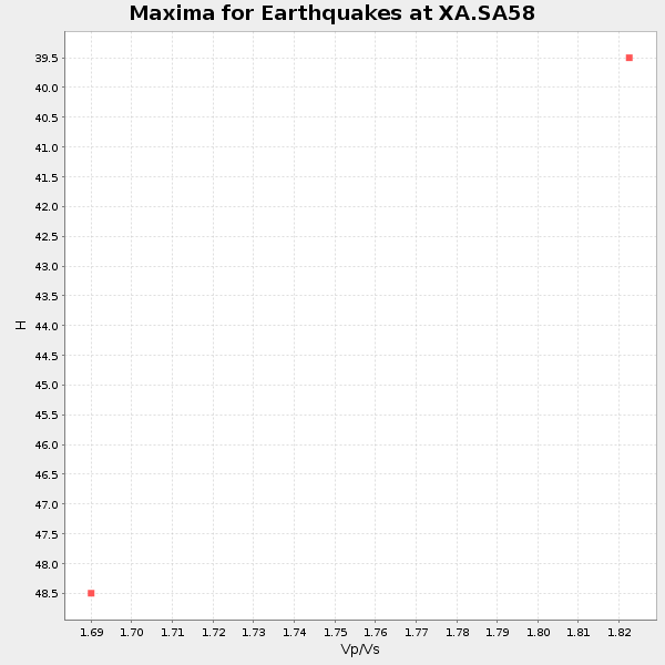
| Global Maxima | 47 km | 1.69 | 6.642 km/s | 3.942 km/s | 0.23 | amp=0.01327133 |
| Local Maxima 1 | 43 km | 1.78 | 6.642 km/s | 3.731 km/s | 0.27 | amp=0.011033941 |
| Local Maxima 2 | 32 km | 2.09 | 6.642 km/s | 3.178 km/s | 0.35 | amp=0.0100433035 |
| Local Maxima 3 | 29 km | 2.10 | 6.642 km/s | 3.167 km/s | 0.35 | amp=0.007822457 |
| Local Maxima 4 | 69 km | 1.91 | 6.642 km/s | 3.468 km/s | 0.31 | amp=0.0074294666 |
| Predicted Arrivals for vertical incidence (zero ray parameter) | |
| Ps | 4.87 SECOND |
| PpPs | 19.10 SECOND |
| PsPs/PpSs | 23.97 SECOND |
Events Processed for this Station
Download zip of receiver functions as SAC
Plot maxima for each earthquake.
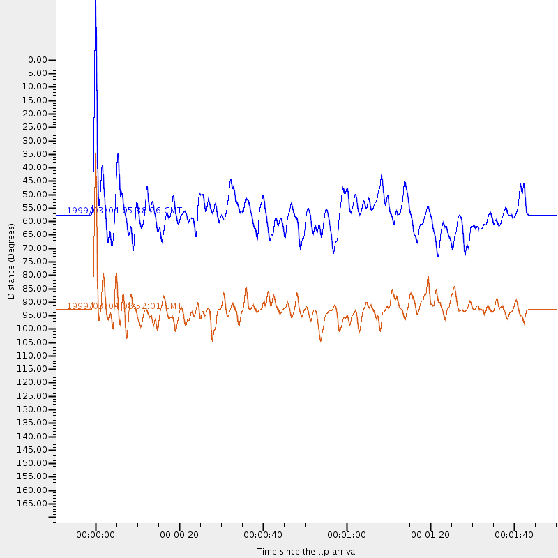
Events Used in the Stack
(2 events)| Radial Match | Distance | Baz | FERegion | Time | Lat/Lon | Depth | Magnitude |
| 89.174866 | 92.6 deg | 85.289 deg | Celebes Sea | 1999/03/04 08:52:01 GMT | (5.4, 121.9) | 33 km | 6.4 MB, 6.5 MS, 7.1 MW, 7.1 MW |
| 84.526146 | 57.2 deg | 27.136 deg | Southern Iran | 1999/03/04 05:38:26 GMT | (28.3, 57.2) | 33 km | 6.2 MB, 6.5 MS, 6.6 MW, 6.4 MW |
Losers
(5 events)| Radial Match | Distance | Baz | FERegion | Time | Lat/Lon | Depth | Magnitude | Reason |
| 70.909996 | 89.6 deg | 245.452 deg | Northern Chile | 1999/03/02 17:45:55 GMT | (-22.7, -68.5) | 111 km | 5.8 MB, 6.1 MW, 5.9 MW | |
| 51.23177 | 39.0 deg | 103.505 deg | Mid-Indian Ridge | 1999/01/24 08:00:08 GMT | (-26.5, 74.5) | 10 km | 6.0 MB, 6.3 MS, 6.3 MW, 6.3 ME | |
| 44.238117 | 86.4 deg | 98.35 deg | Savu Sea | 1998/11/08 07:25:48 GMT | (-9.1, 121.4) | 33 km | 6.0 MB, 5.9 MS, 6.4 UNKNOWN, 5.7 ME | |
| 44.17574 | 75.0 deg | 89.876 deg | Java, Indonesia | 1999/03/07 01:32:27 GMT | (-5.8, 107.6) | 325 km | 5.6 MW, 5.0 MB | |
| 39.057617 | 92.8 deg | 85.51 deg | Celebes Sea | 1999/03/05 13:01:10 GMT | (5.3, 122.2) | 33 km | 5.6 MB, 5.1 MS, 5.7 MW, 5.7 MW |
