
Station XA SA60 - XA.SA60
Network: XA97 - Anatomy of an Archean Craton, South Africa
Nearby stations (2 deg radius)
| Station | Name | (Lat, Lon) | Start / End | Elevation |
| SA60 | XA.SA60 | (-23.85, 24.96) | 1997-04-25 / 1999-12-31 | 1043 m |
| Crust2 Type: | G1,Archean, no seds. |
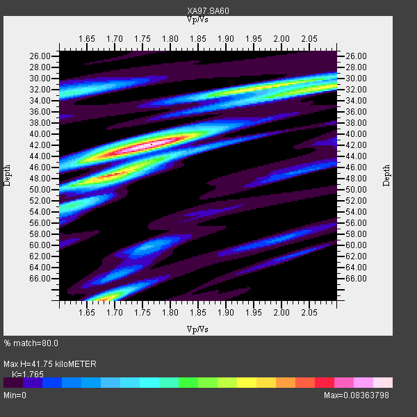
| Thickness Estimate: | 42 km |
| Thickness StdDev: | 8.6 km |
| Vp/Vs Estimate: | 1.76 |
| Vp/Vs StdDev: | 0.12 |
| Vs Estimate: | 3.66 km/s |
| Poisson's Ratio: | 0.26 |
| Peak Value: | 0.08 |
| Assumed Vp: | 6.459 km/s |
| Ps Weight: | 0.33333334 |
| PpPs Weight: | 0.33333334 |
| PsPs Weight: | 0.33333328 |
| Residual Complexity: | 0.663 |
| Nearby stations H: | +- |
| (2.0 deg) Vp/Vs: | +- |
3 with match > 90% ( 15.789474 %) and 6 with match > 80% ( 31.578947 %) out of 19.
Download stack as xyz text file.
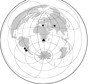
Azimuth Distribution of Events:
Prior Results for this Station
| Study | Thickness | Vp/Vs | Vp | Vs | Poissons Ratio | Extra |
| EARS | 42 km | 1.76 | 6.459 km/s | 3.66 km/s | 0.26 | |
| Crust2.0 | 37 km | 1.76 | 6.459 km/s | 3.665 km/s | 0.26 | G1,Archean, no seds. |
| Global Maxima | 42 km | 1.76 | 6.459 km/s | 3.66 km/s | 0.26 | amp=0.08363798 |
| Local Maxima 1 | 70 km | 1.68 | 6.459 km/s | 3.851 km/s | 0.22 | amp=0.062866986 |
| Local Maxima 2 | 32 km | 1.97 | 6.459 km/s | 3.279 km/s | 0.33 | amp=0.05350901 |
| Local Maxima 3 | 47 km | 1.70 | 6.459 km/s | 3.794 km/s | 0.24 | amp=0.050524063 |
| Local Maxima 4 | 31 km | 2.10 | 6.459 km/s | 3.08 km/s | 0.35 | amp=0.043528367 |
| Predicted Arrivals for vertical incidence (zero ray parameter) | |
| Ps | 4.94 SECOND |
| PpPs | 17.87 SECOND |
| PsPs/PpSs | 22.82 SECOND |
Events Processed for this Station
Download zip of receiver functions as SAC
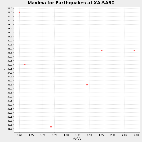
Plot maxima for each earthquake.
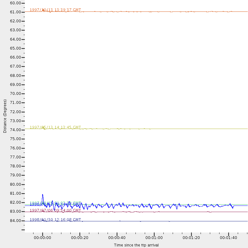
Events Used in the Stack
(6 events)| Radial Match | Distance | Baz | FERegion | Time | Lat/Lon | Depth | Magnitude |
| 97.6029 | 83.1 deg | 239.386 deg | Near Coast Of Central Chile | 1997/10/15 01:03:33 GMT | (-30.9, -71.2) | 58 km | 6.8 MB, 6.8 MS, 7.3 UNKNOWN, 7.1 MW |
| 96.688965 | 85.0 deg | 246.19 deg | Near Coast Of Northern Chile | 1998/01/30 12:16:08 GMT | (-23.9, -70.2) | 42 km | 6.3 MB, 6.5 MS, 7.0 UNKNOWN, 6.7 ME |
| 90.14635 | 74.0 deg | 37.121 deg | Hindu Kush Region, Afghanistan | 1997/05/13 14:13:45 GMT | (36.4, 70.9) | 196 km | 6.1 MB, 6.5 UNKNOWN, 6.4 MW |
| 89.80602 | 83.2 deg | 239.272 deg | Near Coast Of Central Chile | 1998/01/12 10:14:07 GMT | (-31.0, -71.4) | 35 km | 5.8 MB, 6.2 MS, 6.6 UNKNOWN, 6.2 ME |
| 82.37185 | 60.0 deg | 357.308 deg | Southern Greece | 1997/10/13 13:39:37 GMT | (36.4, 22.1) | 24 km | 6.2 MB, 6.6 MS, 6.7 UNKNOWN, 6.5 MW |
| 80.54462 | 83.9 deg | 239.962 deg | Near Coast Of Central Chile | 1997/07/06 09:54:00 GMT | (-30.1, -71.9) | 19 km | 5.8 MB, 6.5 MS, 6.8 UNKNOWN, 6.4 ME |
Losers
(13 events)| Radial Match | Distance | Baz | FERegion | Time | Lat/Lon | Depth | Magnitude | Reason |
| 77.82041 | 97.4 deg | 91.925 deg | Minahassa Peninsula, Sulawesi | 1997/11/25 12:14:33 GMT | (1.2, 122.5) | 24 km | 6.1 MB, 6.8 MS, 7.1 UNKNOWN, 6.7 ME | |
| 71.03037 | 84.1 deg | 240.74 deg | Near Coast Of Central Chile | 1997/07/19 12:22:57 GMT | (-29.3, -71.7) | 26 km | 5.8 MB, 5.5 MS, 5.9 UNKNOWN, 5.8 MW | |
| 66.73823 | 84.1 deg | 248.219 deg | Northern Chile | 1997/09/28 23:13:13 GMT | (-22.4, -68.4) | 107 km | 5.7 MB, 5.6 UNKNOWN, 5.6 MW | |
| 66.62064 | 78.6 deg | 321.009 deg | Azores Islands, Portugal | 1997/06/27 04:39:52 GMT | (38.3, -26.7) | 10 km | 5.6 MB, 5.4 MS, 5.9 UNKNOWN, 5.9 MW | |
| 66.39303 | 51.8 deg | 211.49 deg | South Sandwich Islands Region | 1997/10/05 18:04:30 GMT | (-59.7, -29.2) | 274 km | 6.0 MB, 6.3 UNKNOWN, 6.3 MW | |
| 64.943565 | 93.0 deg | 175.791 deg | Pacific-Antarctic Ridge | 1997/09/12 14:09:03 GMT | (-63.1, -164.3) | 10 km | 5.6 MS, 5.0 MB, 5.8 UNKNOWN, 5.8 MW | |
| 62.773678 | 84.9 deg | 250.242 deg | Chile-Bolivia Border Region | 1997/12/09 14:23:45 GMT | (-20.2, -68.4) | 133 km | 5.7 MB, 5.7 UNKNOWN, 5.7 MW | |
| 61.45935 | 71.0 deg | 53.005 deg | Southern India | 1997/05/21 22:51:28 GMT | (23.1, 80.0) | 36 km | 6.0 MB, 5.6 MS, 5.8 UNKNOWN, 5.6 ME | |
| 56.59271 | 87.9 deg | 256.007 deg | Peru-Bolivia Border Region | 1997/11/28 22:53:41 GMT | (-13.7, -68.8) | 586 km | 6.4 MB, 6.6 UNKNOWN, 6.6 MW | |
| 56.058163 | 83.9 deg | 93.531 deg | Java Sea | 1997/07/11 09:55:12 GMT | (-5.7, 110.8) | 574 km | 5.6 MB | |
| 51.85962 | 83.2 deg | 243.462 deg | Northern Chile | 1997/05/17 02:10:18 GMT | (-27.2, -69.5) | 106 km | 5.5 MB, 5.6 UNKNOWN, 5.5 MW | |
| 50.04776 | 83.2 deg | 239.494 deg | Near Coast Of Central Chile | 1997/11/03 20:12:52 GMT | (-30.8, -71.3) | 45 km | 5.6 MB, 5.2 MD | |
| 44.95406 | 82.1 deg | 248.463 deg | Jujuy Province, Argentina | 1997/07/20 10:14:22 GMT | (-23.0, -66.3) | 256 km | 5.7 MB, 6.1 UNKNOWN, 5.7 ME |
