
Station XA SA61 - XA.SA61
Network: XA97 - Anatomy of an Archean Craton, South Africa
Nearby stations (2 deg radius)
| Station | Name | (Lat, Lon) | Start / End | Elevation |
| SA61 | XA.SA61 | (-23.95, 24.02) | 1997-04-24 / 1999-12-31 | 1069 m |
| Crust2 Type: | G1,Archean, no seds. |
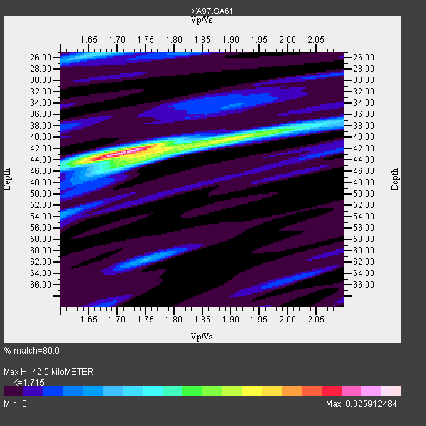
| Thickness Estimate: | 42 km |
| Thickness StdDev: | 5.3 km |
| Vp/Vs Estimate: | 1.72 |
| Vp/Vs StdDev: | 0.06 |
| Vs Estimate: | 3.766 km/s |
| Poisson's Ratio: | 0.24 |
| Peak Value: | 0.03 |
| Assumed Vp: | 6.459 km/s |
| Ps Weight: | 0.33333334 |
| PpPs Weight: | 0.33333334 |
| PsPs Weight: | 0.33333328 |
| Residual Complexity: | 0.505 |
| Nearby stations H: | +- |
| (2.0 deg) Vp/Vs: | +- |
4 with match > 90% ( 20.0 %) and 10 with match > 80% ( 50.0 %) out of 20.
Download stack as xyz text file.
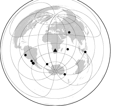
Azimuth Distribution of Events:
Prior Results for this Station
| Study | Thickness | Vp/Vs | Vp | Vs | Poissons Ratio | Extra |
| EARS | 42 km | 1.72 | 6.459 km/s | 3.766 km/s | 0.24 | |
| Crust2.0 | 37 km | 1.76 | 6.459 km/s | 3.665 km/s | 0.26 | G1,Archean, no seds. |
| Global Maxima | 42 km | 1.72 | 6.459 km/s | 3.766 km/s | 0.24 | amp=0.025912484 |
| Local Maxima 1 | 43 km | 1.76 | 6.459 km/s | 3.66 km/s | 0.26 | amp=0.011208272 |
| Local Maxima 2 | 25 km | 1.68 | 6.459 km/s | 3.851 km/s | 0.22 | amp=0.008769402 |
| Local Maxima 3 | 40 km | 1.92 | 6.459 km/s | 3.364 km/s | 0.31 | amp=0.008397576 |
| Local Maxima 4 | 62 km | 1.75 | 6.459 km/s | 3.691 km/s | 0.26 | amp=0.0066357804 |
| Predicted Arrivals for vertical incidence (zero ray parameter) | |
| Ps | 4.70 SECOND |
| PpPs | 17.86 SECOND |
| PsPs/PpSs | 22.57 SECOND |
Events Processed for this Station
Download zip of receiver functions as SAC
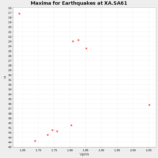
Plot maxima for each earthquake.
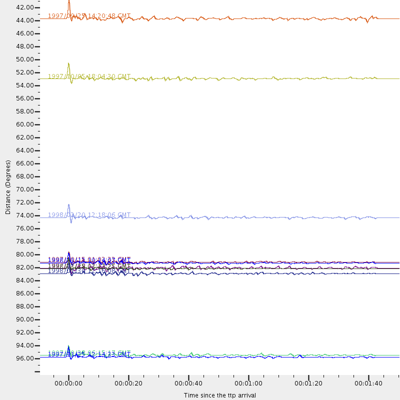
Events Used in the Stack
(10 events)| Radial Match | Distance | Baz | FERegion | Time | Lat/Lon | Depth | Magnitude |
| 98.07531 | 83.4 deg | 157.938 deg | Balleny Islands Region | 1998/03/25 03:12:25 GMT | (-62.9, 149.5) | 10 km | 6.6 MB, 8.0 MS, 8.3 UNKNOWN, 8.1 MW |
| 96.39563 | 84.2 deg | 246.543 deg | Near Coast Of Northern Chile | 1998/01/30 12:16:08 GMT | (-23.9, -70.2) | 42 km | 6.3 MB, 6.5 MS, 7.0 UNKNOWN, 6.7 ME |
| 96.29871 | 82.3 deg | 239.718 deg | Near Coast Of Central Chile | 1997/10/15 01:03:33 GMT | (-30.9, -71.2) | 58 km | 6.8 MB, 6.8 MS, 7.3 UNKNOWN, 7.1 MW |
| 94.91232 | 82.4 deg | 239.605 deg | Near Coast Of Central Chile | 1998/01/12 10:14:07 GMT | (-31.0, -71.4) | 35 km | 5.8 MB, 6.2 MS, 6.6 UNKNOWN, 6.2 ME |
| 85.957985 | 74.7 deg | 37.71 deg | Afghanistan-Tajikistan Bord Reg. | 1998/02/20 12:18:06 GMT | (36.5, 71.1) | 236 km | 5.8 MB, 5.7 MS, 6.4 UNKNOWN, 6.3 MW |
| 85.33312 | 41.1 deg | 83.521 deg | Mid-Indian Ridge | 1997/09/25 14:20:48 GMT | (-13.8, 66.2) | 10 km | 5.3 MB, 5.7 MS, 6.0 UNKNOWN, 6.0 MW |
| 84.66259 | 98.0 deg | 261.641 deg | Northern Peru | 1997/10/28 06:15:17 GMT | (-4.4, -76.7) | 112 km | 6.6 MB, 6.3 MS, 7.2 UNKNOWN, 6.6 ME |
| 84.05912 | 51.3 deg | 211.326 deg | South Sandwich Islands Region | 1997/10/05 18:04:30 GMT | (-59.7, -29.2) | 274 km | 6.0 MB, 6.3 UNKNOWN, 6.3 MW |
| 80.88916 | 98.3 deg | 92.32 deg | Minahassa Peninsula, Sulawesi | 1997/11/25 12:14:33 GMT | (1.2, 122.5) | 24 km | 6.1 MB, 6.8 MS, 7.1 UNKNOWN, 6.7 ME |
| 80.38523 | 83.3 deg | 241.081 deg | Near Coast Of Central Chile | 1997/07/19 12:22:57 GMT | (-29.3, -71.7) | 26 km | 5.8 MB, 5.5 MS, 5.9 UNKNOWN, 5.8 MW |
Losers
(10 events)| Radial Match | Distance | Baz | FERegion | Time | Lat/Lon | Depth | Magnitude | Reason |
| 94.91654 | 74.5 deg | 37.587 deg | Hindu Kush Region, Afghanistan | 1997/12/17 05:51:29 GMT | (36.4, 70.8) | 207 km | 5.5 MB, 6.3 UNKNOWN | |
| 74.70467 | 87.0 deg | 256.38 deg | Peru-Bolivia Border Region | 1997/11/28 22:53:41 GMT | (-13.7, -68.8) | 586 km | 6.4 MB, 6.6 UNKNOWN, 6.6 MW | |
| 72.90401 | 93.0 deg | 176.214 deg | Pacific-Antarctic Ridge | 1997/09/12 14:09:03 GMT | (-63.1, -164.3) | 10 km | 5.6 MS, 5.0 MB, 5.8 UNKNOWN, 5.8 MW | |
| 72.1053 | 36.5 deg | 242.271 deg | Southern Mid-Atlantic Ridge | 1998/01/03 06:10:08 GMT | (-35.5, -16.2) | 10 km | 5.9 MS, 5.4 MB, 6.3 UNKNOWN, 6.1 MW | |
| 70.65283 | 83.0 deg | 239.917 deg | Near Coast Of Central Chile | 1997/07/25 06:47:02 GMT | (-30.5, -71.9) | 33 km | 5.6 MB, 5.5 MS, 6.3 UNKNOWN | |
| 65.03107 | 81.3 deg | 248.808 deg | Jujuy Province, Argentina | 1997/07/20 10:14:22 GMT | (-23.0, -66.3) | 256 km | 5.7 MB, 6.1 UNKNOWN, 5.7 ME | |
| 64.641266 | 83.3 deg | 248.571 deg | Northern Chile | 1997/09/28 23:13:13 GMT | (-22.4, -68.4) | 107 km | 5.7 MB, 5.6 UNKNOWN, 5.6 MW | |
| 63.39673 | 84.8 deg | 93.893 deg | Java Sea | 1997/07/11 09:55:12 GMT | (-5.7, 110.8) | 574 km | 5.6 MB | |
| 58.870148 | 83.1 deg | 240.036 deg | Near Coast Of Central Chile | 1997/07/21 23:19:39 GMT | (-30.3, -71.9) | 33 km | 5.2 MB, 5.5 MS, 6.1 UNKNOWN | |
| 57.184906 | 84.1 deg | 250.601 deg | Chile-Bolivia Border Region | 1997/12/09 14:23:45 GMT | (-20.2, -68.4) | 133 km | 5.7 MB, 5.7 UNKNOWN, 5.7 MW |
