
Station XA SA62 - XA.SA62
Network: XA97 - Anatomy of an Archean Craton, South Africa
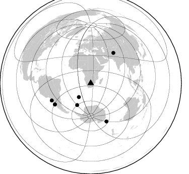
Nearby stations (2 deg radius)
| Station | Name | (Lat, Lon) | Start / End | Elevation |
| SA62 | XA.SA62 | (-24.85, 25.13) | 1997-04-23 / 1999-12-31 | 1214 m |
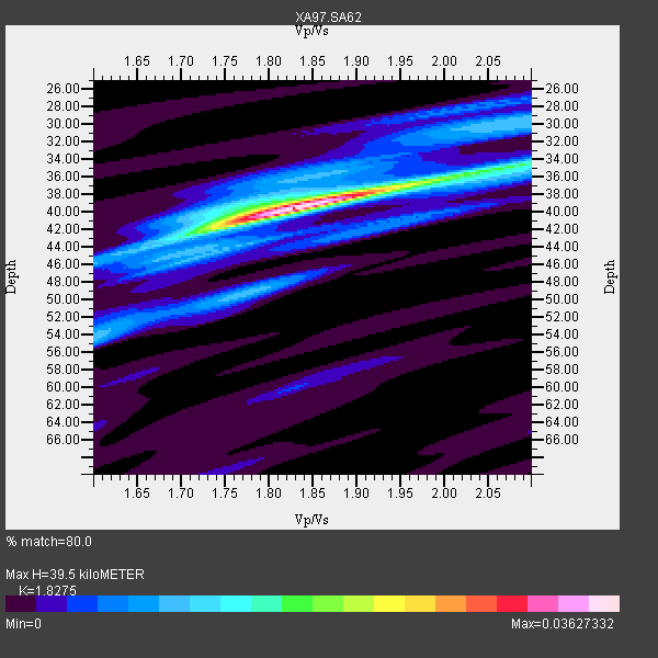
| Crust2 Type: | G1,Archean, no seds. |
| Thickness Estimate: | 40 km |
| Thickness StdDev: | 1.2 km |
| Vp/Vs Estimate: | 1.83 |
| Vp/Vs StdDev: | 0.03 |
| Vs Estimate: | 3.535 km/s |
| Poisson's Ratio: | 0.29 |
| Peak Value: | 0.04 |
| Assumed Vp: | 6.459 km/s |
| Ps Weight: | 0.33333334 |
| PpPs Weight: | 0.33333334 |
| PsPs Weight: | 0.33333328 |
| Residual Complexity: | 0.487 |
| Nearby stations H: | +- |
| (2.0 deg) Vp/Vs: | +- |
5 with match > 90% ( 29.411764 %) and 7 with match > 80% ( 41.17647 %) out of 17.
Download stack as xyz text file.
Azimuth Distribution of Events:
Prior Results for this Station
| Study | Thickness | Vp/Vs | Vp | Vs | Poissons Ratio | Extra |
| EARS | 40 km | 1.83 | 6.459 km/s | 3.535 km/s | 0.29 | |
| Crust2.0 | 37 km | 1.76 | 6.459 km/s | 3.665 km/s | 0.26 | G1,Archean, no seds. |
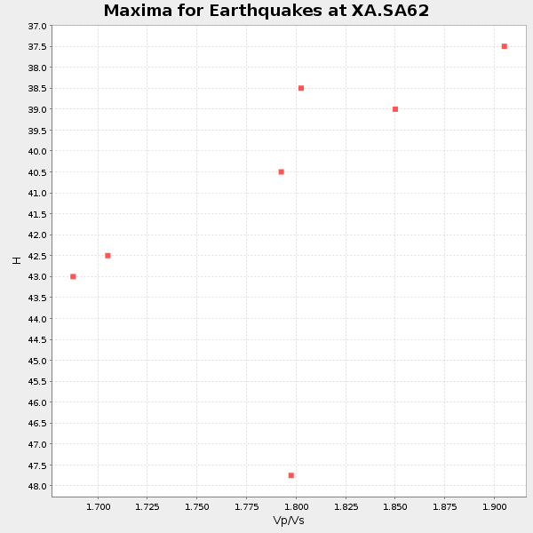
| Global Maxima | 40 km | 1.83 | 6.459 km/s | 3.535 km/s | 0.29 | amp=0.03627332 |
| Local Maxima 1 | 35 km | 2.06 | 6.459 km/s | 3.136 km/s | 0.35 | amp=0.015009746 |
| Local Maxima 2 | 42 km | 1.72 | 6.459 km/s | 3.755 km/s | 0.24 | amp=0.010670985 |
| Local Maxima 3 | 49 km | 1.77 | 6.459 km/s | 3.644 km/s | 0.27 | amp=0.009709297 |
| Local Maxima 4 | 30 km | 2.08 | 6.459 km/s | 3.113 km/s | 0.35 | amp=0.009431043 |
| Predicted Arrivals for vertical incidence (zero ray parameter) | |
| Ps | 5.06 SECOND |
| PpPs | 17.29 SECOND |
| PsPs/PpSs | 22.35 SECOND |
Events Processed for this Station
Download zip of receiver functions as SAC
Plot maxima for each earthquake.
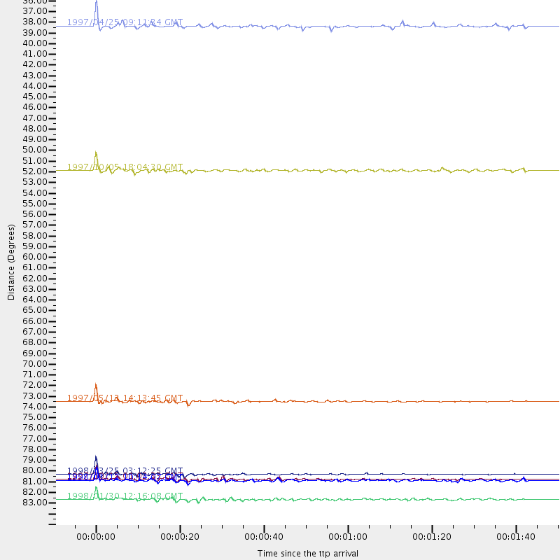
Events Used in the Stack
(7 events)| Radial Match | Distance | Baz | FERegion | Time | Lat/Lon | Depth | Magnitude |
| 99.03926 | 82.2 deg | 157.557 deg | Balleny Islands Region | 1998/03/25 03:12:25 GMT | (-62.9, 149.5) | 10 km | 6.6 MB, 8.0 MS, 8.3 UNKNOWN, 8.1 MW |
| 96.49322 | 82.7 deg | 239.431 deg | Near Coast Of Central Chile | 1997/10/15 01:03:33 GMT | (-30.9, -71.2) | 58 km | 6.8 MB, 6.8 MS, 7.3 UNKNOWN, 7.1 MW |
| 94.835785 | 84.8 deg | 246.205 deg | Near Coast Of Northern Chile | 1998/01/30 12:16:08 GMT | (-23.9, -70.2) | 42 km | 6.3 MB, 6.5 MS, 7.0 UNKNOWN, 6.7 ME |
| 94.46043 | 74.7 deg | 36.846 deg | Hindu Kush Region, Afghanistan | 1997/05/13 14:13:45 GMT | (36.4, 70.9) | 196 km | 6.1 MB, 6.5 UNKNOWN, 6.4 MW |
| 90.79702 | 82.8 deg | 239.315 deg | Near Coast Of Central Chile | 1998/01/12 10:14:07 GMT | (-31.0, -71.4) | 35 km | 5.8 MB, 6.2 MS, 6.6 UNKNOWN, 6.2 ME |
| 85.07554 | 36.2 deg | 220.575 deg | Southern Mid-Atlantic Ridge | 1997/04/25 09:11:34 GMT | (-48.3, -10.0) | 10 km | 5.8 MS, 5.3 MB, 5.8 UNKNOWN, 5.7 MW |
| 81.08816 | 51.0 deg | 211.944 deg | South Sandwich Islands Region | 1997/10/05 18:04:30 GMT | (-59.7, -29.2) | 274 km | 6.0 MB, 6.3 UNKNOWN, 6.3 MW |
Losers
(10 events)| Radial Match | Distance | Baz | FERegion | Time | Lat/Lon | Depth | Magnitude | Reason |
| 79.35909 | 97.2 deg | 91.98 deg | Minahassa Peninsula, Sulawesi | 1997/11/25 12:14:33 GMT | (1.2, 122.5) | 24 km | 6.1 MB, 6.8 MS, 7.1 UNKNOWN, 6.7 ME | |
| 75.39782 | 83.6 deg | 239.993 deg | Near Coast Of Central Chile | 1997/07/06 09:54:00 GMT | (-30.1, -71.9) | 19 km | 5.8 MB, 6.5 MS, 6.8 UNKNOWN, 6.4 ME | |
| 75.145706 | 40.2 deg | 81.875 deg | Mid-Indian Ridge | 1997/09/25 14:20:48 GMT | (-13.8, 66.2) | 10 km | 5.3 MB, 5.7 MS, 6.0 UNKNOWN, 6.0 MW | |
| 65.8678 | 84.7 deg | 250.26 deg | Chile-Bolivia Border Region | 1997/12/09 14:23:45 GMT | (-20.2, -68.4) | 133 km | 5.7 MB, 5.7 UNKNOWN, 5.7 MW | |
| 64.96402 | 81.9 deg | 248.53 deg | Jujuy Province, Argentina | 1997/07/20 10:14:22 GMT | (-23.0, -66.3) | 256 km | 5.7 MB, 6.1 UNKNOWN, 5.7 ME | |
| 64.882805 | 83.7 deg | 240.769 deg | Near Coast Of Central Chile | 1997/07/19 12:22:57 GMT | (-29.3, -71.7) | 26 km | 5.8 MB, 5.5 MS, 5.9 UNKNOWN, 5.8 MW | |
| 61.19214 | 87.8 deg | 255.973 deg | Peru-Bolivia Border Region | 1997/11/28 22:53:41 GMT | (-13.7, -68.8) | 586 km | 6.4 MB, 6.6 UNKNOWN, 6.6 MW | |
| 55.91269 | 83.9 deg | 248.249 deg | Northern Chile | 1997/09/28 23:13:13 GMT | (-22.4, -68.4) | 107 km | 5.7 MB, 5.6 UNKNOWN, 5.6 MW | |
| 54.298584 | 82.9 deg | 243.508 deg | Northern Chile | 1997/05/17 02:10:18 GMT | (-27.2, -69.5) | 106 km | 5.5 MB, 5.6 UNKNOWN, 5.5 MW | |
| 52.56296 | 83.7 deg | 93.352 deg | Java Sea | 1997/07/11 09:55:12 GMT | (-5.7, 110.8) | 574 km | 5.6 MB |
