
Station XA SA63 - XA.SA63
Network: XA97 - Anatomy of an Archean Craton, South Africa
Nearby stations (2 deg radius)
| Station | Name | (Lat, Lon) | Start / End | Elevation |
| SA63 | XA.SA63 | (-23.66, 26.08) | 1997-04-26 / 1999-12-31 | 1008 m |
| Crust2 Type: | G1,Archean, no seds. |
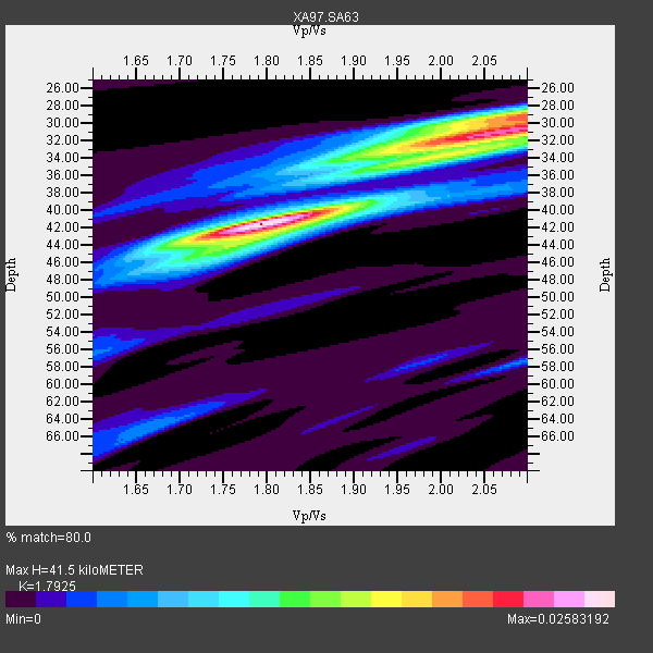
| Thickness Estimate: | 42 km |
| Thickness StdDev: | 4.8 km |
| Vp/Vs Estimate: | 1.79 |
| Vp/Vs StdDev: | 0.12 |
| Vs Estimate: | 3.604 km/s |
| Poisson's Ratio: | 0.27 |
| Peak Value: | 0.03 |
| Assumed Vp: | 6.459 km/s |
| Ps Weight: | 0.33333334 |
| PpPs Weight: | 0.33333334 |
| PsPs Weight: | 0.33333328 |
| Residual Complexity: | 0.708 |
| Nearby stations H: | +- |
| (2.0 deg) Vp/Vs: | +- |
6 with match > 90% ( 33.333332 %) and 8 with match > 80% ( 44.444443 %) out of 18.
Download stack as xyz text file.
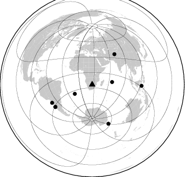
Azimuth Distribution of Events:
Prior Results for this Station
| Study | Thickness | Vp/Vs | Vp | Vs | Poissons Ratio | Extra |
| EARS | 42 km | 1.79 | 6.459 km/s | 3.604 km/s | 0.27 | |
| Crust2.0 | 37 km | 1.76 | 6.459 km/s | 3.665 km/s | 0.26 | G1,Archean, no seds. |
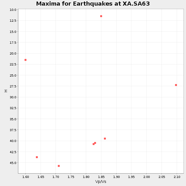
| Global Maxima | 42 km | 1.79 | 6.459 km/s | 3.604 km/s | 0.27 | amp=0.02583192 |
| Local Maxima 1 | 31 km | 2.06 | 6.459 km/s | 3.136 km/s | 0.35 | amp=0.021806763 |
| Local Maxima 2 | 29 km | 2.10 | 6.459 km/s | 3.08 km/s | 0.35 | amp=0.014754685 |
| Local Maxima 3 | 32 km | 2.09 | 6.459 km/s | 3.091 km/s | 0.35 | amp=0.008721497 |
| Local Maxima 4 | 45 km | 1.73 | 6.459 km/s | 3.739 km/s | 0.25 | amp=0.0077778073 |
| Predicted Arrivals for vertical incidence (zero ray parameter) | |
| Ps | 5.09 SECOND |
| PpPs | 17.94 SECOND |
| PsPs/PpSs | 23.03 SECOND |
Events Processed for this Station
Download zip of receiver functions as SAC
Plot maxima for each earthquake.
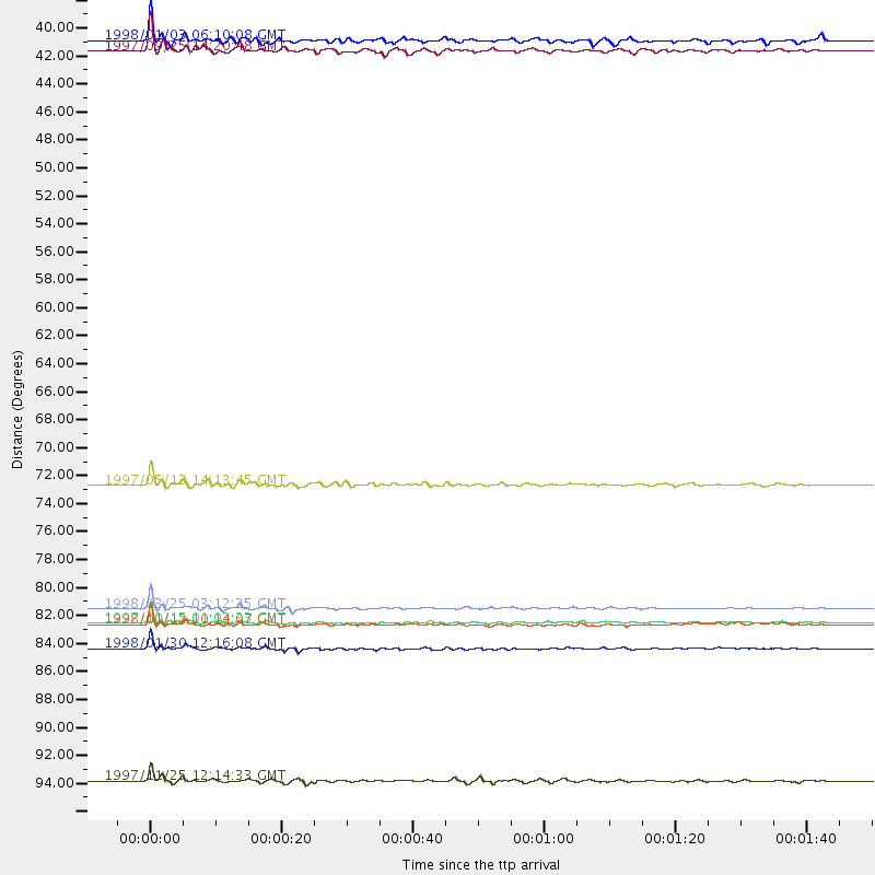
Events Used in the Stack
(8 events)| Radial Match | Distance | Baz | FERegion | Time | Lat/Lon | Depth | Magnitude |
| 98.71344 | 82.9 deg | 157.334 deg | Balleny Islands Region | 1998/03/25 03:12:25 GMT | (-62.9, 149.5) | 10 km | 6.6 MB, 8.0 MS, 8.3 UNKNOWN, 8.1 MW |
| 98.10543 | 84.0 deg | 238.977 deg | Near Coast Of Central Chile | 1997/10/15 01:03:33 GMT | (-30.9, -71.2) | 58 km | 6.8 MB, 6.8 MS, 7.3 UNKNOWN, 7.1 MW |
| 96.0336 | 86.0 deg | 245.759 deg | Near Coast Of Northern Chile | 1998/01/30 12:16:08 GMT | (-23.9, -70.2) | 42 km | 6.3 MB, 6.5 MS, 7.0 UNKNOWN, 6.7 ME |
| 93.15822 | 39.2 deg | 82.766 deg | Mid-Indian Ridge | 1997/09/25 14:20:48 GMT | (-13.8, 66.2) | 10 km | 5.3 MB, 5.7 MS, 6.0 UNKNOWN, 6.0 MW |
| 90.76153 | 84.2 deg | 238.863 deg | Near Coast Of Central Chile | 1998/01/12 10:14:07 GMT | (-31.0, -71.4) | 35 km | 5.8 MB, 6.2 MS, 6.6 UNKNOWN, 6.2 ME |
| 90.6541 | 73.2 deg | 36.463 deg | Hindu Kush Region, Afghanistan | 1997/05/13 14:13:45 GMT | (36.4, 70.9) | 196 km | 6.1 MB, 6.5 UNKNOWN, 6.4 MW |
| 85.5808 | 96.4 deg | 91.448 deg | Minahassa Peninsula, Sulawesi | 1997/11/25 12:14:33 GMT | (1.2, 122.5) | 24 km | 6.1 MB, 6.8 MS, 7.1 UNKNOWN, 6.7 ME |
| 83.61872 | 38.3 deg | 242.258 deg | Southern Mid-Atlantic Ridge | 1998/01/03 06:10:08 GMT | (-35.5, -16.2) | 10 km | 5.9 MS, 5.4 MB, 6.3 UNKNOWN, 6.1 MW |
Losers
(10 events)| Radial Match | Distance | Baz | FERegion | Time | Lat/Lon | Depth | Magnitude | Reason |
| 78.8866 | 52.5 deg | 211.643 deg | South Sandwich Islands Region | 1997/10/05 18:04:30 GMT | (-59.7, -29.2) | 274 km | 6.0 MB, 6.3 UNKNOWN, 6.3 MW | |
| 77.22258 | 61.1 deg | 355.077 deg | Ionian Sea | 1997/11/18 13:07:41 GMT | (37.6, 20.7) | 33 km | 5.9 MB, 6.4 MS, 6.7 UNKNOWN, 6.1 ML | |
| 73.97008 | 84.9 deg | 239.546 deg | Near Coast Of Central Chile | 1997/07/06 09:54:00 GMT | (-30.1, -71.9) | 19 km | 5.8 MB, 6.5 MS, 6.8 UNKNOWN, 6.4 ME | |
| 66.841805 | 85.1 deg | 240.323 deg | Near Coast Of Central Chile | 1997/07/19 12:22:57 GMT | (-29.3, -71.7) | 26 km | 5.8 MB, 5.5 MS, 5.9 UNKNOWN, 5.8 MW | |
| 62.930622 | 84.2 deg | 243.045 deg | Northern Chile | 1997/05/17 02:10:18 GMT | (-27.2, -69.5) | 106 km | 5.5 MB, 5.6 UNKNOWN, 5.5 MW | |
| 62.082333 | 83.1 deg | 248.04 deg | Jujuy Province, Argentina | 1997/07/20 10:14:22 GMT | (-23.0, -66.3) | 256 km | 5.7 MB, 6.1 UNKNOWN, 5.7 ME | |
| 61.121334 | 88.9 deg | 255.56 deg | Peru-Bolivia Border Region | 1997/11/28 22:53:41 GMT | (-13.7, -68.8) | 586 km | 6.4 MB, 6.6 UNKNOWN, 6.6 MW | |
| 56.76607 | 85.2 deg | 247.788 deg | Northern Chile | 1997/09/28 23:13:13 GMT | (-22.4, -68.4) | 107 km | 5.7 MB, 5.6 UNKNOWN, 5.6 MW | |
| 50.74993 | 83.9 deg | 59.058 deg | Myanmar | 1997/12/30 13:43:18 GMT | (25.4, 96.6) | 33 km | 5.7 MS, 5.4 MB, 5.7 UNKNOWN, 5.7 MW | |
| 50.49462 | 82.9 deg | 93.11 deg | Java Sea | 1997/07/11 09:55:12 GMT | (-5.7, 110.8) | 574 km | 5.6 MB |
