
Station XA SA68 - XA.SA68
Network: XA97 - Anatomy of an Archean Craton, South Africa
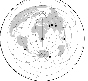
Nearby stations (2 deg radius)
| Station | Name | (Lat, Lon) | Start / End | Elevation |
| SA68 | XA.SA68 | (-21.95, 28.19) | 1997-04-30 / 1999-12-31 | 737 m |
| Crust2 Type: | G1,Archean, no seds. |
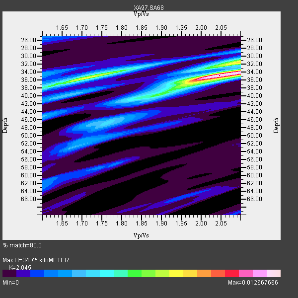
| Thickness Estimate: | 35 km |
| Thickness StdDev: | 4.1 km |
| Vp/Vs Estimate: | 2.05 |
| Vp/Vs StdDev: | 0.14 |
| Vs Estimate: | 3.159 km/s |
| Poisson's Ratio: | 0.34 |
| Peak Value: | 0.01 |
| Assumed Vp: | 6.459 km/s |
| Ps Weight: | 0.33333334 |
| PpPs Weight: | 0.33333334 |
| PsPs Weight: | 0.33333328 |
| Residual Complexity: | 0.652 |
| Nearby stations H: | +- |
| (2.0 deg) Vp/Vs: | +- |
7 with match > 90% ( 31.818182 %) and 8 with match > 80% ( 36.363636 %) out of 22.
Download stack as xyz text file.
Azimuth Distribution of Events:
Prior Results for this Station
| Study | Thickness | Vp/Vs | Vp | Vs | Poissons Ratio | Extra |
| EARS | 35 km | 2.05 | 6.459 km/s | 3.159 km/s | 0.34 | |
| Crust2.0 | 37 km | 1.76 | 6.459 km/s | 3.665 km/s | 0.26 | G1,Archean, no seds. |
| Global Maxima | 35 km | 2.05 | 6.459 km/s | 3.159 km/s | 0.34 | amp=0.012667666 |
| Local Maxima 1 | 35 km | 1.72 | 6.459 km/s | 3.766 km/s | 0.24 | amp=0.007720175 |
| Local Maxima 2 | 32 km | 2.08 | 6.459 km/s | 3.106 km/s | 0.35 | amp=0.004969789 |
| Local Maxima 3 | 40 km | 1.84 | 6.459 km/s | 3.511 km/s | 0.29 | amp=0.004077464 |
| Local Maxima 4 | 52 km | 1.69 | 6.459 km/s | 3.822 km/s | 0.23 | amp=0.0030507953 |
| Predicted Arrivals for vertical incidence (zero ray parameter) | |
| Ps | 5.62 SECOND |
| PpPs | 16.38 SECOND |
| PsPs/PpSs | 22.00 SECOND |
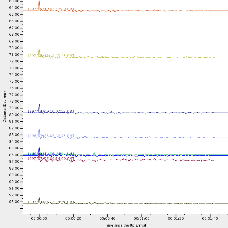
Events Processed for this Station
Download zip of receiver functions as SAC
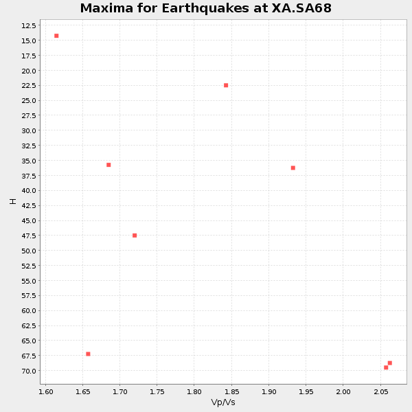
Plot maxima for each earthquake.
Events Used in the Stack
(8 events)| Radial Match | Distance | Baz | FERegion | Time | Lat/Lon | Depth | Magnitude |
| 98.44245 | 83.7 deg | 156.808 deg | Balleny Islands Region | 1998/03/25 03:12:25 GMT | (-62.9, 149.5) | 10 km | 6.6 MB, 8.0 MS, 8.3 UNKNOWN, 8.1 MW |
| 97.51142 | 86.6 deg | 238.129 deg | Near Coast Of Central Chile | 1997/10/15 01:03:33 GMT | (-30.9, -71.2) | 58 km | 6.8 MB, 6.8 MS, 7.3 UNKNOWN, 7.1 MW |
| 96.93946 | 63.1 deg | 29.298 deg | Northern And Central Iran | 1997/05/10 07:57:29 GMT | (33.8, 59.8) | 10 km | 6.4 MB, 7.3 MS, 7.5 UNKNOWN, 7.2 MW |
| 95.897675 | 79.7 deg | 45.689 deg | Xizang | 1997/11/08 10:02:52 GMT | (35.1, 87.3) | 33 km | 6.2 MB, 7.9 MS, 7.7 UNKNOWN, 7.6 MW |
| 94.20639 | 70.7 deg | 35.464 deg | Hindu Kush Region, Afghanistan | 1997/05/13 14:13:45 GMT | (36.4, 70.9) | 196 km | 6.1 MB, 6.5 UNKNOWN, 6.4 MW |
| 90.405594 | 86.7 deg | 238.017 deg | Near Coast Of Central Chile | 1998/01/12 10:14:07 GMT | (-31.0, -71.4) | 35 km | 5.8 MB, 6.2 MS, 6.6 UNKNOWN, 6.2 ME |
| 90.09224 | 94.5 deg | 90.471 deg | Minahassa Peninsula, Sulawesi | 1997/11/25 12:14:33 GMT | (1.2, 122.5) | 24 km | 6.1 MB, 6.8 MS, 7.1 UNKNOWN, 6.7 ME |
| 80.59123 | 87.4 deg | 238.704 deg | Near Coast Of Central Chile | 1997/07/06 09:54:00 GMT | (-30.1, -71.9) | 19 km | 5.8 MB, 6.5 MS, 6.8 UNKNOWN, 6.4 ME |
Losers
(14 events)| Radial Match | Distance | Baz | FERegion | Time | Lat/Lon | Depth | Magnitude | Reason |
| 94.132385 | 70.6 deg | 35.372 deg | Hindu Kush Region, Afghanistan | 1997/12/17 05:51:29 GMT | (36.4, 70.8) | 207 km | 5.5 MB, 6.3 UNKNOWN | |
| 78.285446 | 55.0 deg | 211.394 deg | South Sandwich Islands Region | 1997/10/05 18:04:30 GMT | (-59.7, -29.2) | 274 km | 6.0 MB, 6.3 UNKNOWN, 6.3 MW | |
| 75.05663 | 37.1 deg | 83.817 deg | Mid-Indian Ridge | 1997/09/25 14:20:48 GMT | (-13.8, 66.2) | 10 km | 5.3 MB, 5.7 MS, 6.0 UNKNOWN, 6.0 MW | |
| 73.07884 | 81.1 deg | 92.551 deg | Java Sea | 1997/07/11 09:55:12 GMT | (-5.7, 110.8) | 574 km | 5.6 MB | |
| 71.7816 | 85.6 deg | 247.146 deg | Jujuy Province, Argentina | 1997/07/20 10:14:22 GMT | (-23.0, -66.3) | 256 km | 5.7 MB, 6.1 UNKNOWN, 5.7 ME | |
| 71.745705 | 79.0 deg | 319.065 deg | Azores Islands, Portugal | 1997/06/27 04:39:52 GMT | (38.3, -26.7) | 10 km | 5.6 MB, 5.4 MS, 5.9 UNKNOWN, 5.9 MW | |
| 66.96791 | 86.3 deg | 152.028 deg | West Of Macquarie Island | 1997/10/17 09:55:15 GMT | (-57.5, 148.0) | 10 km | 5.2 MB, 5.9 MS, 6.2 UNKNOWN, 6.0 MW | |
| 66.49456 | 47.6 deg | 126.981 deg | Mid-Indian Ridge | 1997/08/20 13:51:16 GMT | (-41.7, 80.1) | 10 km | 5.6 MB, 6.4 MS, 6.5 UNKNOWN, 6.4 MW | |
| 64.214874 | 86.7 deg | 242.184 deg | Northern Chile | 1997/05/17 02:10:18 GMT | (-27.2, -69.5) | 106 km | 5.5 MB, 5.6 UNKNOWN, 5.5 MW | |
| 56.63712 | 43.5 deg | 68.623 deg | Carlsberg Ridge | 1998/01/14 18:53:14 GMT | (-2.1, 68.1) | 10 km | 5.6 MS, 5.3 MB | |
| 53.384583 | 71.4 deg | 81.019 deg | Northern Sumatra, Indonesia | 1997/07/07 11:24:37 GMT | (1.1, 97.6) | 29 km | 5.7 MS, 5.4 MB, 5.9 UNKNOWN, 5.8 MW | |
| 52.83681 | 87.6 deg | 239.479 deg | Near Coast Of Central Chile | 1997/07/19 12:22:57 GMT | (-29.3, -71.7) | 26 km | 5.8 MB, 5.5 MS, 5.9 UNKNOWN, 5.8 MW | |
| 52.586628 | 91.3 deg | 254.75 deg | Peru-Bolivia Border Region | 1997/11/28 22:53:41 GMT | (-13.7, -68.8) | 586 km | 6.4 MB, 6.6 UNKNOWN, 6.6 MW | |
| 45.94251 | 88.4 deg | 248.95 deg | Chile-Bolivia Border Region | 1997/12/09 14:23:45 GMT | (-20.2, -68.4) | 133 km | 5.7 MB, 5.7 UNKNOWN, 5.7 MW |
