
Station XA SA74 - XA.SA74
Network: XA97 - Anatomy of an Archean Craton, South Africa
Nearby stations (2 deg radius)
| Station | Name | (Lat, Lon) | Start / End | Elevation |
| SA74 | XA.SA74 | (-21.92, 30.94) | 1997-04-14 / 1999-12-31 | 487 m |
| Crust2 Type: | I1,late Proter., no seds. |
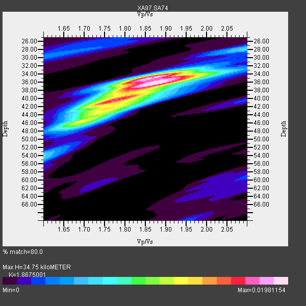
| Thickness Estimate: | 35 km |
| Thickness StdDev: | 3.0 km |
| Vp/Vs Estimate: | 1.87 |
| Vp/Vs StdDev: | 0.06 |
| Vs Estimate: | 3.557 km/s |
| Poisson's Ratio: | 0.30 |
| Peak Value: | 0.02 |
| Assumed Vp: | 6.642 km/s |
| Ps Weight: | 0.33333334 |
| PpPs Weight: | 0.33333334 |
| PsPs Weight: | 0.33333328 |
| Residual Complexity: | 0.701 |
| Nearby stations H: | +- |
| (2.0 deg) Vp/Vs: | +- |
8 with match > 90% ( 32.0 %) and 11 with match > 80% ( 44.0 %) out of 25.
Download stack as xyz text file.
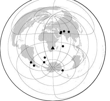
Azimuth Distribution of Events:
Prior Results for this Station
| Study | Thickness | Vp/Vs | Vp | Vs | Poissons Ratio | Extra |
| EARS | 35 km | 1.87 | 6.642 km/s | 3.557 km/s | 0.30 | |
| Crust2.0 | 43 km | 1.77 | 6.642 km/s | 3.756 km/s | 0.26 | I1,late Proter., no seds. |
| Global Maxima | 35 km | 1.87 | 6.642 km/s | 3.557 km/s | 0.30 | amp=0.01981154 |
| Local Maxima 1 | 36 km | 1.88 | 6.642 km/s | 3.542 km/s | 0.30 | amp=0.015353017 |
| Local Maxima 2 | 40 km | 1.78 | 6.642 km/s | 3.731 km/s | 0.27 | amp=0.010632589 |
| Local Maxima 3 | 46 km | 1.68 | 6.642 km/s | 3.948 km/s | 0.23 | amp=0.0072269607 |
| Local Maxima 4 | 42 km | 1.81 | 6.642 km/s | 3.68 km/s | 0.28 | amp=0.0066288314 |
| Predicted Arrivals for vertical incidence (zero ray parameter) | |
| Ps | 4.54 SECOND |
| PpPs | 15.00 SECOND |
| PsPs/PpSs | 19.54 SECOND |
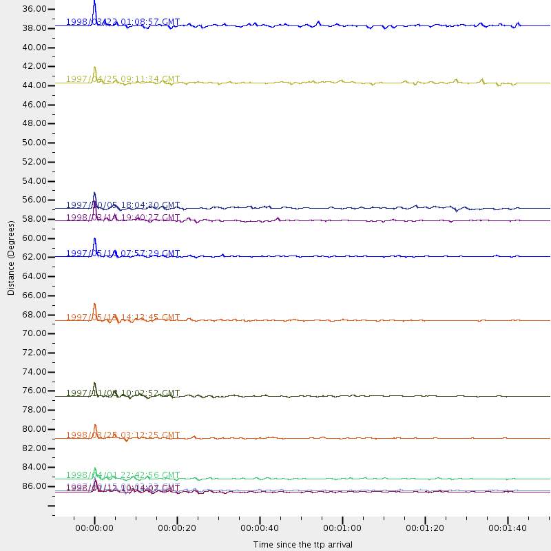
Events Processed for this Station
Download zip of receiver functions as SAC
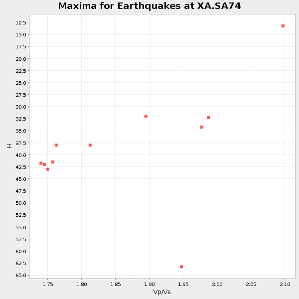
Plot maxima for each earthquake.
Events Used in the Stack
(11 events)| Radial Match | Distance | Baz | FERegion | Time | Lat/Lon | Depth | Magnitude |
| 98.85164 | 82.7 deg | 156.066 deg | Balleny Islands Region | 1998/03/25 03:12:25 GMT | (-62.9, 149.5) | 10 km | 6.6 MB, 8.0 MS, 8.3 UNKNOWN, 8.1 MW |
| 98.392006 | 61.9 deg | 27.113 deg | Northern And Central Iran | 1997/05/10 07:57:29 GMT | (33.8, 59.8) | 10 km | 6.4 MB, 7.3 MS, 7.5 UNKNOWN, 7.2 MW |
| 97.35974 | 88.7 deg | 237.163 deg | Near Coast Of Central Chile | 1997/10/15 01:03:33 GMT | (-30.9, -71.2) | 58 km | 6.8 MB, 6.8 MS, 7.3 UNKNOWN, 7.1 MW |
| 95.79123 | 87.4 deg | 227.432 deg | Off Coast Of Southern Chile | 1998/04/01 22:42:56 GMT | (-40.3, -74.9) | 9.0 km | 6.2 MB, 6.0 MS, 6.7 UNKNOWN, 6.6 ME |
| 95.342155 | 77.9 deg | 44.315 deg | Xizang | 1997/11/08 10:02:52 GMT | (35.1, 87.3) | 33 km | 6.2 MB, 7.9 MS, 7.7 UNKNOWN, 7.6 MW |
| 95.25242 | 69.2 deg | 33.684 deg | Hindu Kush Region, Afghanistan | 1997/05/13 14:13:45 GMT | (36.4, 70.9) | 196 km | 6.1 MB, 6.5 UNKNOWN, 6.4 MW |
| 94.39621 | 88.9 deg | 237.048 deg | Near Coast Of Central Chile | 1998/01/12 10:14:07 GMT | (-31.0, -71.4) | 35 km | 5.8 MB, 6.2 MS, 6.6 UNKNOWN, 6.2 ME |
| 91.313126 | 57.8 deg | 27.356 deg | Northern And Central Iran | 1998/03/14 19:40:27 GMT | (30.2, 57.6) | 9.0 km | 5.9 MB, 6.9 MS, 6.6 UNKNOWN, 6.3 ME |
| 87.75521 | 35.3 deg | 78.61 deg | Mid-Indian Ridge | 1998/03/22 01:08:57 GMT | (-11.4, 66.2) | 10 km | 5.4 MB, 6.1 MS, 6.1 UNKNOWN, 6.1 MW |
| 86.4154 | 56.3 deg | 211.848 deg | South Sandwich Islands Region | 1997/10/05 18:04:30 GMT | (-59.7, -29.2) | 274 km | 6.0 MB, 6.3 UNKNOWN, 6.3 MW |
| 86.130875 | 41.9 deg | 220.92 deg | Southern Mid-Atlantic Ridge | 1997/04/25 09:11:34 GMT | (-48.3, -10.0) | 10 km | 5.8 MS, 5.3 MB, 5.8 UNKNOWN, 5.7 MW |
Losers
(14 events)| Radial Match | Distance | Baz | FERegion | Time | Lat/Lon | Depth | Magnitude | Reason |
| 94.65568 | 69.1 deg | 33.586 deg | Hindu Kush Region, Afghanistan | 1997/12/17 05:51:29 GMT | (36.4, 70.8) | 207 km | 5.5 MB, 6.3 UNKNOWN | |
| 85.31436 | 89.6 deg | 237.717 deg | Near Coast Of Central Chile | 1997/07/06 09:54:00 GMT | (-30.1, -71.9) | 19 km | 5.8 MB, 6.5 MS, 6.8 UNKNOWN, 6.4 ME | |
| 80.071655 | 89.8 deg | 238.488 deg | Near Coast Of Central Chile | 1997/07/19 12:22:57 GMT | (-29.3, -71.7) | 26 km | 5.8 MB, 5.5 MS, 5.9 UNKNOWN, 5.8 MW | |
| 77.788445 | 43.1 deg | 241.092 deg | Southern Mid-Atlantic Ridge | 1998/01/03 06:10:08 GMT | (-35.5, -16.2) | 10 km | 5.9 MS, 5.4 MB, 6.3 UNKNOWN, 6.1 MW | |
| 75.16144 | 98.0 deg | 82.691 deg | Mindanao, Philippines | 1997/10/06 12:30:05 GMT | (9.8, 125.8) | 106 km | 5.9 MB, 6.5 UNKNOWN, 6.4 MW | |
| 75.0535 | 34.5 deg | 82.41 deg | Mid-Indian Ridge | 1997/09/25 14:20:48 GMT | (-13.8, 66.2) | 10 km | 5.3 MB, 5.7 MS, 6.0 UNKNOWN, 6.0 MW | |
| 74.097946 | 85.1 deg | 151.176 deg | West Of Macquarie Island | 1997/10/17 09:55:15 GMT | (-57.5, 148.0) | 10 km | 5.2 MB, 5.9 MS, 6.2 UNKNOWN, 6.0 MW | |
| 70.70559 | 65.5 deg | 49.919 deg | Southern India | 1997/05/21 22:51:28 GMT | (23.1, 80.0) | 36 km | 6.0 MB, 5.6 MS, 5.8 UNKNOWN, 5.6 ME | |
| 70.54367 | 69.2 deg | 76.184 deg | Northern Sumatra, Indonesia | 1997/08/20 07:15:15 GMT | (4.4, 96.5) | 33 km | 5.9 MB, 6.0 MS, 6.1 UNKNOWN, 6.0 MW | |
| 67.63245 | 78.5 deg | 91.551 deg | Java Sea | 1997/07/11 09:55:12 GMT | (-5.7, 110.8) | 574 km | 5.6 MB | |
| 64.80077 | 93.7 deg | 253.7 deg | Peru-Bolivia Border Region | 1997/11/28 22:53:41 GMT | (-13.7, -68.8) | 586 km | 6.4 MB, 6.6 UNKNOWN, 6.6 MW | |
| 53.08849 | 52.2 deg | 287.697 deg | North Of Ascension Island | 1998/03/29 07:14:58 GMT | (-0.2, -17.9) | 10 km | 5.5 MB, 5.6 MS, 6.1 UNKNOWN, 6.1 MW | |
| 52.910915 | 80.7 deg | 317.7 deg | Azores Islands, Portugal | 1997/06/27 04:39:52 GMT | (38.3, -26.7) | 10 km | 5.6 MB, 5.4 MS, 5.9 UNKNOWN, 5.9 MW | |
| 40.73308 | 95.9 deg | 97.186 deg | Banda Sea | 1998/02/19 14:14:51 GMT | (-4.5, 129.1) | 33 km | 6.1 MB, 6.4 MS, 6.5 UNKNOWN, 6.5 MW |
