
Station XA SA80 - XA.SA80
Network: XA97 - Anatomy of an Archean Craton, South Africa
Nearby stations (2 deg radius)
| Station | Name | (Lat, Lon) | Start / End | Elevation |
| SA80 | XA.SA80 | (-19.96, 31.32) | 1997-04-10 / 1999-12-31 | 1064 m |
| Crust2 Type: | I1,late Proter., no seds. |
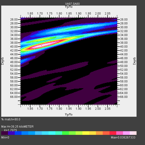
| Thickness Estimate: | 39 km |
| Thickness StdDev: | 2.9 km |
| Vp/Vs Estimate: | 1.71 |
| Vp/Vs StdDev: | 0.07 |
| Vs Estimate: | 3.89 km/s |
| Poisson's Ratio: | 0.24 |
| Peak Value: | 0.04 |
| Assumed Vp: | 6.642 km/s |
| Ps Weight: | 0.33333334 |
| PpPs Weight: | 0.33333334 |
| PsPs Weight: | 0.33333328 |
| Residual Complexity: | 0.590 |
| Nearby stations H: | +- |
| (2.0 deg) Vp/Vs: | +- |
4 with match > 90% ( 18.181818 %) and 7 with match > 80% ( 31.818182 %) out of 22.
Download stack as xyz text file.
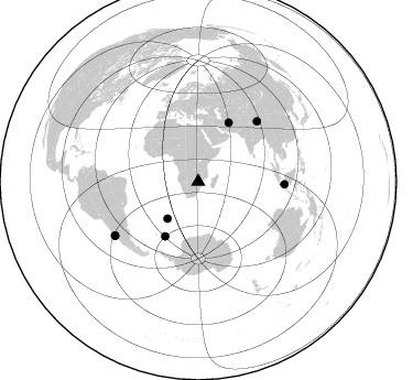
Azimuth Distribution of Events:
Prior Results for this Station
| Study | Thickness | Vp/Vs | Vp | Vs | Poissons Ratio | Extra |
| EARS | 39 km | 1.71 | 6.642 km/s | 3.89 km/s | 0.24 | |
| Crust2.0 | 43 km | 1.77 | 6.642 km/s | 3.756 km/s | 0.26 | I1,late Proter., no seds. |
| Global Maxima | 39 km | 1.71 | 6.642 km/s | 3.89 km/s | 0.24 | amp=0.038267333 |
| Local Maxima 1 | 36 km | 1.82 | 6.642 km/s | 3.659 km/s | 0.28 | amp=0.023469515 |
| Local Maxima 2 | 36 km | 1.69 | 6.642 km/s | 3.936 km/s | 0.23 | amp=0.01805357 |
| Local Maxima 3 | 30 km | 1.90 | 6.642 km/s | 3.487 km/s | 0.31 | amp=0.015370812 |
| Local Maxima 4 | 41 km | 1.66 | 6.642 km/s | 3.989 km/s | 0.22 | amp=0.011289674 |
| Predicted Arrivals for vertical incidence (zero ray parameter) | |
| Ps | 4.18 SECOND |
| PpPs | 16.00 SECOND |
| PsPs/PpSs | 20.18 SECOND |
Events Processed for this Station
Download zip of receiver functions as SAC
Plot maxima for each earthquake.
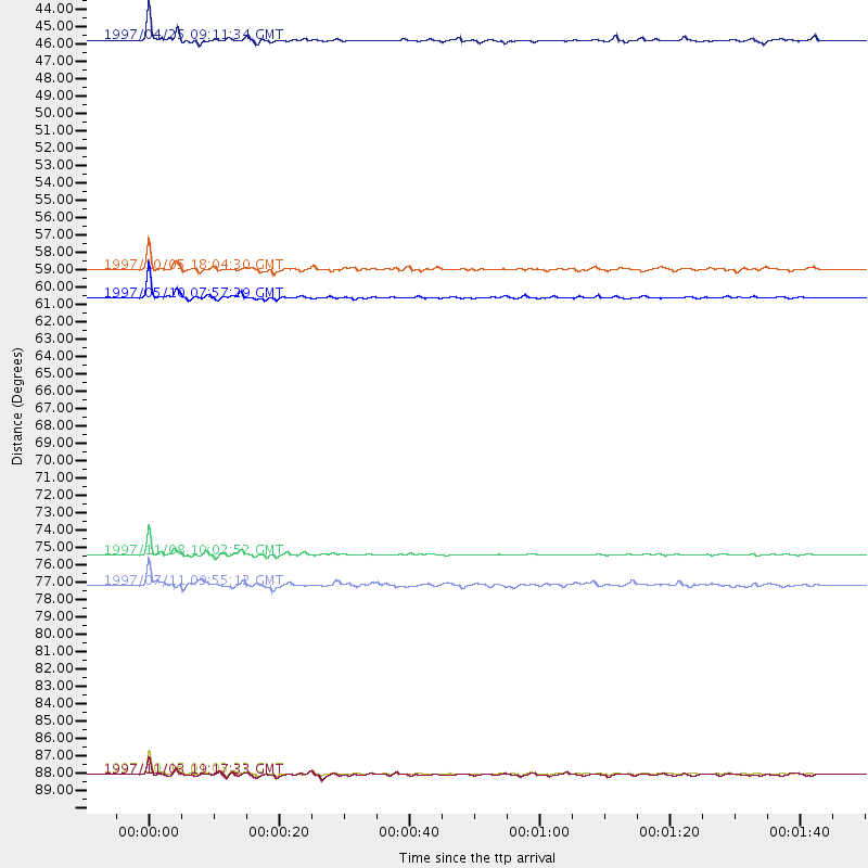
Events Used in the Stack
(7 events)| Radial Match | Distance | Baz | FERegion | Time | Lat/Lon | Depth | Magnitude |
| 98.56308 | 90.1 deg | 237.013 deg | Near Coast Of Central Chile | 1997/10/15 01:03:33 GMT | (-30.9, -71.2) | 58 km | 6.8 MB, 6.8 MS, 7.3 UNKNOWN, 7.1 MW |
| 97.913605 | 60.0 deg | 27.297 deg | Northern And Central Iran | 1997/05/10 07:57:29 GMT | (33.8, 59.8) | 10 km | 6.4 MB, 7.3 MS, 7.5 UNKNOWN, 7.2 MW |
| 97.80062 | 76.3 deg | 44.434 deg | Xizang | 1997/11/08 10:02:52 GMT | (35.1, 87.3) | 33 km | 6.2 MB, 7.9 MS, 7.7 UNKNOWN, 7.6 MW |
| 92.366066 | 43.6 deg | 219.712 deg | Southern Mid-Atlantic Ridge | 1997/04/25 09:11:34 GMT | (-48.3, -10.0) | 10 km | 5.8 MS, 5.3 MB, 5.8 UNKNOWN, 5.7 MW |
| 86.98056 | 58.2 deg | 211.251 deg | South Sandwich Islands Region | 1997/10/05 18:04:30 GMT | (-59.7, -29.2) | 274 km | 6.0 MB, 6.3 UNKNOWN, 6.3 MW |
| 81.64049 | 78.2 deg | 91.82 deg | Java Sea | 1997/07/11 09:55:12 GMT | (-5.7, 110.8) | 574 km | 5.6 MB |
| 80.70121 | 90.2 deg | 237.185 deg | Near Coast Of Central Chile | 1997/11/03 19:17:33 GMT | (-30.7, -71.2) | 45 km | 6.2 MB, 5.6 MS, 6.3 UNKNOWN, 5.8 MD |
Losers
(15 events)| Radial Match | Distance | Baz | FERegion | Time | Lat/Lon | Depth | Magnitude | Reason |
| 79.691025 | 74.2 deg | 55.6 deg | India-Bangladesh Border Region | 1997/05/08 02:53:14 GMT | (24.9, 92.2) | 35 km | 5.6 MB, 5.6 MS, 6.0 UNKNOWN, 5.9 MW | |
| 78.74566 | 33.9 deg | 85.072 deg | Mid-Indian Ridge | 1997/09/25 14:20:48 GMT | (-13.8, 66.2) | 10 km | 5.3 MB, 5.7 MS, 6.0 UNKNOWN, 6.0 MW | |
| 77.54322 | 72.9 deg | 35.332 deg | Southern Xinjiang, China | 1997/04/11 05:34:42 GMT | (39.5, 76.9) | 15 km | 5.8 MB, 6.1 MS, 6.1 UNKNOWN, 5.8 ME | |
| 76.14667 | 79.5 deg | 317.287 deg | Azores Islands, Portugal | 1997/06/27 04:39:52 GMT | (38.3, -26.7) | 10 km | 5.6 MB, 5.4 MS, 5.9 UNKNOWN, 5.9 MW | |
| 74.89941 | 95.8 deg | 279.679 deg | Windward Islands | 1997/04/22 09:31:23 GMT | (11.1, -60.9) | 5.0 km | 6.0 MB, 6.5 MS, 6.7 UNKNOWN, 6.1 ME | |
| 74.01767 | 46.5 deg | 129.002 deg | Mid-Indian Ridge | 1997/08/20 13:51:16 GMT | (-41.7, 80.1) | 10 km | 5.6 MB, 6.4 MS, 6.5 UNKNOWN, 6.4 MW | |
| 69.57427 | 58.1 deg | 350.028 deg | Ionian Sea | 1997/11/18 13:07:41 GMT | (37.6, 20.7) | 33 km | 5.9 MB, 6.4 MS, 6.7 UNKNOWN, 6.1 ML | |
| 68.47244 | 90.8 deg | 237.173 deg | Near Coast Of Central Chile | 1997/07/27 05:21:29 GMT | (-30.5, -71.9) | 33 km | 5.6 MB, 5.8 MS, 6.3 UNKNOWN, 6.2 MW | |
| 66.94621 | 55.8 deg | 212.834 deg | South Sandwich Islands Region | 1997/06/02 21:24:38 GMT | (-57.8, -25.5) | 33 km | 5.9 MB, 5.8 MS, 6.1 UNKNOWN, 6.1 MW | |
| 64.507225 | 93.7 deg | 80.583 deg | Panay, Philippines | 1997/05/12 13:45:26 GMT | (10.2, 121.7) | 33 km | 5.5 MB, 5.8 MS, 6.1 UNKNOWN, 5.9 MW | |
| 55.933926 | 96.7 deg | 99.517 deg | Banda Sea | 1997/07/31 21:54:21 GMT | (-6.6, 130.9) | 59 km | 5.9 MB, 5.3 MS, 6.1 UNKNOWN, 6.1 MW | |
| 54.223724 | 73.0 deg | 35.283 deg | Southern Xinjiang, China | 1997/04/15 18:19:10 GMT | (39.6, 77.0) | 23 km | 5.8 MS, 5.4 MB, 5.9 UNKNOWN, 5.7 MW | |
| 48.87764 | 70.8 deg | 86.581 deg | Southern Sumatra, Indonesia | 1997/04/22 05:55:59 GMT | (-3.4, 102.1) | 108 km | 5.6 MB, 5.9 UNKNOWN, 5.9 MW | |
| 46.10586 | 95.8 deg | 96.848 deg | Banda Sea | 1998/02/19 14:14:51 GMT | (-4.5, 129.1) | 33 km | 6.1 MB, 6.4 MS, 6.5 UNKNOWN, 6.5 MW | |
| 42.914726 | 94.6 deg | 253.693 deg | Peru-Bolivia Border Region | 1997/11/28 22:53:41 GMT | (-13.7, -68.8) | 586 km | 6.4 MB, 6.6 UNKNOWN, 6.6 MW |
