
Station XA SA82 - XA.SA82
Network: XA97 - Anatomy of an Archean Craton, South Africa
Nearby stations (2 deg radius)
| Station | Name | (Lat, Lon) | Start / End | Elevation |
| SA82 | XA.SA82 | (-30.98, 22.25) | 1997-04-20 / 1999-12-31 | 1452 m |
| Crust2 Type: | I2,late Proter., 1 km seds. |
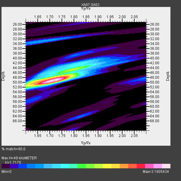
| Thickness Estimate: | 49 km |
| Thickness StdDev: | 1.6 km |
| Vp/Vs Estimate: | 1.72 |
| Vp/Vs StdDev: | 0.05 |
| Vs Estimate: | 3.829 km/s |
| Poisson's Ratio: | 0.24 |
| Peak Value: | 3.19 |
| Assumed Vp: | 6.576 km/s |
| Ps Weight: | 0.33333334 |
| PpPs Weight: | 0.33333334 |
| PsPs Weight: | 0.33333328 |
| Residual Complexity: | 0.554 |
| Nearby stations H: | +- |
| (2.0 deg) Vp/Vs: | +- |
4 with match > 90% ( 19.047619 %) and 7 with match > 80% ( 33.333332 %) out of 21.
Download stack as xyz text file.
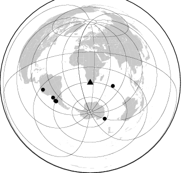
Azimuth Distribution of Events:
Prior Results for this Station
| Study | Thickness | Vp/Vs | Vp | Vs | Poissons Ratio | Extra |
| EARS | 49 km | 1.72 | 6.576 km/s | 3.829 km/s | 0.24 | |
| Crust2.0 | 38 km | 1.78 | 6.576 km/s | 3.695 km/s | 0.27 | I2,late Proter., 1 km seds. |
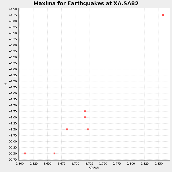
| Global Maxima | 49 km | 1.72 | 6.576 km/s | 3.829 km/s | 0.24 | amp=3.1905434 |
| Local Maxima 1 | 49 km | 1.64 | 6.576 km/s | 4.004 km/s | 0.21 | amp=1.6459917 |
| Local Maxima 2 | 44 km | 1.82 | 6.576 km/s | 3.613 km/s | 0.28 | amp=1.4557599 |
| Local Maxima 3 | 33 km | 1.67 | 6.576 km/s | 3.932 km/s | 0.22 | amp=0.7087937 |
| Local Maxima 4 | 52 km | 1.61 | 6.576 km/s | 4.091 km/s | 0.18 | amp=0.65987056 |
| Predicted Arrivals for vertical incidence (zero ray parameter) | |
| Ps | 5.35 SECOND |
| PpPs | 20.25 SECOND |
| PsPs/PpSs | 25.59 SECOND |
Events Processed for this Station
Download zip of receiver functions as SAC
Plot maxima for each earthquake.
Events Used in the Stack
(7 events)| Radial Match | Distance | Baz | FERegion | Time | Lat/Lon | Depth | Magnitude |
| 96.80121 | 77.4 deg | 241.488 deg | Near Coast Of Central Chile | 1997/10/15 01:03:33 GMT | (-30.9, -71.2) | 58 km | 6.8 MB, 6.8 MS, 7.3 UNKNOWN, 7.1 MW |
| 96.53224 | 77.5 deg | 158.064 deg | Balleny Islands Region | 1998/03/25 03:12:25 GMT | (-62.9, 149.5) | 10 km | 6.6 MB, 8.0 MS, 8.3 UNKNOWN, 8.1 MW |
| 96.35052 | 80.1 deg | 248.17 deg | Near Coast Of Northern Chile | 1998/01/30 12:16:08 GMT | (-23.9, -70.2) | 42 km | 6.3 MB, 6.5 MS, 7.0 UNKNOWN, 6.7 ME |
| 94.856735 | 45.7 deg | 97.992 deg | Mid-Indian Ridge | 1999/01/24 08:00:08 GMT | (-26.5, 74.5) | 10 km | 6.0 MB, 6.3 MS, 6.3 MW, 6.3 ME |
| 88.18799 | 77.6 deg | 241.361 deg | Near Coast Of Central Chile | 1998/01/12 10:14:07 GMT | (-31.0, -71.4) | 35 km | 5.8 MB, 6.2 MS, 6.6 UNKNOWN, 6.2 ME |
| 86.79721 | 78.5 deg | 242.601 deg | Near Coast Of Central Chile | 1998/09/03 17:37:58 GMT | (-29.5, -71.7) | 27 km | 6.2 MB, 6.6 MS, 6.5 UNKNOWN, 6.4 ME |
| 84.77597 | 95.4 deg | 261.67 deg | Northern Peru | 1997/10/28 06:15:17 GMT | (-4.4, -76.7) | 112 km | 6.6 MB, 6.3 MS, 7.2 UNKNOWN, 6.6 ME |
Losers
(14 events)| Radial Match | Distance | Baz | FERegion | Time | Lat/Lon | Depth | Magnitude | Reason |
| 78.57375 | 44.5 deg | 214.378 deg | South Sandwich Islands Region | 1997/10/05 18:04:30 GMT | (-59.7, -29.2) | 274 km | 6.0 MB, 6.3 UNKNOWN, 6.3 MW | |
| 75.920204 | 81.1 deg | 37.835 deg | Hindu Kush Region, Afghanistan | 1997/05/13 14:13:45 GMT | (36.4, 70.9) | 196 km | 6.1 MB, 6.5 UNKNOWN, 6.4 MW | |
| 74.20099 | 73.9 deg | 234.926 deg | S. Chile-Argentina Border Region | 1998/12/14 16:25:24 GMT | (-38.2, -71.0) | 138 km | 6.0 UNKNOWN, 4.8 MS, 5.4 MB | |
| 73.87396 | 76.8 deg | 240.221 deg | Near Coast Of Central Chile | 1998/07/29 07:14:24 GMT | (-32.3, -71.3) | 51 km | 6.3 MB, 6.5 UNKNOWN, 6.5 ME | |
| 69.32671 | 96.4 deg | 93.579 deg | Minahassa Peninsula, Sulawesi | 1999/02/23 07:27:56 GMT | (0.2, 119.5) | 33 km | 5.6 MB, 5.8 MS | |
| 59.859653 | 80.4 deg | 252.256 deg | Chile-Bolivia Border Region | 1997/12/09 14:23:45 GMT | (-20.2, -68.4) | 133 km | 5.7 MB, 5.7 UNKNOWN, 5.7 MW | |
| 59.844437 | 85.9 deg | 94.128 deg | Java Sea | 1997/07/11 09:55:12 GMT | (-5.7, 110.8) | 574 km | 5.6 MB | |
| 56.921238 | 77.6 deg | 77.641 deg | Northern Sumatra, Indonesia | 1999/02/04 19:28:00 GMT | (4.0, 95.3) | 56 km | 5.8 MB, 5.4 MS, 5.9 MW, 5.9 MW | |
| 56.534393 | 77.9 deg | 245.603 deg | Northern Chile | 1997/05/17 02:10:18 GMT | (-27.2, -69.5) | 106 km | 5.5 MB, 5.6 UNKNOWN, 5.5 MW | |
| 56.097633 | 74.5 deg | 238.744 deg | Chile-Argentina Border Region | 1999/03/05 03:35:14 GMT | (-34.7, -69.6) | 10 km | 5.5 MS, 5.2 MB | |
| 53.966328 | 48.8 deg | 301.006 deg | North Of Ascension Island | 1998/03/29 07:14:58 GMT | (-0.2, -17.9) | 10 km | 5.5 MB, 5.6 MS, 6.1 UNKNOWN, 6.1 MW | |
| 52.543232 | 83.9 deg | 257.708 deg | Peru-Bolivia Border Region | 1997/11/28 22:53:41 GMT | (-13.7, -68.8) | 586 km | 6.4 MB, 6.6 UNKNOWN, 6.6 MW | |
| 51.59927 | 78.6 deg | 242.765 deg | Near Coast Of Central Chile | 1997/07/19 12:22:57 GMT | (-29.3, -71.7) | 26 km | 5.8 MB, 5.5 MS, 5.9 UNKNOWN, 5.8 MW | |
| 46.79998 | 79.4 deg | 250.302 deg | Northern Chile | 1997/09/28 23:13:13 GMT | (-22.4, -68.4) | 107 km | 5.7 MB, 5.6 UNKNOWN, 5.6 MW |
