
Station XB WAG00 - XB.WAG00
Network: XB00 - Marlborough New Zealand Short-Period Arrays
Nearby stations (2 deg radius)
| Station | Name | (Lat, Lon) | Start / End | Elevation |
| WAG00 | XB.WAG00 | (-42.07, 172.93) | 2001-04-17 / 2003-01-01 | 942 m |
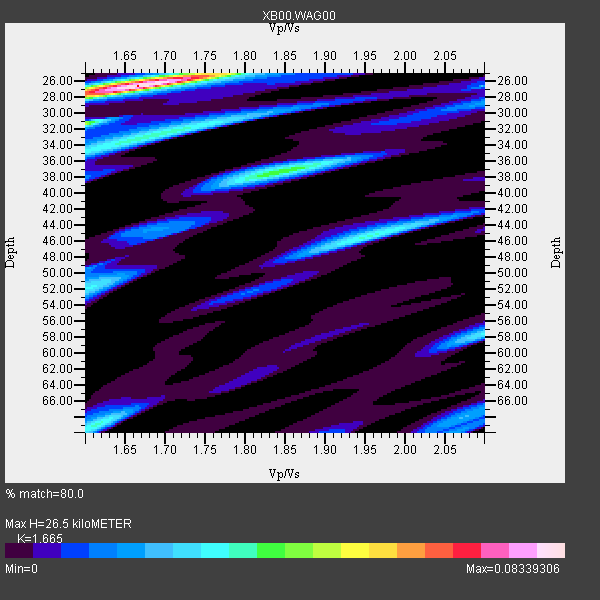
| Crust2 Type: | K2,forearc, New Zealand, 0.7 km seds. |
| Thickness Estimate: | 26 km |
| Thickness StdDev: | 3.3 km |
| Vp/Vs Estimate: | 1.66 |
| Vp/Vs StdDev: | 0.02 |
| Vs Estimate: | 3.881 km/s |
| Poisson's Ratio: | 0.22 |
| Peak Value: | 0.08 |
| Assumed Vp: | 6.461 km/s |
| Ps Weight: | 0.33333334 |
| PpPs Weight: | 0.33333334 |
| PsPs Weight: | 0.33333328 |
| Residual Complexity: | 0.691 |
| Nearby stations H: | +- |
| (2.0 deg) Vp/Vs: | +- |
0 with match > 90% ( 0.0 %) and 2 with match > 80% ( 100.0 %) out of 2.
Download stack as xyz text file.
Azimuth Distribution of Events:

Prior Results for this Station
| Study | Thickness | Vp/Vs | Vp | Vs | Poissons Ratio | Extra |
| EARS | 26 km | 1.66 | 6.461 km/s | 3.881 km/s | 0.22 | |
| Crust2.0 | 35 km | 1.76 | 6.461 km/s | 3.663 km/s | 0.26 | K2,forearc, New Zealand, 0.7 km seds. |
| Global Maxima | 26 km | 1.66 | 6.461 km/s | 3.881 km/s | 0.22 | amp=0.08339306 |
| Local Maxima 1 | 37 km | 1.84 | 6.461 km/s | 3.507 km/s | 0.29 | amp=0.041631773 |
| Local Maxima 2 | 32 km | 1.69 | 6.461 km/s | 3.818 km/s | 0.23 | amp=0.03537858 |
| Local Maxima 3 | 69 km | 1.62 | 6.461 km/s | 4.001 km/s | 0.19 | amp=0.034198727 |
| Local Maxima 4 | 45 km | 1.96 | 6.461 km/s | 3.305 km/s | 0.32 | amp=0.03383998 |
| Predicted Arrivals for vertical incidence (zero ray parameter) | |
| Ps | 2.73 SECOND |
| PpPs | 10.93 SECOND |
| PsPs/PpSs | 13.66 SECOND |
Events Processed for this Station
Download zip of receiver functions as SAC
Plot maxima for each earthquake.
Events Used in the Stack
(2 events)| Radial Match | Distance | Baz | FERegion | Time | Lat/Lon | Depth | Magnitude |
| 89.30279 | 42.2 deg | 318.656 deg | Eastern New Guinea Reg., P.N.G. | 2001/06/05 09:00:05 GMT | (-6.9, 146.4) | 10 km | 5.8 MB, 6.2 MS, 6.4 MW, 6.1 MW |
| 85.10271 | 41.6 deg | 329.136 deg | New Britain Region, P.N.G. | 2001/07/01 01:46:06 GMT | (-4.3, 153.0) | 28 km | 5.8 MB, 6.0 MS, 6.1 MW, 6.0 ME |
Losers
(0 events)| Radial Match | Distance | Baz | FERegion | Time | Lat/Lon | Depth | Magnitude | Reason |
