
Station XB C0104 - 991013
Network: XB14 - Sweetwater Array
Nearby stations (2 deg radius)
| Station | Name | (Lat, Lon) | Start / End | Elevation |
| C0104 | 991013 | (32.75, -100.51) | 2014-03-07 / 2014-12-31 | 634 m |
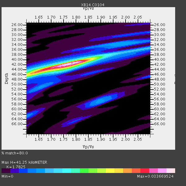
| Crust2 Type: | D8,thick Platform 3 km seds. |
| Thickness Estimate: | 41 km |
| Thickness StdDev: | 0.9 km |
| Vp/Vs Estimate: | 1.78 |
| Vp/Vs StdDev: | 0.04 |
| Vs Estimate: | 3.605 km/s |
| Poisson's Ratio: | 0.27 |
| Peak Value: | 0.03 |
| Assumed Vp: | 6.426 km/s |
| Ps Weight: | 0.33333334 |
| PpPs Weight: | 0.33333334 |
| PsPs Weight: | 0.33333328 |
| Residual Complexity: | 0.509 |
| Nearby stations H: | +- |
| (2.0 deg) Vp/Vs: | +- |
4 with match > 90% ( 16.666666 %) and 9 with match > 80% ( 37.5 %) out of 24.
Download stack as xyz text file.
Azimuth Distribution of Events:

Prior Results for this Station
| Study | Thickness | Vp/Vs | Vp | Vs | Poissons Ratio | Extra |
| EARS | 41 km | 1.78 | 6.426 km/s | 3.605 km/s | 0.27 | |
| Crust2.0 | 46 km | 1.78 | 6.426 km/s | 3.613 km/s | 0.27 | D8,thick Platform 3 km seds. |
| Global Maxima | 41 km | 1.78 | 6.426 km/s | 3.605 km/s | 0.27 | amp=0.033669524 |
| Local Maxima 1 | 45 km | 1.63 | 6.426 km/s | 3.942 km/s | 0.20 | amp=0.021535706 |
| Local Maxima 2 | 39 km | 1.87 | 6.426 km/s | 3.436 km/s | 0.30 | amp=0.009476239 |
| Local Maxima 3 | 57 km | 1.90 | 6.426 km/s | 3.387 km/s | 0.31 | amp=0.007153461 |
| Local Maxima 4 | 35 km | 2.10 | 6.426 km/s | 3.067 km/s | 0.35 | amp=0.0067921355 |
| Predicted Arrivals for vertical incidence (zero ray parameter) | |
| Ps | 5.02 SECOND |
| PpPs | 17.86 SECOND |
| PsPs/PpSs | 22.88 SECOND |
Events Processed for this Station
Download zip of receiver functions as SAC
Plot maxima for each earthquake.
Events Used in the Stack
(9 events)| Radial Match | Distance | Baz | FERegion | Time | Lat/Lon | Depth | Magnitude |
| 99.20806 | 59.3 deg | 147.125 deg | Near Coast Of Northern Chile | 2014/04/01 23:46:46 GMT | (-19.6, -70.8) | 20 km | 8.2 MWW, 8.0 MI, 8.1 MWC |
| 97.33858 | 60.2 deg | 147.311 deg | Near Coast Of Northern Chile | 2014/04/03 02:43:14 GMT | (-20.5, -70.5) | 31 km | 7.7 MWW, 7.4 MI, 7.7 MWC |
| 94.14321 | 59.7 deg | 147.103 deg | Near Coast Of Northern Chile | 2014/03/16 21:16:30 GMT | (-19.9, -70.6) | 20 km | 6.7 MWW, 6.7 MWC, 7.0 MI |
| 91.36026 | 59.4 deg | 147.247 deg | Near Coast Of Northern Chile | 2014/03/22 12:59:59 GMT | (-19.8, -70.9) | 20 km | 6.2 MWW, 6.2 MWB, 6.3 MWC, 6.4 MWC |
| 88.71609 | 42.4 deg | 150.398 deg | Near Coast Of Northern Peru | 2014/03/15 23:51:33 GMT | (-5.6, -81.0) | 29 km | 6.3 MWW, 6.2 MWB, 6.3 MWC |
| 87.37042 | 88.5 deg | 244.274 deg | Tonga Islands | 2014/04/26 06:02:16 GMT | (-20.7, -174.7) | 10 km | 6.5 MWP |
| 86.39654 | 60.2 deg | 147.596 deg | Near Coast Of Northern Chile | 2014/04/04 01:37:51 GMT | (-20.6, -70.7) | 20 km | 6.1 MWP, 6.1 MWB, 6.1 MWW, 6.3 MWC |
| 81.02644 | 59.4 deg | 147.176 deg | Near Coast Of Northern Chile | 2014/03/23 18:20:03 GMT | (-19.7, -70.8) | 35 km | 6.0 MB, 6.2 MWB, 6.2 MWW, 6.3 MWC |
| 80.74961 | 60.0 deg | 147.226 deg | Near Coast Of Northern Chile | 2014/04/03 01:58:31 GMT | (-20.3, -70.6) | 23 km | 6.5 MWW, 6.5 MWB, 6.6 MWC |
Losers
(15 events)| Radial Match | Distance | Baz | FERegion | Time | Lat/Lon | Depth | Magnitude | Reason |
| 87.83308 | 60.5 deg | 147.362 deg | Near Coast Of Northern Chile | 2014/04/03 05:51:44 GMT | (-20.8, -70.4) | 27 km | 5.5 MB, 5.3 MWR | |
| 83.53672 | 60.2 deg | 147.598 deg | Near Coast Of Northern Chile | 2014/04/03 03:11:14 GMT | (-20.6, -70.7) | 10 km | 5.8 MB | |
| 77.10412 | 59.6 deg | 147.273 deg | Near Coast Of Northern Chile | 2014/03/18 21:26:45 GMT | (-20.0, -70.8) | 3.8 km | 5.8 MWW, 5.9 MWC, 6.0 MWR, 6.0 MWB | |
| 76.345505 | 52.0 deg | 149.69 deg | Near Coast Of Peru | 2014/03/15 08:59:21 GMT | (-14.1, -76.3) | 20 km | 6.1 MWW, 6.0 MWB, 6.2 MWC | |
| 73.032646 | 59.5 deg | 147.293 deg | Near Coast Of Northern Chile | 2014/04/02 00:03:12 GMT | (-19.8, -70.9) | 10 km | 5.8 MB | |
| 71.08361 | 59.8 deg | 147.46 deg | Near Coast Of Northern Chile | 2014/04/07 13:43:20 GMT | (-20.2, -70.9) | 7.9 km | 5.8 MWB, 5.7 MWW, 5.7 MWC | |
| 64.92936 | 60.0 deg | 145.499 deg | Northern Chile | 2014/03/31 12:53:05 GMT | (-19.5, -69.2) | 112 km | 5.6 MB, 5.5 MWB, 5.6 MWC, 5.6 MWW | |
| 64.66901 | 59.5 deg | 146.419 deg | Near Coast Of Northern Chile | 2014/04/01 23:59:57 GMT | (-19.5, -70.2) | 22 km | 5.8 MB | |
| 58.128323 | 96.1 deg | 243.03 deg | South Of Fiji Islands | 2014/03/26 03:29:36 GMT | (-26.1, 179.3) | 493 km | 6.5 MWP, 6.3 MWW, 6.3 MWC, 6.4 MWB, 6.4 MWC, 6.5 MI | |
| 56.969784 | 90.5 deg | 242.444 deg | Tonga Islands Region | 2014/03/14 22:49:56 GMT | (-23.4, -175.3) | 14 km | 5.1 MW | |
| 55.676903 | 59.8 deg | 147.443 deg | Near Coast Of Northern Chile | 2014/04/02 04:46:18 GMT | (-20.2, -70.9) | 10 km | 5.8 MB | |
| 55.561447 | 59.3 deg | 147.104 deg | Near Coast Of Northern Chile | 2014/03/24 15:45:31 GMT | (-19.6, -70.8) | 18 km | 5.6 MWB, 5.5 MWR, 5.7 MWC, 5.7 MWW | |
| 51.915215 | 97.6 deg | 318.249 deg | Kyushu, Japan | 2014/03/13 17:06:50 GMT | (33.7, 131.8) | 79 km | 6.3 MWW, 6.3 MWB, 6.3 MWC | |
| 50.864944 | 49.5 deg | 333.683 deg | Northern Alaska | 2014/04/18 18:44:17 GMT | (67.7, -162.5) | 1.0 km | 5.5 MB, 5.4 MI | |
| 47.180016 | 60.0 deg | 147.705 deg | Near Coast Of Northern Chile | 2014/04/08 10:14:32 GMT | (-20.5, -70.9) | 7.1 km | 5.7 MWB, 5.5 MWR, 5.6 MWC, 5.6 MWW |

