
Station XB C0116 - 991025
Network: XB14 - Sweetwater Array
Nearby stations (2 deg radius)
| Station | Name | (Lat, Lon) | Start / End | Elevation |
| C0116 | 991025 | (32.78, -100.37) | 2014-03-07 / 2014-05-01 | 552 m |
| Crust2 Type: | D8,thick Platform 3 km seds. |
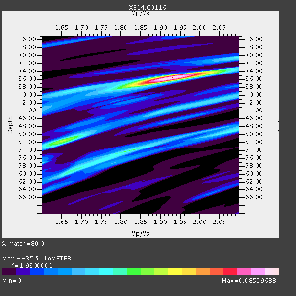
| Thickness Estimate: | 36 km |
| Thickness StdDev: | 0.0 km |
| Vp/Vs Estimate: | 1.93 |
| Vp/Vs StdDev: | 0.01 |
| Vs Estimate: | 3.33 km/s |
| Poisson's Ratio: | 0.32 |
| Peak Value: | 0.09 |
| Assumed Vp: | 6.426 km/s |
| Ps Weight: | 0.33333334 |
| PpPs Weight: | 0.33333334 |
| PsPs Weight: | 0.33333328 |
| Residual Complexity: | 0.661 |
| Nearby stations H: | +- |
| (2.0 deg) Vp/Vs: | +- |
0 with match > 90% ( 0.0 %) and 2 with match > 80% ( 13.333333 %) out of 15.
Download stack as xyz text file.
Azimuth Distribution of Events:

Prior Results for this Station
| Study | Thickness | Vp/Vs | Vp | Vs | Poissons Ratio | Extra |
| EARS | 36 km | 1.93 | 6.426 km/s | 3.33 km/s | 0.32 | |
| Crust2.0 | 46 km | 1.78 | 6.426 km/s | 3.613 km/s | 0.27 | D8,thick Platform 3 km seds. |
| Global Maxima | 36 km | 1.93 | 6.426 km/s | 3.33 km/s | 0.32 | amp=0.08529688 |
| Local Maxima 1 | 52 km | 1.65 | 6.426 km/s | 3.901 km/s | 0.21 | amp=0.046406087 |
| Local Maxima 2 | 54 km | 1.82 | 6.426 km/s | 3.531 km/s | 0.28 | amp=0.03956396 |
| Local Maxima 3 | 60 km | 1.66 | 6.426 km/s | 3.86 km/s | 0.22 | amp=0.03444113 |
| Local Maxima 4 | 48 km | 2.10 | 6.426 km/s | 3.064 km/s | 0.35 | amp=0.028438706 |
| Predicted Arrivals for vertical incidence (zero ray parameter) | |
| Ps | 5.14 SECOND |
| PpPs | 16.19 SECOND |
| PsPs/PpSs | 21.32 SECOND |
Events Processed for this Station
Download zip of receiver functions as SAC
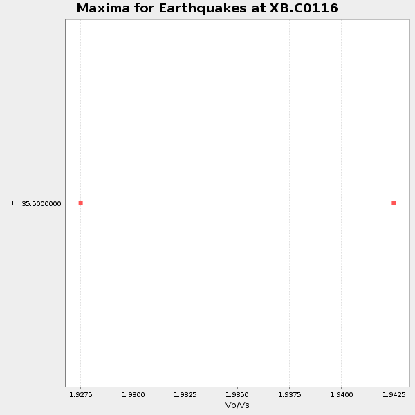
Plot maxima for each earthquake.
Events Used in the Stack
(2 events)| Radial Match | Distance | Baz | FERegion | Time | Lat/Lon | Depth | Magnitude |
| 83.8597 | 59.4 deg | 147.32 deg | Near Coast Of Northern Chile | 2014/03/23 18:20:03 GMT | (-19.7, -70.8) | 35 km | 6.0 MB, 6.2 MWB, 6.2 MWW, 6.3 MWC |
| 82.88125 | 60.0 deg | 147.369 deg | Near Coast Of Northern Chile | 2014/04/03 01:58:31 GMT | (-20.3, -70.6) | 23 km | 6.5 MWW, 6.5 MWB, 6.6 MWC |
Losers
(13 events)| Radial Match | Distance | Baz | FERegion | Time | Lat/Lon | Depth | Magnitude | Reason |
| 99.06118 | 59.3 deg | 147.269 deg | Near Coast Of Northern Chile | 2014/04/01 23:46:46 GMT | (-19.6, -70.8) | 20 km | 8.2 MWW, 8.0 MI, 8.1 MWC | |
| 97.448814 | 60.2 deg | 147.453 deg | Near Coast Of Northern Chile | 2014/04/03 02:43:14 GMT | (-20.5, -70.5) | 31 km | 7.7 MWW, 7.4 MI, 7.7 MWC | |
| 85.689026 | 60.2 deg | 147.74 deg | Near Coast Of Northern Chile | 2014/04/03 03:11:14 GMT | (-20.6, -70.7) | 10 km | 5.8 MB | |
| 85.67815 | 59.4 deg | 146.937 deg | Near Coast Of Northern Chile | 2014/04/02 00:04:54 GMT | (-19.6, -70.5) | 34 km | 5.5 MB | |
| 79.399 | 60.2 deg | 147.738 deg | Near Coast Of Northern Chile | 2014/04/04 01:37:51 GMT | (-20.6, -70.7) | 20 km | 6.1 MWP, 6.1 MWB, 6.1 MWW, 6.3 MWC | |
| 72.53147 | 89.9 deg | 248.537 deg | Fiji Islands Region | 2014/04/03 12:56:36 GMT | (-18.0, -178.4) | 579 km | 5.3 mb | |
| 70.26156 | 59.5 deg | 146.562 deg | Near Coast Of Northern Chile | 2014/04/01 23:59:57 GMT | (-19.5, -70.2) | 22 km | 5.8 MB | |
| 64.235664 | 60.0 deg | 145.64 deg | Northern Chile | 2014/03/31 12:53:05 GMT | (-19.5, -69.2) | 112 km | 5.6 MB, 5.5 MWB, 5.6 MWC, 5.6 MWW | |
| 59.493652 | 59.3 deg | 147.248 deg | Near Coast Of Northern Chile | 2014/03/24 15:45:31 GMT | (-19.6, -70.8) | 18 km | 5.6 MWB, 5.5 MWR, 5.7 MWC, 5.7 MWW | |
| 54.986694 | 96.2 deg | 243.103 deg | South Of Fiji Islands | 2014/03/26 03:29:36 GMT | (-26.1, 179.3) | 493 km | 6.5 MWP, 6.3 MWW, 6.3 MWC, 6.4 MWB, 6.4 MWC, 6.5 MI | |
| 53.124283 | 60.1 deg | 147.673 deg | Near Coast Of Northern Chile | 2014/04/03 09:23:21 GMT | (-20.6, -70.7) | 15 km | 5.6 MB, 5.3 MWR | |
| 53.008 | 59.7 deg | 147.587 deg | Near Coast Of Northern Chile | 2014/04/02 04:46:18 GMT | (-20.2, -70.9) | 10 km | 5.8 MB | |
| 37.010464 | 59.5 deg | 147.598 deg | Near Coast Of Northern Chile | 2014/04/02 11:07:33 GMT | (-20.0, -71.0) | 27 km | 5.4 Mww |

