
Station XB C0132 - 991023
Network: XB14 - Sweetwater Array
Nearby stations (2 deg radius)
| Station | Name | (Lat, Lon) | Start / End | Elevation |
| C0132 | 991023 | (32.72, -100.40) | 2014-03-07 / 2014-05-01 | 569 m |
| Crust2 Type: | D8,thick Platform 3 km seds. |
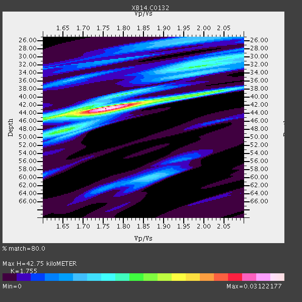
| Thickness Estimate: | 43 km |
| Thickness StdDev: | 7.5 km |
| Vp/Vs Estimate: | 1.75 |
| Vp/Vs StdDev: | 0.04 |
| Vs Estimate: | 3.662 km/s |
| Poisson's Ratio: | 0.26 |
| Peak Value: | 0.03 |
| Assumed Vp: | 6.426 km/s |
| Ps Weight: | 0.33333334 |
| PpPs Weight: | 0.33333334 |
| PsPs Weight: | 0.33333328 |
| Residual Complexity: | 0.627 |
| Nearby stations H: | +- |
| (2.0 deg) Vp/Vs: | +- |
1 with match > 90% ( 5.263158 %) and 3 with match > 80% ( 15.789474 %) out of 19.
Download stack as xyz text file.
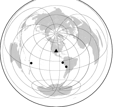
Azimuth Distribution of Events:
Prior Results for this Station
| Study | Thickness | Vp/Vs | Vp | Vs | Poissons Ratio | Extra |
| EARS | 43 km | 1.75 | 6.426 km/s | 3.662 km/s | 0.26 | |
| Crust2.0 | 46 km | 1.78 | 6.426 km/s | 3.613 km/s | 0.27 | D8,thick Platform 3 km seds. |
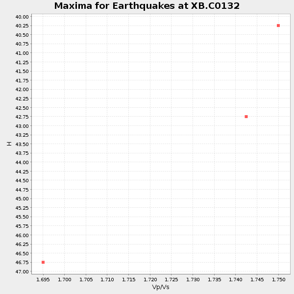
| Global Maxima | 43 km | 1.75 | 6.426 km/s | 3.662 km/s | 0.26 | amp=0.03122177 |
| Local Maxima 1 | 32 km | 1.98 | 6.426 km/s | 3.241 km/s | 0.33 | amp=0.0135169355 |
| Local Maxima 2 | 49 km | 1.63 | 6.426 km/s | 3.948 km/s | 0.20 | amp=0.0129109165 |
| Local Maxima 3 | 39 km | 2.01 | 6.426 km/s | 3.197 km/s | 0.34 | amp=0.010850873 |
| Local Maxima 4 | 60 km | 1.86 | 6.426 km/s | 3.45 km/s | 0.30 | amp=0.010459924 |
| Predicted Arrivals for vertical incidence (zero ray parameter) | |
| Ps | 5.02 SECOND |
| PpPs | 18.33 SECOND |
| PsPs/PpSs | 23.35 SECOND |
Events Processed for this Station
Download zip of receiver functions as SAC
Plot maxima for each earthquake.
Events Used in the Stack
(3 events)| Radial Match | Distance | Baz | FERegion | Time | Lat/Lon | Depth | Magnitude |
| 92.701126 | 59.6 deg | 147.203 deg | Near Coast Of Northern Chile | 2014/03/16 21:16:30 GMT | (-19.9, -70.6) | 20 km | 6.7 MWW, 6.7 MWC, 7.0 MI |
| 88.975746 | 42.3 deg | 150.537 deg | Near Coast Of Northern Peru | 2014/03/15 23:51:33 GMT | (-5.6, -81.0) | 29 km | 6.3 MWW, 6.2 MWB, 6.3 MWC |
| 80.90507 | 88.6 deg | 244.339 deg | Tonga Islands | 2014/04/26 06:02:16 GMT | (-20.7, -174.7) | 10 km | 6.5 MWP |
Losers
(16 events)| Radial Match | Distance | Baz | FERegion | Time | Lat/Lon | Depth | Magnitude | Reason |
| 99.23719 | 59.3 deg | 147.226 deg | Near Coast Of Northern Chile | 2014/04/01 23:46:46 GMT | (-19.6, -70.8) | 20 km | 8.2 MWW, 8.0 MI, 8.1 MWC | |
| 97.775856 | 60.2 deg | 147.411 deg | Near Coast Of Northern Chile | 2014/04/03 02:43:14 GMT | (-20.5, -70.5) | 31 km | 7.7 MWW, 7.4 MI, 7.7 MWC | |
| 94.72566 | 90.6 deg | 242.555 deg | Tonga Islands Region | 2014/03/12 20:10:34 GMT | (-23.4, -175.3) | 30 km | 5.0 MW | |
| 90.357605 | 60.1 deg | 147.665 deg | Near Coast Of Northern Chile | 2014/04/03 04:17:57 GMT | (-20.6, -70.7) | 18 km | 5.2 mb | |
| 82.02341 | 60.2 deg | 147.698 deg | Near Coast Of Northern Chile | 2014/04/03 03:11:14 GMT | (-20.6, -70.7) | 10 km | 5.8 MB | |
| 79.32889 | 59.3 deg | 147.277 deg | Near Coast Of Northern Chile | 2014/03/23 18:20:03 GMT | (-19.7, -70.8) | 35 km | 6.0 MB, 6.2 MWB, 6.2 MWW, 6.3 MWC | |
| 75.28726 | 51.9 deg | 149.806 deg | Near Coast Of Peru | 2014/03/15 08:59:21 GMT | (-14.1, -76.3) | 20 km | 6.1 MWW, 6.0 MWB, 6.2 MWC | |
| 75.239914 | 60.1 deg | 147.697 deg | Near Coast Of Northern Chile | 2014/04/04 01:37:51 GMT | (-20.6, -70.7) | 20 km | 6.1 MWP, 6.1 MWB, 6.1 MWW, 6.3 MWC | |
| 70.42171 | 59.7 deg | 147.561 deg | Near Coast Of Northern Chile | 2014/04/07 13:43:20 GMT | (-20.2, -70.9) | 7.9 km | 5.8 MWB, 5.7 MWW, 5.7 MWC | |
| 66.01522 | 73.2 deg | 319.421 deg | Kuril Islands | 2014/04/07 09:34:49 GMT | (50.4, 156.3) | 85 km | 5.2 MW | |
| 63.301743 | 59.4 deg | 146.519 deg | Near Coast Of Northern Chile | 2014/04/01 23:59:57 GMT | (-19.5, -70.2) | 22 km | 5.8 MB | |
| 57.59008 | 59.6 deg | 147.374 deg | Near Coast Of Northern Chile | 2014/03/18 21:26:45 GMT | (-20.0, -70.8) | 3.8 km | 5.8 MWW, 5.9 MWC, 6.0 MWR, 6.0 MWB | |
| 56.84874 | 49.6 deg | 333.683 deg | Northern Alaska | 2014/04/18 18:44:17 GMT | (67.7, -162.5) | 1.0 km | 5.5 MB, 5.4 MI | |
| 52.132526 | 96.2 deg | 243.085 deg | South Of Fiji Islands | 2014/03/26 03:29:36 GMT | (-26.1, 179.3) | 493 km | 6.5 MWP, 6.3 MWW, 6.3 MWC, 6.4 MWB, 6.4 MWC, 6.5 MI | |
| 50.990097 | 63.8 deg | 148.134 deg | Northern Chile | 2014/03/20 18:41:32 GMT | (-24.0, -69.2) | 96 km | 5.1 MW | |
| 48.493027 | 59.9 deg | 147.799 deg | Near Coast Of Northern Chile | 2014/04/06 14:06:09 GMT | (-20.4, -71.0) | 20 km | 5.3 MW |

