
Station XB C0134 - 991006
Network: XB14 - Sweetwater Array
Nearby stations (2 deg radius)
| Station | Name | (Lat, Lon) | Start / End | Elevation |
| C0134 | 991006 | (32.74, -100.55) | 2014-03-07 / 2014-05-01 | 627 m |
| Crust2 Type: | D8,thick Platform 3 km seds. |
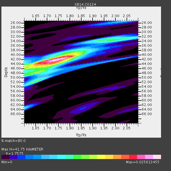
| Thickness Estimate: | 42 km |
| Thickness StdDev: | 4.0 km |
| Vp/Vs Estimate: | 1.76 |
| Vp/Vs StdDev: | 0.08 |
| Vs Estimate: | 3.656 km/s |
| Poisson's Ratio: | 0.26 |
| Peak Value: | 0.03 |
| Assumed Vp: | 6.426 km/s |
| Ps Weight: | 0.33333334 |
| PpPs Weight: | 0.33333334 |
| PsPs Weight: | 0.33333328 |
| Residual Complexity: | 0.613 |
| Nearby stations H: | +- |
| (2.0 deg) Vp/Vs: | +- |
2 with match > 90% ( 7.142857 %) and 5 with match > 80% ( 17.857143 %) out of 28.
Download stack as xyz text file.
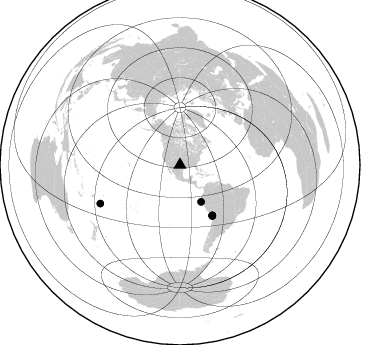
Azimuth Distribution of Events:
Prior Results for this Station
| Study | Thickness | Vp/Vs | Vp | Vs | Poissons Ratio | Extra |
| EARS | 42 km | 1.76 | 6.426 km/s | 3.656 km/s | 0.26 | |
| Crust2.0 | 46 km | 1.78 | 6.426 km/s | 3.613 km/s | 0.27 | D8,thick Platform 3 km seds. |
| Global Maxima | 42 km | 1.76 | 6.426 km/s | 3.656 km/s | 0.26 | amp=0.025613455 |
| Local Maxima 1 | 45 km | 1.60 | 6.426 km/s | 4.016 km/s | 0.18 | amp=0.014037831 |
| Local Maxima 2 | 52 km | 1.65 | 6.426 km/s | 3.901 km/s | 0.21 | amp=0.012979868 |
| Local Maxima 3 | 40 km | 1.81 | 6.426 km/s | 3.56 km/s | 0.28 | amp=0.011320826 |
| Local Maxima 4 | 33 km | 2.02 | 6.426 km/s | 3.177 km/s | 0.34 | amp=0.01043607 |
| Predicted Arrivals for vertical incidence (zero ray parameter) | |
| Ps | 4.92 SECOND |
| PpPs | 17.92 SECOND |
| PsPs/PpSs | 22.84 SECOND |
Events Processed for this Station
Download zip of receiver functions as SAC
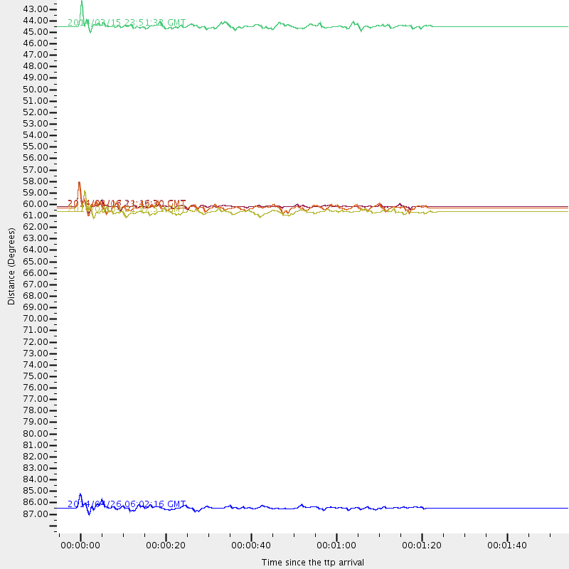
Plot maxima for each earthquake.
Events Used in the Stack
(5 events)| Radial Match | Distance | Baz | FERegion | Time | Lat/Lon | Depth | Magnitude |
| 94.36268 | 59.7 deg | 147.066 deg | Near Coast Of Northern Chile | 2014/03/16 21:16:30 GMT | (-19.9, -70.6) | 20 km | 6.7 MWW, 6.7 MWC, 7.0 MI |
| 91.09689 | 42.4 deg | 150.345 deg | Near Coast Of Northern Peru | 2014/03/15 23:51:33 GMT | (-5.6, -81.0) | 29 km | 6.3 MWW, 6.2 MWB, 6.3 MWC |
| 87.10373 | 88.5 deg | 244.255 deg | Tonga Islands | 2014/04/26 06:02:16 GMT | (-20.7, -174.7) | 10 km | 6.5 MWP |
| 86.58803 | 60.2 deg | 147.56 deg | Near Coast Of Northern Chile | 2014/04/04 01:37:51 GMT | (-20.6, -70.7) | 20 km | 6.1 MWP, 6.1 MWB, 6.1 MWW, 6.3 MWC |
| 81.058395 | 59.8 deg | 147.423 deg | Near Coast Of Northern Chile | 2014/04/07 13:43:20 GMT | (-20.2, -70.9) | 7.9 km | 5.8 MWB, 5.7 MWW, 5.7 MWC |
Losers
(23 events)| Radial Match | Distance | Baz | FERegion | Time | Lat/Lon | Depth | Magnitude | Reason |
| 99.09103 | 59.3 deg | 147.088 deg | Near Coast Of Northern Chile | 2014/04/01 23:46:46 GMT | (-19.6, -70.8) | 20 km | 8.2 MWW, 8.0 MI, 8.1 MWC | |
| 97.690865 | 60.3 deg | 147.275 deg | Near Coast Of Northern Chile | 2014/04/03 02:43:14 GMT | (-20.5, -70.5) | 31 km | 7.7 MWW, 7.4 MI, 7.7 MWC | |
| 79.02701 | 52.0 deg | 149.647 deg | Near Coast Of Peru | 2014/03/15 08:59:21 GMT | (-14.1, -76.3) | 20 km | 6.1 MWW, 6.0 MWB, 6.2 MWC | |
| 77.12957 | 60.0 deg | 147.19 deg | Near Coast Of Northern Chile | 2014/04/03 01:58:31 GMT | (-20.3, -70.6) | 23 km | 6.5 MWW, 6.5 MWB, 6.6 MWC | |
| 76.652245 | 86.7 deg | 244.798 deg | Tonga Islands | 2014/04/10 22:27:10 GMT | (-19.2, -173.5) | 14 km | 5.6 MWP | |
| 76.407585 | 59.4 deg | 147.139 deg | Near Coast Of Northern Chile | 2014/03/23 18:20:03 GMT | (-19.7, -70.8) | 35 km | 6.0 MB, 6.2 MWB, 6.2 MWW, 6.3 MWC | |
| 74.57376 | 60.3 deg | 147.615 deg | Near Coast Of Northern Chile | 2014/04/11 00:01:44 GMT | (-20.7, -70.7) | 18 km | 6.0 MB | |
| 74.005295 | 60.2 deg | 147.561 deg | Near Coast Of Northern Chile | 2014/04/03 03:11:14 GMT | (-20.6, -70.7) | 10 km | 5.8 MB | |
| 72.98699 | 60.5 deg | 147.325 deg | Near Coast Of Northern Chile | 2014/04/03 05:51:44 GMT | (-20.8, -70.4) | 27 km | 5.5 MB, 5.3 MWR | |
| 72.0914 | 59.6 deg | 147.236 deg | Near Coast Of Northern Chile | 2014/03/18 21:26:45 GMT | (-20.0, -70.8) | 3.8 km | 5.8 MWW, 5.9 MWC, 6.0 MWR, 6.0 MWB | |
| 69.68886 | 59.3 deg | 147.071 deg | Near Coast Of Northern Chile | 2014/04/02 00:06:44 GMT | (-19.6, -70.8) | 10 km | 5.7 MB | |
| 66.647415 | 86.1 deg | 249.901 deg | Fiji Islands Region | 2014/04/09 20:29:02 GMT | (-14.7, -176.0) | 327 km | 5.5 MW | |
| 64.98431 | 59.3 deg | 147.067 deg | Near Coast Of Northern Chile | 2014/03/24 15:45:31 GMT | (-19.6, -70.8) | 18 km | 5.6 MWB, 5.5 MWR, 5.7 MWC, 5.7 MWW | |
| 64.13559 | 96.1 deg | 243.011 deg | South Of Fiji Islands | 2014/03/26 03:29:36 GMT | (-26.1, 179.3) | 493 km | 6.5 MWP, 6.3 MWW, 6.3 MWC, 6.4 MWB, 6.4 MWC, 6.5 MI | |
| 63.907803 | 60.0 deg | 147.661 deg | Near Coast Of Northern Chile | 2014/04/06 14:06:09 GMT | (-20.4, -71.0) | 20 km | 5.3 MW | |
| 63.089176 | 70.0 deg | 144.745 deg | Santiago Del Estero Prov., Arg. | 2014/04/18 07:46:57 GMT | (-27.7, -62.8) | 610 km | 5.6 MW | |
| 62.623352 | 60.2 deg | 147.537 deg | Near Coast Of Northern Chile | 2014/04/13 12:11:30 GMT | (-20.6, -70.7) | 13 km | 5.5 MWW, 5.3 MWR | |
| 61.386658 | 59.5 deg | 146.382 deg | Near Coast Of Northern Chile | 2014/04/01 23:59:57 GMT | (-19.5, -70.2) | 22 km | 5.8 MB | |
| 60.016644 | 60.2 deg | 147.528 deg | Near Coast Of Northern Chile | 2014/04/03 04:17:57 GMT | (-20.6, -70.7) | 18 km | 5.2 mb | |
| 55.27814 | 60.0 deg | 145.462 deg | Northern Chile | 2014/03/31 12:53:05 GMT | (-19.5, -69.2) | 112 km | 5.6 MB, 5.5 MWB, 5.6 MWC, 5.6 MWW | |
| 54.01965 | 67.0 deg | 346.582 deg | Laptev Sea | 2014/04/11 13:27:05 GMT | (74.9, 133.8) | 10 km | 4.2 mb | |
| 50.37401 | 49.5 deg | 333.691 deg | Northern Alaska | 2014/04/18 18:44:17 GMT | (67.7, -162.5) | 1.0 km | 5.5 MB, 5.4 MI | |
| 45.286587 | 73.1 deg | 319.364 deg | Kuril Islands | 2014/04/07 09:34:49 GMT | (50.4, 156.3) | 85 km | 5.2 MW |

