
Station XB C0179 - 991010
Network: XB14 - Sweetwater Array
Nearby stations (2 deg radius)

| Station | Name | (Lat, Lon) | Start / End | Elevation |
| C0179 | 991010 | (32.78, -100.54) | 2014-03-07 / 2014-05-01 | 598 m |
| Crust2 Type: | D8,thick Platform 3 km seds. |
| Thickness Estimate: | 43 km |
| Thickness StdDev: | 2.2 km |
| Vp/Vs Estimate: | 1.72 |
| Vp/Vs StdDev: | 0.02 |
| Vs Estimate: | 3.736 km/s |
| Poisson's Ratio: | 0.24 |
| Peak Value: | 0.05 |
| Assumed Vp: | 6.426 km/s |
| Ps Weight: | 0.33333334 |
| PpPs Weight: | 0.33333334 |
| PsPs Weight: | 0.33333328 |
| Residual Complexity: | 0.382 |
| Nearby stations H: | +- |
| (2.0 deg) Vp/Vs: | +- |
2 with match > 90% ( 7.142857 %) and 6 with match > 80% ( 21.428572 %) out of 28.
Download stack as xyz text file.
Azimuth Distribution of Events:

Prior Results for this Station
| Study | Thickness | Vp/Vs | Vp | Vs | Poissons Ratio | Extra |
| EARS | 43 km | 1.72 | 6.426 km/s | 3.736 km/s | 0.24 | |
| Crust2.0 | 46 km | 1.78 | 6.426 km/s | 3.613 km/s | 0.27 | D8,thick Platform 3 km seds. |
| Global Maxima | 43 km | 1.72 | 6.426 km/s | 3.736 km/s | 0.24 | amp=0.05198729 |
| Local Maxima 1 | 44 km | 1.73 | 6.426 km/s | 3.715 km/s | 0.25 | amp=0.019168619 |
| Local Maxima 2 | 42 km | 1.75 | 6.426 km/s | 3.672 km/s | 0.26 | amp=0.015383427 |
| Local Maxima 3 | 63 km | 1.85 | 6.426 km/s | 3.478 km/s | 0.29 | amp=0.009167922 |
| Local Maxima 4 | 39 km | 1.82 | 6.426 km/s | 3.541 km/s | 0.28 | amp=0.008921179 |
| Predicted Arrivals for vertical incidence (zero ray parameter) | |
| Ps | 4.85 SECOND |
| PpPs | 18.31 SECOND |
| PsPs/PpSs | 23.15 SECOND |
Events Processed for this Station
Download zip of receiver functions as SAC
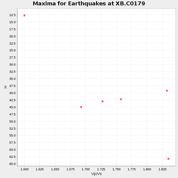
Plot maxima for each earthquake.
Events Used in the Stack
(6 events)| Radial Match | Distance | Baz | FERegion | Time | Lat/Lon | Depth | Magnitude |
| 93.91419 | 59.7 deg | 147.086 deg | Near Coast Of Northern Chile | 2014/03/16 21:16:30 GMT | (-19.9, -70.6) | 20 km | 6.7 MWW, 6.7 MWC, 7.0 MI |
| 90.20628 | 88.5 deg | 244.259 deg | Tonga Islands | 2014/04/26 06:02:16 GMT | (-20.7, -174.7) | 10 km | 6.5 MWP |
| 89.72581 | 60.3 deg | 147.579 deg | Near Coast Of Northern Chile | 2014/04/04 01:37:51 GMT | (-20.6, -70.7) | 20 km | 6.1 MWP, 6.1 MWB, 6.1 MWW, 6.3 MWC |
| 87.89627 | 42.4 deg | 150.377 deg | Near Coast Of Northern Peru | 2014/03/15 23:51:33 GMT | (-5.6, -81.0) | 29 km | 6.3 MWW, 6.2 MWB, 6.3 MWC |
| 84.70529 | 59.5 deg | 147.159 deg | Near Coast Of Northern Chile | 2014/03/23 18:20:03 GMT | (-19.7, -70.8) | 35 km | 6.0 MB, 6.2 MWB, 6.2 MWW, 6.3 MWC |
| 81.88507 | 60.0 deg | 147.209 deg | Near Coast Of Northern Chile | 2014/04/03 01:58:31 GMT | (-20.3, -70.6) | 23 km | 6.5 MWW, 6.5 MWB, 6.6 MWC |
Losers
(22 events)| Radial Match | Distance | Baz | FERegion | Time | Lat/Lon | Depth | Magnitude | Reason |
| 98.859695 | 59.4 deg | 147.108 deg | Near Coast Of Northern Chile | 2014/04/01 23:46:46 GMT | (-19.6, -70.8) | 20 km | 8.2 MWW, 8.0 MI, 8.1 MWC | |
| 97.59969 | 60.3 deg | 147.294 deg | Near Coast Of Northern Chile | 2014/04/03 02:43:14 GMT | (-20.5, -70.5) | 31 km | 7.7 MWW, 7.4 MI, 7.7 MWC | |
| 76.34529 | 59.8 deg | 147.443 deg | Near Coast Of Northern Chile | 2014/04/07 13:43:20 GMT | (-20.2, -70.9) | 7.9 km | 5.8 MWB, 5.7 MWW, 5.7 MWC | |
| 75.86859 | 60.4 deg | 147.635 deg | Near Coast Of Northern Chile | 2014/04/11 00:01:44 GMT | (-20.7, -70.7) | 18 km | 6.0 MB | |
| 75.523186 | 59.7 deg | 147.256 deg | Near Coast Of Northern Chile | 2014/03/18 21:26:45 GMT | (-20.0, -70.8) | 3.8 km | 5.8 MWW, 5.9 MWC, 6.0 MWR, 6.0 MWB | |
| 74.40542 | 60.3 deg | 147.581 deg | Near Coast Of Northern Chile | 2014/04/03 03:11:14 GMT | (-20.6, -70.7) | 10 km | 5.8 MB | |
| 72.064316 | 59.4 deg | 147.091 deg | Near Coast Of Northern Chile | 2014/04/02 00:06:44 GMT | (-19.6, -70.8) | 10 km | 5.7 MB | |
| 68.99904 | 52.1 deg | 149.671 deg | Near Coast Of Peru | 2014/03/15 08:59:21 GMT | (-14.1, -76.3) | 20 km | 6.1 MWW, 6.0 MWB, 6.2 MWC | |
| 68.32273 | 59.7 deg | 147.411 deg | Near Coast Of Northern Chile | 2014/04/19 20:54:42 GMT | (-20.0, -70.9) | 9.0 km | 5.8 MWR | |
| 67.8226 | 60.5 deg | 147.345 deg | Near Coast Of Northern Chile | 2014/04/03 05:51:44 GMT | (-20.8, -70.4) | 27 km | 5.5 MB, 5.3 MWR | |
| 65.101425 | 59.5 deg | 146.402 deg | Near Coast Of Northern Chile | 2014/04/01 23:59:57 GMT | (-19.5, -70.2) | 22 km | 5.8 MB | |
| 64.77792 | 49.5 deg | 333.675 deg | Northern Alaska | 2014/04/18 18:44:17 GMT | (67.7, -162.5) | 1.0 km | 5.5 MB, 5.4 MI | |
| 62.82422 | 88.1 deg | 92.633 deg | North Of Ascension Island | 2014/04/30 15:52:42 GMT | (-1.2, -13.5) | 14 km | 5.8 MW | |
| 62.62313 | 60.2 deg | 147.548 deg | Near Coast Of Northern Chile | 2014/04/03 04:17:57 GMT | (-20.6, -70.7) | 18 km | 5.2 mb | |
| 62.164036 | 59.5 deg | 147.214 deg | Near Coast Of Northern Chile | 2014/03/24 11:40:44 GMT | (-19.8, -70.8) | 23 km | 5.5 MB, 5.5 MWR, 5.6 MWW, 5.7 MWC | |
| 60.11797 | 73.0 deg | 319.359 deg | Kuril Islands | 2014/04/07 09:34:49 GMT | (50.4, 156.3) | 85 km | 5.2 MW | |
| 55.478916 | 96.1 deg | 243.019 deg | South Of Fiji Islands | 2014/03/26 03:29:36 GMT | (-26.1, 179.3) | 493 km | 6.5 MWP, 6.3 MWW, 6.3 MWC, 6.4 MWB, 6.4 MWC, 6.5 MI | |
| 55.371967 | 70.1 deg | 144.759 deg | Santiago Del Estero Prov., Arg. | 2014/04/18 07:46:57 GMT | (-27.7, -62.8) | 610 km | 5.6 MW | |
| 51.479267 | 60.1 deg | 147.688 deg | Near Coast Of Northern Chile | 2014/04/08 10:14:32 GMT | (-20.5, -70.9) | 7.1 km | 5.7 MWB, 5.5 MWR, 5.6 MWC, 5.6 MWW | |
| 50.622765 | 49.5 deg | 333.721 deg | Northern Alaska | 2014/04/18 18:56:47 GMT | (67.7, -162.5) | 17 km | 5.7 MW | |
| 48.913956 | 59.9 deg | 147.34 deg | Near Coast Of Northern Chile | 2014/04/15 16:21:17 GMT | (-20.2, -70.7) | 18 km | 5.1 MW | |
| 47.8647 | 60.0 deg | 145.482 deg | Northern Chile | 2014/03/31 12:53:05 GMT | (-19.5, -69.2) | 112 km | 5.6 MB, 5.5 MWB, 5.6 MWC, 5.6 MWW |

