
Station XB C0228 - 991002
Network: XB14 - Sweetwater Array
Nearby stations (2 deg radius)
| Station | Name | (Lat, Lon) | Start / End | Elevation |
| C0228 | 991002 | (32.67, -100.61) | 2014-03-07 / 2014-12-31 | 662 m |
| Crust2 Type: | D8,thick Platform 3 km seds. |
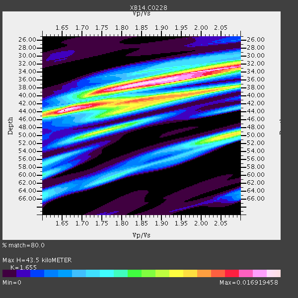
| Thickness Estimate: | 44 km |
| Thickness StdDev: | 4.5 km |
| Vp/Vs Estimate: | 1.65 |
| Vp/Vs StdDev: | 0.13 |
| Vs Estimate: | 3.883 km/s |
| Poisson's Ratio: | 0.21 |
| Peak Value: | 0.02 |
| Assumed Vp: | 6.426 km/s |
| Ps Weight: | 0.33333334 |
| PpPs Weight: | 0.33333334 |
| PsPs Weight: | 0.33333328 |
| Residual Complexity: | 0.868 |
| Nearby stations H: | +- |
| (2.0 deg) Vp/Vs: | +- |
2 with match > 90% ( 10.526316 %) and 6 with match > 80% ( 31.578947 %) out of 19.
Download stack as xyz text file.
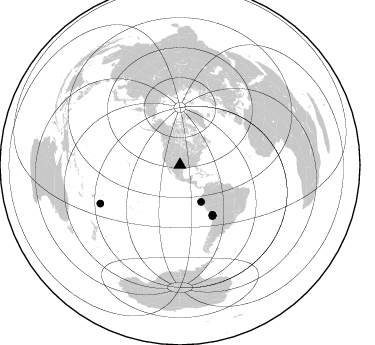
Azimuth Distribution of Events:
Prior Results for this Station
| Study | Thickness | Vp/Vs | Vp | Vs | Poissons Ratio | Extra |
| EARS | 44 km | 1.65 | 6.426 km/s | 3.883 km/s | 0.21 | |
| Crust2.0 | 46 km | 1.78 | 6.426 km/s | 3.613 km/s | 0.27 | D8,thick Platform 3 km seds. |
| Global Maxima | 44 km | 1.65 | 6.426 km/s | 3.883 km/s | 0.21 | amp=0.016919458 |
| Local Maxima 1 | 34 km | 2.02 | 6.426 km/s | 3.181 km/s | 0.34 | amp=0.016617138 |
| Local Maxima 2 | 38 km | 1.82 | 6.426 km/s | 3.536 km/s | 0.28 | amp=0.014726437 |
| Local Maxima 3 | 50 km | 2.07 | 6.426 km/s | 3.101 km/s | 0.35 | amp=0.011399043 |
| Local Maxima 4 | 43 km | 1.83 | 6.426 km/s | 3.507 km/s | 0.29 | amp=0.0106455255 |
| Predicted Arrivals for vertical incidence (zero ray parameter) | |
| Ps | 4.43 SECOND |
| PpPs | 17.97 SECOND |
| PsPs/PpSs | 22.41 SECOND |
Events Processed for this Station
Download zip of receiver functions as SAC
Plot maxima for each earthquake.
Events Used in the Stack
(6 events)| Radial Match | Distance | Baz | FERegion | Time | Lat/Lon | Depth | Magnitude |
| 99.31401 | 59.3 deg | 147.002 deg | Near Coast Of Northern Chile | 2014/04/01 23:46:46 GMT | (-19.6, -70.8) | 20 km | 8.2 MWW, 8.0 MI, 8.1 MWC |
| 91.95842 | 59.6 deg | 146.98 deg | Near Coast Of Northern Chile | 2014/03/16 21:16:30 GMT | (-19.9, -70.6) | 20 km | 6.7 MWW, 6.7 MWC, 7.0 MI |
| 85.939964 | 60.0 deg | 147.105 deg | Near Coast Of Northern Chile | 2014/04/03 01:58:31 GMT | (-20.3, -70.6) | 23 km | 6.5 MWW, 6.5 MWB, 6.6 MWC |
| 83.26543 | 88.4 deg | 244.221 deg | Tonga Islands | 2014/04/26 06:02:16 GMT | (-20.7, -174.7) | 10 km | 6.5 MWP |
| 82.44848 | 60.2 deg | 147.476 deg | Near Coast Of Northern Chile | 2014/04/04 01:37:51 GMT | (-20.6, -70.7) | 20 km | 6.1 MWP, 6.1 MWB, 6.1 MWW, 6.3 MWC |
| 80.24558 | 42.4 deg | 150.218 deg | Near Coast Of Northern Peru | 2014/03/15 23:51:33 GMT | (-5.6, -81.0) | 29 km | 6.3 MWW, 6.2 MWB, 6.3 MWC |
Losers
(13 events)| Radial Match | Distance | Baz | FERegion | Time | Lat/Lon | Depth | Magnitude | Reason |
| 75.76905 | 60.2 deg | 147.477 deg | Near Coast Of Northern Chile | 2014/04/03 03:11:14 GMT | (-20.6, -70.7) | 10 km | 5.8 MB | |
| 74.60416 | 52.0 deg | 149.546 deg | Near Coast Of Peru | 2014/03/15 08:59:21 GMT | (-14.1, -76.3) | 20 km | 6.1 MWW, 6.0 MWB, 6.2 MWC | |
| 63.089806 | 90.5 deg | 242.452 deg | Tonga Islands Region | 2014/03/13 06:09:23 GMT | (-23.4, -175.4) | 18 km | 5.3 MW | |
| 61.472107 | 59.6 deg | 147.15 deg | Near Coast Of Northern Chile | 2014/03/18 21:26:45 GMT | (-20.0, -70.8) | 3.8 km | 5.8 MWW, 5.9 MWC, 6.0 MWR, 6.0 MWB | |
| 58.50587 | 59.7 deg | 147.321 deg | Near Coast Of Northern Chile | 2014/04/02 04:46:18 GMT | (-20.2, -70.9) | 10 km | 5.8 MB | |
| 57.86712 | 86.7 deg | 244.764 deg | Tonga Islands | 2014/04/10 22:27:10 GMT | (-19.2, -173.5) | 14 km | 5.6 MWP | |
| 56.102055 | 59.6 deg | 147.306 deg | Near Coast Of Northern Chile | 2014/04/19 20:54:42 GMT | (-20.0, -70.9) | 9.0 km | 5.8 MWR | |
| 55.799458 | 70.6 deg | 154.328 deg | Near Coast Of Central Chile | 2014/04/05 02:22:38 GMT | (-32.8, -71.6) | 40 km | 5.6 MWC, 5.6 MWC | |
| 55.730343 | 49.6 deg | 333.725 deg | Northern Alaska | 2014/04/18 18:44:17 GMT | (67.7, -162.5) | 1.0 km | 5.5 MB, 5.4 MI | |
| 52.5902 | 59.5 deg | 146.296 deg | Near Coast Of Northern Chile | 2014/04/01 23:59:57 GMT | (-19.5, -70.2) | 22 km | 5.8 MB | |
| 46.815266 | 59.7 deg | 147.305 deg | Near Coast Of Northern Chile | 2014/03/18 14:35:58 GMT | (-20.1, -70.8) | 26 km | 5.1 MW | |
| 44.67113 | 97.6 deg | 318.179 deg | Kyushu, Japan | 2014/03/13 17:06:50 GMT | (33.7, 131.8) | 79 km | 6.3 MWW, 6.3 MWB, 6.3 MWC | |
| 43.513073 | 60.0 deg | 145.377 deg | Northern Chile | 2014/03/31 12:53:05 GMT | (-19.5, -69.2) | 112 km | 5.6 MB, 5.5 MWB, 5.6 MWC, 5.6 MWW |

