
Station XB C0272 - 991009
Network: XB14 - Sweetwater Array
Nearby stations (2 deg radius)
| Station | Name | (Lat, Lon) | Start / End | Elevation |
| C0272 | 991009 | (32.76, -100.53) | 2014-03-07 / 2014-05-01 | 598 m |
| Crust2 Type: | D8,thick Platform 3 km seds. |
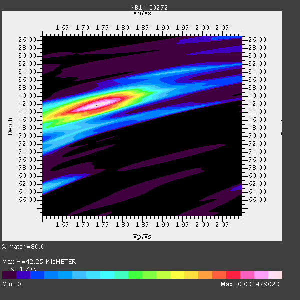
| Thickness Estimate: | 42 km |
| Thickness StdDev: | 2.2 km |
| Vp/Vs Estimate: | 1.74 |
| Vp/Vs StdDev: | 0.04 |
| Vs Estimate: | 3.704 km/s |
| Poisson's Ratio: | 0.25 |
| Peak Value: | 0.03 |
| Assumed Vp: | 6.426 km/s |
| Ps Weight: | 0.33333334 |
| PpPs Weight: | 0.33333334 |
| PsPs Weight: | 0.33333328 |
| Residual Complexity: | 0.590 |
| Nearby stations H: | 42 km +- 0.7 km |
| (2.0 deg) Vp/Vs: | 1.75 +- 0.04 |
1 with match > 90% ( 3.5714285 %) and 4 with match > 80% ( 14.285714 %) out of 28.
Download stack as xyz text file.
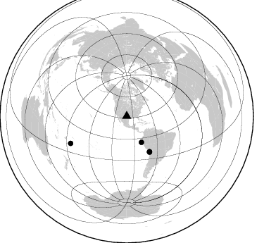
Azimuth Distribution of Events:
Prior Results for this Station
| Study | Thickness | Vp/Vs | Vp | Vs | Poissons Ratio | Extra |
| EARS | 42 km | 1.74 | 6.426 km/s | 3.704 km/s | 0.25 | |
| Crust2.0 | 46 km | 1.78 | 6.426 km/s | 3.613 km/s | 0.27 | D8,thick Platform 3 km seds. |
| Global Maxima | 42 km | 1.74 | 6.426 km/s | 3.704 km/s | 0.25 | amp=0.031479023 |
| Local Maxima 1 | 40 km | 1.77 | 6.426 km/s | 3.636 km/s | 0.26 | amp=0.019075986 |
| Local Maxima 2 | 46 km | 1.60 | 6.426 km/s | 4.016 km/s | 0.18 | amp=0.0151675735 |
| Local Maxima 3 | 43 km | 1.77 | 6.426 km/s | 3.625 km/s | 0.27 | amp=0.011406669 |
| Local Maxima 4 | 63 km | 1.61 | 6.426 km/s | 3.985 km/s | 0.19 | amp=0.010455995 |
| Predicted Arrivals for vertical incidence (zero ray parameter) | |
| Ps | 4.83 SECOND |
| PpPs | 17.98 SECOND |
| PsPs/PpSs | 22.81 SECOND |
Events Processed for this Station
Download zip of receiver functions as SAC
Plot maxima for each earthquake.
Events Used in the Stack
(4 events)| Radial Match | Distance | Baz | FERegion | Time | Lat/Lon | Depth | Magnitude |
| 93.90961 | 59.7 deg | 147.088 deg | Near Coast Of Northern Chile | 2014/03/16 21:16:30 GMT | (-19.9, -70.6) | 20 km | 6.7 MWW, 6.7 MWC, 7.0 MI |
| 89.700714 | 60.2 deg | 147.582 deg | Near Coast Of Northern Chile | 2014/04/04 01:37:51 GMT | (-20.6, -70.7) | 20 km | 6.1 MWP, 6.1 MWB, 6.1 MWW, 6.3 MWC |
| 88.62171 | 42.4 deg | 150.377 deg | Near Coast Of Northern Peru | 2014/03/15 23:51:33 GMT | (-5.6, -81.0) | 29 km | 6.3 MWW, 6.2 MWB, 6.3 MWC |
| 86.50861 | 88.5 deg | 244.265 deg | Tonga Islands | 2014/04/26 06:02:16 GMT | (-20.7, -174.7) | 10 km | 6.5 MWP |
Losers
(24 events)| Radial Match | Distance | Baz | FERegion | Time | Lat/Lon | Depth | Magnitude | Reason |
| 99.03296 | 59.3 deg | 147.11 deg | Near Coast Of Northern Chile | 2014/04/01 23:46:46 GMT | (-19.6, -70.8) | 20 km | 8.2 MWW, 8.0 MI, 8.1 MWC | |
| 97.56775 | 60.3 deg | 147.296 deg | Near Coast Of Northern Chile | 2014/04/03 02:43:14 GMT | (-20.5, -70.5) | 31 km | 7.7 MWW, 7.4 MI, 7.7 MWC | |
| 79.95307 | 59.6 deg | 147.258 deg | Near Coast Of Northern Chile | 2014/03/18 21:26:45 GMT | (-20.0, -70.8) | 3.8 km | 5.8 MWW, 5.9 MWC, 6.0 MWR, 6.0 MWB | |
| 79.48823 | 59.4 deg | 147.161 deg | Near Coast Of Northern Chile | 2014/03/23 18:20:03 GMT | (-19.7, -70.8) | 35 km | 6.0 MB, 6.2 MWB, 6.2 MWW, 6.3 MWC | |
| 77.80059 | 52.0 deg | 149.673 deg | Near Coast Of Peru | 2014/03/15 08:59:21 GMT | (-14.1, -76.3) | 20 km | 6.1 MWW, 6.0 MWB, 6.2 MWC | |
| 76.47899 | 60.0 deg | 147.212 deg | Near Coast Of Northern Chile | 2014/04/03 01:58:31 GMT | (-20.3, -70.6) | 23 km | 6.5 MWW, 6.5 MWB, 6.6 MWC | |
| 75.05234 | 60.2 deg | 147.583 deg | Near Coast Of Northern Chile | 2014/04/03 03:11:14 GMT | (-20.6, -70.7) | 10 km | 5.8 MB | |
| 74.20179 | 59.8 deg | 147.445 deg | Near Coast Of Northern Chile | 2014/04/07 13:43:20 GMT | (-20.2, -70.9) | 7.9 km | 5.8 MWB, 5.7 MWW, 5.7 MWC | |
| 73.97548 | 60.5 deg | 147.347 deg | Near Coast Of Northern Chile | 2014/04/03 05:51:44 GMT | (-20.8, -70.4) | 27 km | 5.5 MB, 5.3 MWR | |
| 72.1707 | 60.4 deg | 147.637 deg | Near Coast Of Northern Chile | 2014/04/11 00:01:44 GMT | (-20.7, -70.7) | 18 km | 6.0 MB | |
| 69.969215 | 59.3 deg | 147.093 deg | Near Coast Of Northern Chile | 2014/04/02 00:06:44 GMT | (-19.6, -70.8) | 10 km | 5.7 MB | |
| 67.54132 | 70.0 deg | 144.762 deg | Santiago Del Estero Prov., Arg. | 2014/04/18 07:46:57 GMT | (-27.7, -62.8) | 610 km | 5.6 MW | |
| 64.22495 | 59.5 deg | 146.404 deg | Near Coast Of Northern Chile | 2014/04/01 23:59:57 GMT | (-19.5, -70.2) | 22 km | 5.8 MB | |
| 63.813515 | 87.1 deg | 243.846 deg | Tonga Islands | 2014/04/21 13:37:14 GMT | (-20.2, -173.2) | 47 km | 5.0 MW | |
| 62.835846 | 60.0 deg | 147.683 deg | Near Coast Of Northern Chile | 2014/04/06 14:06:09 GMT | (-20.4, -71.0) | 20 km | 5.3 MW | |
| 62.439384 | 60.2 deg | 147.55 deg | Near Coast Of Northern Chile | 2014/04/03 04:17:57 GMT | (-20.6, -70.7) | 18 km | 5.2 mb | |
| 61.977524 | 49.5 deg | 333.683 deg | Northern Alaska | 2014/04/18 18:44:17 GMT | (67.7, -162.5) | 1.0 km | 5.5 MB, 5.4 MI | |
| 61.436462 | 59.3 deg | 147.089 deg | Near Coast Of Northern Chile | 2014/03/24 15:45:31 GMT | (-19.6, -70.8) | 18 km | 5.6 MWB, 5.5 MWR, 5.7 MWC, 5.7 MWW | |
| 59.54819 | 96.1 deg | 243.022 deg | South Of Fiji Islands | 2014/03/26 03:29:36 GMT | (-26.1, 179.3) | 493 km | 6.5 MWP, 6.3 MWW, 6.3 MWC, 6.4 MWB, 6.4 MWC, 6.5 MI | |
| 59.216026 | 49.5 deg | 333.728 deg | Northern Alaska | 2014/04/18 18:56:47 GMT | (67.7, -162.5) | 17 km | 5.7 MW | |
| 56.820175 | 59.9 deg | 147.342 deg | Near Coast Of Northern Chile | 2014/04/15 16:21:17 GMT | (-20.2, -70.7) | 18 km | 5.1 MW | |
| 56.610004 | 60.0 deg | 145.484 deg | Northern Chile | 2014/03/31 12:53:05 GMT | (-19.5, -69.2) | 112 km | 5.6 MB, 5.5 MWB, 5.6 MWC, 5.6 MWW | |
| 48.85042 | 90.5 deg | 242.434 deg | Tonga Islands Region | 2014/03/14 22:49:56 GMT | (-23.4, -175.3) | 14 km | 5.1 MW | |
| 48.289654 | 73.1 deg | 319.367 deg | Kuril Islands | 2014/04/07 09:34:49 GMT | (50.4, 156.3) | 85 km | 5.2 MW |

