
Station XB C0275 - 991022
Network: XB14 - Sweetwater Array
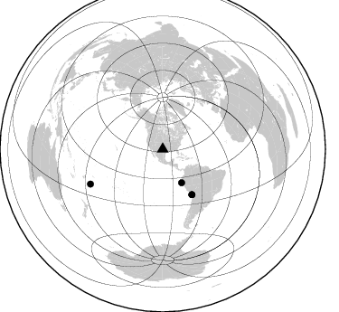
Nearby stations (2 deg radius)
| Station | Name | (Lat, Lon) | Start / End | Elevation |
| C0275 | 991022 | (32.85, -100.48) | 2014-03-07 / 2014-05-01 | 567 m |
| Crust2 Type: | D8,thick Platform 3 km seds. |
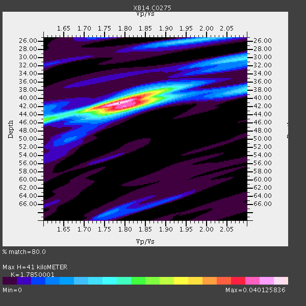
| Thickness Estimate: | 41 km |
| Thickness StdDev: | 2.8 km |
| Vp/Vs Estimate: | 1.79 |
| Vp/Vs StdDev: | 0.04 |
| Vs Estimate: | 3.6 km/s |
| Poisson's Ratio: | 0.27 |
| Peak Value: | 0.04 |
| Assumed Vp: | 6.426 km/s |
| Ps Weight: | 0.33333334 |
| PpPs Weight: | 0.33333334 |
| PsPs Weight: | 0.33333328 |
| Residual Complexity: | 0.523 |
| Nearby stations H: | +- |
| (2.0 deg) Vp/Vs: | +- |
1 with match > 90% ( 4.5454545 %) and 4 with match > 80% ( 18.181818 %) out of 22.
Download stack as xyz text file.
Azimuth Distribution of Events:
Prior Results for this Station
| Study | Thickness | Vp/Vs | Vp | Vs | Poissons Ratio | Extra |
| EARS | 41 km | 1.79 | 6.426 km/s | 3.6 km/s | 0.27 | |
| Crust2.0 | 46 km | 1.78 | 6.426 km/s | 3.613 km/s | 0.27 | D8,thick Platform 3 km seds. |
| Global Maxima | 41 km | 1.79 | 6.426 km/s | 3.6 km/s | 0.27 | amp=0.040125836 |
| Local Maxima 1 | 42 km | 1.81 | 6.426 km/s | 3.56 km/s | 0.28 | amp=0.023980513 |
| Local Maxima 2 | 38 km | 1.86 | 6.426 km/s | 3.45 km/s | 0.30 | amp=0.016106915 |
| Local Maxima 3 | 26 km | 1.96 | 6.426 km/s | 3.279 km/s | 0.32 | amp=0.012970013 |
| Local Maxima 4 | 45 km | 1.60 | 6.426 km/s | 4.016 km/s | 0.18 | amp=0.012263619 |
| Predicted Arrivals for vertical incidence (zero ray parameter) | |
| Ps | 5.01 SECOND |
| PpPs | 17.77 SECOND |
| PsPs/PpSs | 22.78 SECOND |
Events Processed for this Station
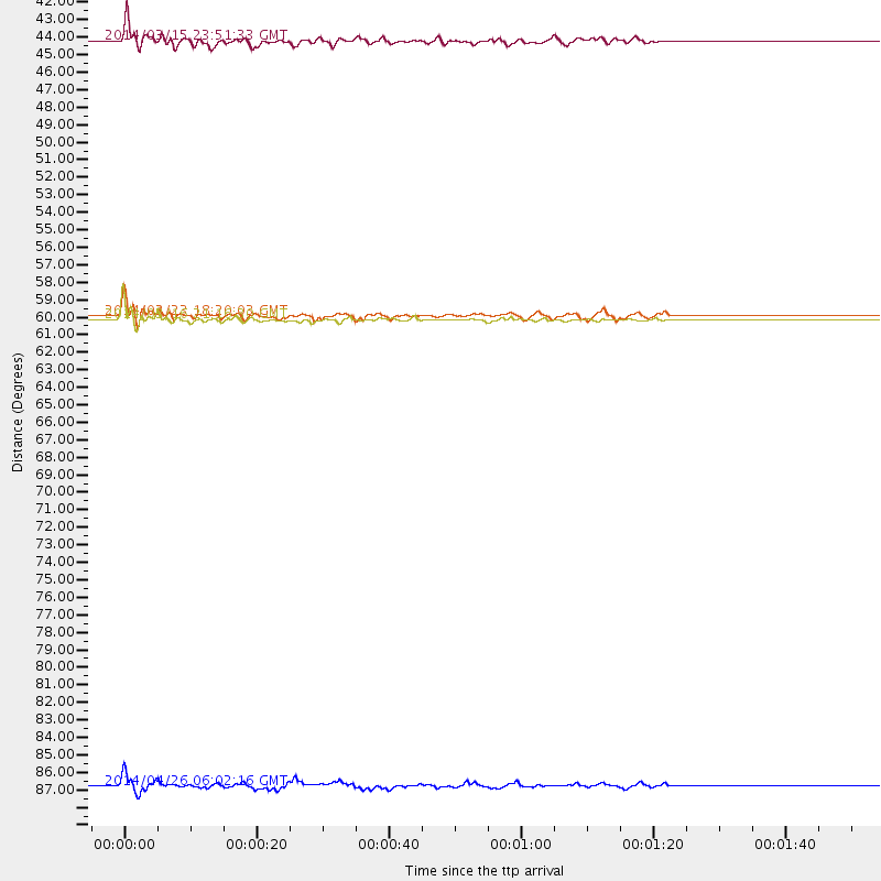
Download zip of receiver functions as SAC
Plot maxima for each earthquake.
Events Used in the Stack
(4 events)| Radial Match | Distance | Baz | FERegion | Time | Lat/Lon | Depth | Magnitude |
| 90.77125 | 59.7 deg | 147.163 deg | Near Coast Of Northern Chile | 2014/03/16 21:16:30 GMT | (-19.9, -70.6) | 20 km | 6.7 MWW, 6.7 MWC, 7.0 MI |
| 88.25274 | 42.5 deg | 150.491 deg | Near Coast Of Northern Peru | 2014/03/15 23:51:33 GMT | (-5.6, -81.0) | 29 km | 6.3 MWW, 6.2 MWB, 6.3 MWC |
| 85.88463 | 88.6 deg | 244.289 deg | Tonga Islands | 2014/04/26 06:02:16 GMT | (-20.7, -174.7) | 10 km | 6.5 MWP |
| 81.00217 | 59.5 deg | 147.236 deg | Near Coast Of Northern Chile | 2014/03/23 18:20:03 GMT | (-19.7, -70.8) | 35 km | 6.0 MB, 6.2 MWB, 6.2 MWW, 6.3 MWC |
Losers
(18 events)| Radial Match | Distance | Baz | FERegion | Time | Lat/Lon | Depth | Magnitude | Reason |
| 98.75132 | 59.4 deg | 147.185 deg | Near Coast Of Northern Chile | 2014/04/01 23:46:46 GMT | (-19.6, -70.8) | 20 km | 8.2 MWW, 8.0 MI, 8.1 MWC | |
| 97.32187 | 60.3 deg | 147.37 deg | Near Coast Of Northern Chile | 2014/04/03 02:43:14 GMT | (-20.5, -70.5) | 31 km | 7.7 MWW, 7.4 MI, 7.7 MWC | |
| 90.67922 | 60.3 deg | 147.655 deg | Near Coast Of Northern Chile | 2014/04/04 01:37:51 GMT | (-20.6, -70.7) | 20 km | 6.1 MWP, 6.1 MWB, 6.1 MWW, 6.3 MWC | |
| 81.67671 | 60.3 deg | 147.656 deg | Near Coast Of Northern Chile | 2014/04/03 03:11:14 GMT | (-20.6, -70.7) | 10 km | 5.8 MB | |
| 79.43651 | 60.1 deg | 147.286 deg | Near Coast Of Northern Chile | 2014/04/03 01:58:31 GMT | (-20.3, -70.6) | 23 km | 6.5 MWW, 6.5 MWB, 6.6 MWC | |
| 77.00234 | 59.5 deg | 146.854 deg | Near Coast Of Northern Chile | 2014/04/02 00:04:54 GMT | (-19.6, -70.5) | 34 km | 5.5 MB | |
| 76.12533 | 59.8 deg | 147.52 deg | Near Coast Of Northern Chile | 2014/04/07 13:43:20 GMT | (-20.2, -70.9) | 7.9 km | 5.8 MWB, 5.7 MWW, 5.7 MWC | |
| 73.2042 | 59.6 deg | 147.353 deg | Near Coast Of Northern Chile | 2014/04/02 00:03:12 GMT | (-19.8, -70.9) | 10 km | 5.8 MB | |
| 70.74961 | 59.4 deg | 147.165 deg | Near Coast Of Northern Chile | 2014/03/24 15:45:31 GMT | (-19.6, -70.8) | 18 km | 5.6 MWB, 5.5 MWR, 5.7 MWC, 5.7 MWW | |
| 70.27289 | 59.6 deg | 146.479 deg | Near Coast Of Northern Chile | 2014/04/01 23:59:57 GMT | (-19.5, -70.2) | 22 km | 5.8 MB | |
| 69.532936 | 52.1 deg | 149.762 deg | Near Coast Of Peru | 2014/03/15 08:59:21 GMT | (-14.1, -76.3) | 20 km | 6.1 MWW, 6.0 MWB, 6.2 MWC | |
| 64.49708 | 70.1 deg | 144.819 deg | Santiago Del Estero Prov., Arg. | 2014/04/18 07:46:57 GMT | (-27.7, -62.8) | 610 km | 5.6 MW | |
| 63.547504 | 49.5 deg | 333.689 deg | Northern Alaska | 2014/04/18 18:56:47 GMT | (67.7, -162.5) | 17 km | 5.7 MW | |
| 63.231636 | 49.5 deg | 333.644 deg | Northern Alaska | 2014/04/18 18:44:17 GMT | (67.7, -162.5) | 1.0 km | 5.5 MB, 5.4 MI | |
| 62.770447 | 60.0 deg | 147.757 deg | Near Coast Of Northern Chile | 2014/04/06 14:06:09 GMT | (-20.4, -71.0) | 20 km | 5.3 MW | |
| 59.882267 | 73.0 deg | 319.366 deg | Kuril Islands | 2014/04/07 09:34:49 GMT | (50.4, 156.3) | 85 km | 5.2 MW | |
| 50.29746 | 96.2 deg | 243.054 deg | South Of Fiji Islands | 2014/03/26 03:29:36 GMT | (-26.1, 179.3) | 493 km | 6.5 MWP, 6.3 MWW, 6.3 MWC, 6.4 MWB, 6.4 MWC, 6.5 MI | |
| 44.417652 | 33.9 deg | 125.293 deg | Venezuela | 2014/03/14 23:26:35 GMT | (10.3, -73.0) | 131 km | 5.0 MW |

