
Station XB C0299 - 991003
Network: XB14 - Sweetwater Array
Nearby stations (2 deg radius)
| Station | Name | (Lat, Lon) | Start / End | Elevation |
| C0299 | 991003 | (32.79, -100.63) | 2014-03-07 / 2014-12-31 | 638 m |
| Crust2 Type: | D8,thick Platform 3 km seds. |
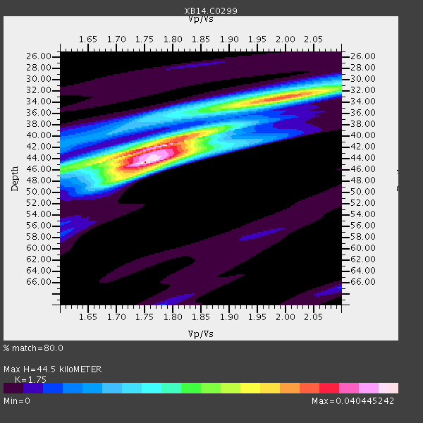
| Thickness Estimate: | 44 km |
| Thickness StdDev: | 2.4 km |
| Vp/Vs Estimate: | 1.75 |
| Vp/Vs StdDev: | 0.05 |
| Vs Estimate: | 3.672 km/s |
| Poisson's Ratio: | 0.26 |
| Peak Value: | 0.04 |
| Assumed Vp: | 6.426 km/s |
| Ps Weight: | 0.33333334 |
| PpPs Weight: | 0.33333334 |
| PsPs Weight: | 0.33333328 |
| Residual Complexity: | 0.720 |
| Nearby stations H: | +- |
| (2.0 deg) Vp/Vs: | +- |
2 with match > 90% ( 9.523809 %) and 8 with match > 80% ( 38.095238 %) out of 21.
Download stack as xyz text file.
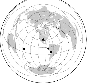
Azimuth Distribution of Events:
Prior Results for this Station
| Study | Thickness | Vp/Vs | Vp | Vs | Poissons Ratio | Extra |
| EARS | 44 km | 1.75 | 6.426 km/s | 3.672 km/s | 0.26 | |
| Crust2.0 | 46 km | 1.78 | 6.426 km/s | 3.613 km/s | 0.27 | D8,thick Platform 3 km seds. |
| Global Maxima | 44 km | 1.75 | 6.426 km/s | 3.672 km/s | 0.26 | amp=0.040445242 |
| Local Maxima 1 | 42 km | 1.79 | 6.426 km/s | 3.595 km/s | 0.27 | amp=0.032083247 |
| Local Maxima 2 | 33 km | 2.00 | 6.426 km/s | 3.213 km/s | 0.33 | amp=0.025892485 |
| Local Maxima 3 | 46 km | 1.60 | 6.426 km/s | 4.01 km/s | 0.18 | amp=0.016889466 |
| Local Maxima 4 | 32 km | 2.05 | 6.426 km/s | 3.135 km/s | 0.34 | amp=0.011249067 |
| Predicted Arrivals for vertical incidence (zero ray parameter) | |
| Ps | 5.19 SECOND |
| PpPs | 19.04 SECOND |
| PsPs/PpSs | 24.24 SECOND |
Events Processed for this Station
Download zip of receiver functions as SAC
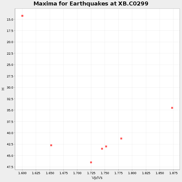
Plot maxima for each earthquake.
Events Used in the Stack
(8 events)| Radial Match | Distance | Baz | FERegion | Time | Lat/Lon | Depth | Magnitude |
| 93.78685 | 59.8 deg | 147.001 deg | Near Coast Of Northern Chile | 2014/03/16 21:16:30 GMT | (-19.9, -70.6) | 20 km | 6.7 MWW, 6.7 MWC, 7.0 MI |
| 91.05019 | 42.5 deg | 150.259 deg | Near Coast Of Northern Peru | 2014/03/15 23:51:33 GMT | (-5.6, -81.0) | 29 km | 6.3 MWW, 6.2 MWB, 6.3 MWC |
| 88.00269 | 59.8 deg | 147.359 deg | Near Coast Of Northern Chile | 2014/04/07 13:43:20 GMT | (-20.2, -70.9) | 7.9 km | 5.8 MWB, 5.7 MWW, 5.7 MWC |
| 87.167595 | 59.7 deg | 147.171 deg | Near Coast Of Northern Chile | 2014/03/18 21:26:45 GMT | (-20.0, -70.8) | 3.8 km | 5.8 MWW, 5.9 MWC, 6.0 MWR, 6.0 MWB |
| 87.0643 | 60.3 deg | 147.496 deg | Near Coast Of Northern Chile | 2014/04/04 01:37:51 GMT | (-20.6, -70.7) | 20 km | 6.1 MWP, 6.1 MWB, 6.1 MWW, 6.3 MWC |
| 86.91764 | 88.4 deg | 244.209 deg | Tonga Islands | 2014/04/26 06:02:16 GMT | (-20.7, -174.7) | 10 km | 6.5 MWP |
| 84.61295 | 60.1 deg | 147.126 deg | Near Coast Of Northern Chile | 2014/04/03 01:58:31 GMT | (-20.3, -70.6) | 23 km | 6.5 MWW, 6.5 MWB, 6.6 MWC |
| 82.45911 | 59.5 deg | 147.074 deg | Near Coast Of Northern Chile | 2014/03/23 18:20:03 GMT | (-19.7, -70.8) | 35 km | 6.0 MB, 6.2 MWB, 6.2 MWW, 6.3 MWC |
Losers
(13 events)| Radial Match | Distance | Baz | FERegion | Time | Lat/Lon | Depth | Magnitude | Reason |
| 98.68526 | 59.4 deg | 147.023 deg | Near Coast Of Northern Chile | 2014/04/01 23:46:46 GMT | (-19.6, -70.8) | 20 km | 8.2 MWW, 8.0 MI, 8.1 MWC | |
| 70.11233 | 52.1 deg | 149.573 deg | Near Coast Of Peru | 2014/03/15 08:59:21 GMT | (-14.1, -76.3) | 20 km | 6.1 MWW, 6.0 MWB, 6.2 MWC | |
| 68.49622 | 60.1 deg | 145.399 deg | Northern Chile | 2014/03/31 12:53:05 GMT | (-19.5, -69.2) | 112 km | 5.6 MB, 5.5 MWB, 5.6 MWC, 5.6 MWW | |
| 61.931576 | 60.6 deg | 147.262 deg | Near Coast Of Northern Chile | 2014/04/03 05:51:44 GMT | (-20.8, -70.4) | 27 km | 5.5 MB, 5.3 MWR | |
| 61.4906 | 59.6 deg | 146.318 deg | Near Coast Of Northern Chile | 2014/04/01 23:59:57 GMT | (-19.5, -70.2) | 22 km | 5.8 MB | |
| 60.285774 | 49.5 deg | 333.682 deg | Northern Alaska | 2014/04/18 18:44:17 GMT | (67.7, -162.5) | 1.0 km | 5.5 MB, 5.4 MI | |
| 59.121906 | 60.3 deg | 147.472 deg | Near Coast Of Northern Chile | 2014/04/13 12:11:30 GMT | (-20.6, -70.7) | 13 km | 5.5 MWW, 5.3 MWR | |
| 59.06053 | 89.8 deg | 314.26 deg | Near East Coast Of Honshu, Japan | 2014/03/29 01:53:57 GMT | (36.3, 141.8) | 20 km | 5.5 MWC, 5.4 MWB, 5.5 MWC | |
| 58.779793 | 93.2 deg | 41.266 deg | Southern Greece | 2014/04/04 20:08:07 GMT | (37.2, 23.8) | 107 km | 5.5 MWB, 5.5 MWR, 5.6 MWC, 5.6 MWW | |
| 57.76611 | 59.4 deg | 147.002 deg | Near Coast Of Northern Chile | 2014/03/24 15:45:31 GMT | (-19.6, -70.8) | 18 km | 5.6 MWB, 5.5 MWR, 5.7 MWC, 5.7 MWW | |
| 56.84685 | 60.4 deg | 147.551 deg | Near Coast Of Northern Chile | 2014/04/11 00:01:44 GMT | (-20.7, -70.7) | 18 km | 6.0 MB | |
| 53.286793 | 96.1 deg | 242.974 deg | South Of Fiji Islands | 2014/03/26 03:29:36 GMT | (-26.1, 179.3) | 493 km | 6.5 MWP, 6.3 MWW, 6.3 MWC, 6.4 MWB, 6.4 MWC, 6.5 MI | |
| 46.417747 | 60.1 deg | 147.604 deg | Near Coast Of Northern Chile | 2014/04/08 10:14:32 GMT | (-20.5, -70.9) | 7.1 km | 5.7 MWB, 5.5 MWR, 5.6 MWC, 5.6 MWW |

