
Station XB C0301 - 991004
Network: XB14 - Sweetwater Array
Nearby stations (2 deg radius)
| Station | Name | (Lat, Lon) | Start / End | Elevation |
| C0301 | 991004 | (32.64, -100.54) | 2014-03-07 / 2014-05-01 | 619 m |
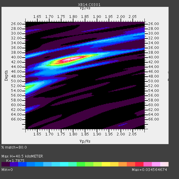
| Crust2 Type: | D8,thick Platform 3 km seds. |
| Thickness Estimate: | 40 km |
| Thickness StdDev: | 2.9 km |
| Vp/Vs Estimate: | 1.79 |
| Vp/Vs StdDev: | 0.05 |
| Vs Estimate: | 3.595 km/s |
| Poisson's Ratio: | 0.27 |
| Peak Value: | 0.03 |
| Assumed Vp: | 6.426 km/s |
| Ps Weight: | 0.33333334 |
| PpPs Weight: | 0.33333334 |
| PsPs Weight: | 0.33333328 |
| Residual Complexity: | 0.467 |
| Nearby stations H: | +- |
| (2.0 deg) Vp/Vs: | +- |
2 with match > 90% ( 6.6666665 %) and 6 with match > 80% ( 20.0 %) out of 30.
Download stack as xyz text file.
Azimuth Distribution of Events:

Prior Results for this Station
| Study | Thickness | Vp/Vs | Vp | Vs | Poissons Ratio | Extra |
| EARS | 40 km | 1.79 | 6.426 km/s | 3.595 km/s | 0.27 | |
| Crust2.0 | 46 km | 1.78 | 6.426 km/s | 3.613 km/s | 0.27 | D8,thick Platform 3 km seds. |
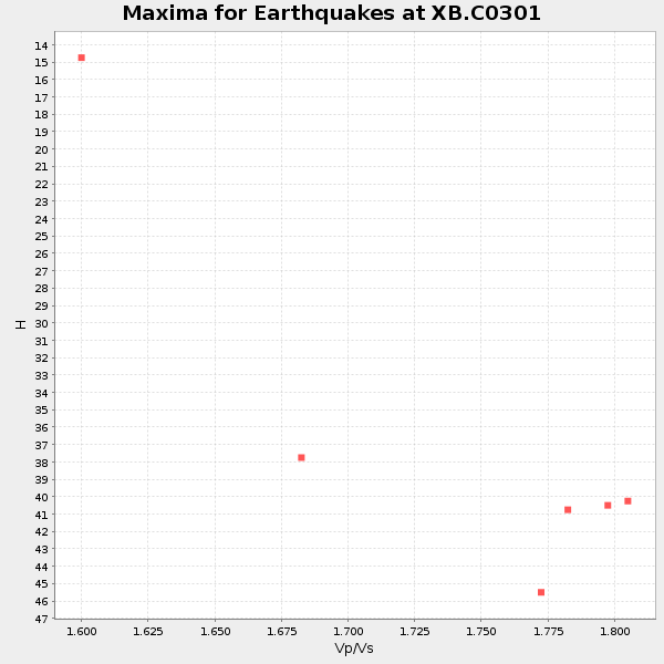
| Global Maxima | 40 km | 1.79 | 6.426 km/s | 3.595 km/s | 0.27 | amp=0.034564674 |
| Local Maxima 1 | 52 km | 1.60 | 6.426 km/s | 4.016 km/s | 0.18 | amp=0.01818491 |
| Local Maxima 2 | 42 km | 1.75 | 6.426 km/s | 3.667 km/s | 0.26 | amp=0.012586703 |
| Local Maxima 3 | 39 km | 1.62 | 6.426 km/s | 3.955 km/s | 0.20 | amp=0.009966079 |
| Local Maxima 4 | 54 km | 1.60 | 6.426 km/s | 4.016 km/s | 0.18 | amp=0.009022713 |
| Predicted Arrivals for vertical incidence (zero ray parameter) | |
| Ps | 4.96 SECOND |
| PpPs | 17.57 SECOND |
| PsPs/PpSs | 22.53 SECOND |
Events Processed for this Station
Download zip of receiver functions as SAC
Plot maxima for each earthquake.
Events Used in the Stack
(6 events)| Radial Match | Distance | Baz | FERegion | Time | Lat/Lon | Depth | Magnitude |
| 93.20035 | 59.6 deg | 147.038 deg | Near Coast Of Northern Chile | 2014/03/16 21:16:30 GMT | (-19.9, -70.6) | 20 km | 6.7 MWW, 6.7 MWC, 7.0 MI |
| 93.008316 | 59.3 deg | 147.181 deg | Near Coast Of Northern Chile | 2014/03/22 12:59:59 GMT | (-19.8, -70.9) | 20 km | 6.2 MWW, 6.2 MWB, 6.3 MWC, 6.4 MWC |
| 87.97755 | 42.3 deg | 150.296 deg | Near Coast Of Northern Peru | 2014/03/15 23:51:33 GMT | (-5.6, -81.0) | 29 km | 6.3 MWW, 6.2 MWB, 6.3 MWC |
| 82.84291 | 59.3 deg | 147.11 deg | Near Coast Of Northern Chile | 2014/03/23 18:20:03 GMT | (-19.7, -70.8) | 35 km | 6.0 MB, 6.2 MWB, 6.2 MWW, 6.3 MWC |
| 82.3554 | 59.7 deg | 147.395 deg | Near Coast Of Northern Chile | 2014/04/07 13:43:20 GMT | (-20.2, -70.9) | 7.9 km | 5.8 MWB, 5.7 MWW, 5.7 MWC |
| 81.30566 | 88.4 deg | 244.26 deg | Tonga Islands | 2014/04/26 06:02:16 GMT | (-20.7, -174.7) | 10 km | 6.5 MWP |
Losers
(24 events)| Radial Match | Distance | Baz | FERegion | Time | Lat/Lon | Depth | Magnitude | Reason |
| 98.80632 | 59.3 deg | 147.059 deg | Near Coast Of Northern Chile | 2014/04/01 23:46:46 GMT | (-19.6, -70.8) | 20 km | 8.2 MWW, 8.0 MI, 8.1 MWC | |
| 96.72872 | 60.2 deg | 147.247 deg | Near Coast Of Northern Chile | 2014/04/03 02:43:14 GMT | (-20.5, -70.5) | 31 km | 7.7 MWW, 7.4 MI, 7.7 MWC | |
| 84.75758 | 60.1 deg | 147.533 deg | Near Coast Of Northern Chile | 2014/04/04 01:37:51 GMT | (-20.6, -70.7) | 20 km | 6.1 MWP, 6.1 MWB, 6.1 MWW, 6.3 MWC | |
| 79.52137 | 59.9 deg | 147.162 deg | Near Coast Of Northern Chile | 2014/04/03 01:58:31 GMT | (-20.3, -70.6) | 23 km | 6.5 MWW, 6.5 MWB, 6.6 MWC | |
| 76.586235 | 60.1 deg | 147.501 deg | Near Coast Of Northern Chile | 2014/04/03 04:17:57 GMT | (-20.6, -70.7) | 18 km | 5.2 mb | |
| 75.9655 | 88.4 deg | 324.765 deg | E. Russia-N.E. China Border Reg. | 2014/04/12 21:22:44 GMT | (44.9, 133.7) | 10 km | 4.3 mb | |
| 75.303986 | 51.9 deg | 149.611 deg | Near Coast Of Peru | 2014/03/15 08:59:21 GMT | (-14.1, -76.3) | 20 km | 6.1 MWW, 6.0 MWB, 6.2 MWC | |
| 73.41487 | 60.2 deg | 147.534 deg | Near Coast Of Northern Chile | 2014/04/03 03:11:14 GMT | (-20.6, -70.7) | 10 km | 5.8 MB | |
| 69.1775 | 59.4 deg | 146.727 deg | Near Coast Of Northern Chile | 2014/04/02 00:04:54 GMT | (-19.6, -70.5) | 34 km | 5.5 MB | |
| 68.36193 | 89.8 deg | 248.443 deg | Fiji Islands Region | 2014/04/03 12:56:36 GMT | (-18.0, -178.4) | 579 km | 5.3 mb | |
| 66.25473 | 59.8 deg | 147.293 deg | Near Coast Of Northern Chile | 2014/04/15 16:21:17 GMT | (-20.2, -70.7) | 18 km | 5.1 MW | |
| 65.98314 | 60.4 deg | 147.298 deg | Near Coast Of Northern Chile | 2014/04/03 05:51:44 GMT | (-20.8, -70.4) | 27 km | 5.5 MB, 5.3 MWR | |
| 65.13041 | 59.5 deg | 147.389 deg | Near Coast Of Northern Chile | 2014/04/02 11:07:33 GMT | (-20.0, -71.0) | 27 km | 5.4 Mww | |
| 64.93745 | 49.6 deg | 333.728 deg | Northern Alaska | 2014/04/18 18:44:17 GMT | (67.7, -162.5) | 1.0 km | 5.5 MB, 5.4 MI | |
| 64.71997 | 90.4 deg | 242.426 deg | Tonga Islands Region | 2014/03/14 22:49:56 GMT | (-23.4, -175.3) | 14 km | 5.1 MW | |
| 64.244316 | 59.4 deg | 147.203 deg | Near Coast Of Northern Chile | 2014/03/22 13:14:55 GMT | (-19.8, -70.9) | 4.6 km | 5.2 Mww | |
| 60.31605 | 59.9 deg | 145.433 deg | Northern Chile | 2014/03/31 12:53:05 GMT | (-19.5, -69.2) | 112 km | 5.6 MB, 5.5 MWB, 5.6 MWC, 5.6 MWW | |
| 60.04165 | 70.6 deg | 154.379 deg | Near Coast Of Central Chile | 2014/04/05 02:22:38 GMT | (-32.8, -71.6) | 40 km | 5.6 MWC, 5.6 MWC | |
| 58.2788 | 59.6 deg | 147.208 deg | Near Coast Of Northern Chile | 2014/03/18 21:26:45 GMT | (-20.0, -70.8) | 3.8 km | 5.8 MWW, 5.9 MWC, 6.0 MWR, 6.0 MWB | |
| 52.592747 | 59.9 deg | 147.634 deg | Near Coast Of Northern Chile | 2014/04/06 14:06:09 GMT | (-20.4, -71.0) | 20 km | 5.3 MW | |
| 52.553524 | 59.4 deg | 146.353 deg | Near Coast Of Northern Chile | 2014/04/01 23:59:57 GMT | (-19.5, -70.2) | 22 km | 5.8 MB | |
| 51.63544 | 96.1 deg | 243.004 deg | South Of Fiji Islands | 2014/03/26 03:29:36 GMT | (-26.1, 179.3) | 493 km | 6.5 MWP, 6.3 MWW, 6.3 MWC, 6.4 MWB, 6.4 MWC, 6.5 MI | |
| 51.340004 | 73.1 deg | 319.385 deg | Kuril Islands | 2014/04/07 09:34:49 GMT | (50.4, 156.3) | 85 km | 5.2 MW | |
| 49.062397 | 69.9 deg | 144.726 deg | Santiago Del Estero Prov., Arg. | 2014/04/18 07:46:57 GMT | (-27.7, -62.8) | 610 km | 5.6 MW |

