
Station XB C0305 - 991016
Network: XB14 - Sweetwater Array
Nearby stations (2 deg radius)
| Station | Name | (Lat, Lon) | Start / End | Elevation |
| C0305 | 991016 | (32.73, -100.48) | 2014-03-07 / 2014-05-01 | 609 m |
| Crust2 Type: | D8,thick Platform 3 km seds. |
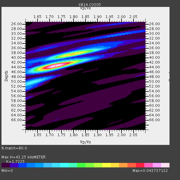
| Thickness Estimate: | 43 km |
| Thickness StdDev: | 2.0 km |
| Vp/Vs Estimate: | 1.72 |
| Vp/Vs StdDev: | 0.03 |
| Vs Estimate: | 3.731 km/s |
| Poisson's Ratio: | 0.25 |
| Peak Value: | 0.04 |
| Assumed Vp: | 6.426 km/s |
| Ps Weight: | 0.33333334 |
| PpPs Weight: | 0.33333334 |
| PsPs Weight: | 0.33333328 |
| Residual Complexity: | 0.434 |
| Nearby stations H: | 42 km +- 0.7 km |
| (2.0 deg) Vp/Vs: | 1.73 +- 0.00 |
1 with match > 90% ( 3.2258065 %) and 5 with match > 80% ( 16.129032 %) out of 31.
Download stack as xyz text file.
Azimuth Distribution of Events:

Prior Results for this Station
| Study | Thickness | Vp/Vs | Vp | Vs | Poissons Ratio | Extra |
| EARS | 43 km | 1.72 | 6.426 km/s | 3.731 km/s | 0.25 | |
| Crust2.0 | 46 km | 1.78 | 6.426 km/s | 3.613 km/s | 0.27 | D8,thick Platform 3 km seds. |
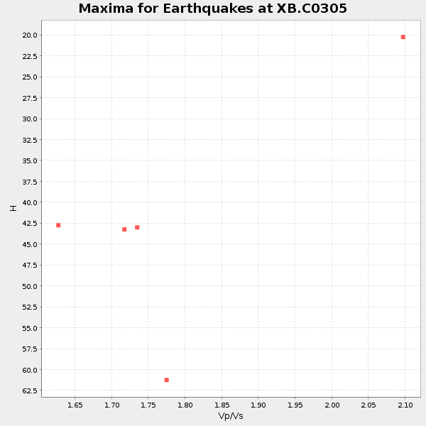
| Global Maxima | 43 km | 1.72 | 6.426 km/s | 3.731 km/s | 0.25 | amp=0.043737132 |
| Local Maxima 1 | 38 km | 1.80 | 6.426 km/s | 3.565 km/s | 0.28 | amp=0.023816047 |
| Local Maxima 2 | 43 km | 1.71 | 6.426 km/s | 3.769 km/s | 0.24 | amp=0.008622793 |
| Local Maxima 3 | 50 km | 1.61 | 6.426 km/s | 3.985 km/s | 0.19 | amp=0.0059888796 |
| Local Maxima 4 | 30 km | 1.98 | 6.426 km/s | 3.25 km/s | 0.33 | amp=0.005273327 |
| Predicted Arrivals for vertical incidence (zero ray parameter) | |
| Ps | 4.86 SECOND |
| PpPs | 18.32 SECOND |
| PsPs/PpSs | 23.19 SECOND |
Events Processed for this Station
Download zip of receiver functions as SAC
Plot maxima for each earthquake.
Events Used in the Stack
(5 events)| Radial Match | Distance | Baz | FERegion | Time | Lat/Lon | Depth | Magnitude |
| 93.65741 | 59.6 deg | 147.128 deg | Near Coast Of Northern Chile | 2014/03/16 21:16:30 GMT | (-19.9, -70.6) | 20 km | 6.7 MWW, 6.7 MWC, 7.0 MI |
| 88.6789 | 42.4 deg | 150.431 deg | Near Coast Of Northern Peru | 2014/03/15 23:51:33 GMT | (-5.6, -81.0) | 29 km | 6.3 MWW, 6.2 MWB, 6.3 MWC |
| 87.16597 | 88.5 deg | 244.294 deg | Tonga Islands | 2014/04/26 06:02:16 GMT | (-20.7, -174.7) | 10 km | 6.5 MWP |
| 84.29057 | 60.0 deg | 147.252 deg | Near Coast Of Northern Chile | 2014/04/03 01:58:31 GMT | (-20.3, -70.6) | 23 km | 6.5 MWW, 6.5 MWB, 6.6 MWC |
| 81.63648 | 59.4 deg | 147.201 deg | Near Coast Of Northern Chile | 2014/03/23 18:20:03 GMT | (-19.7, -70.8) | 35 km | 6.0 MB, 6.2 MWB, 6.2 MWW, 6.3 MWC |
Losers
(26 events)| Radial Match | Distance | Baz | FERegion | Time | Lat/Lon | Depth | Magnitude | Reason |
| 99.228455 | 59.3 deg | 147.15 deg | Near Coast Of Northern Chile | 2014/04/01 23:46:46 GMT | (-19.6, -70.8) | 20 km | 8.2 MWW, 8.0 MI, 8.1 MWC | |
| 96.56528 | 60.2 deg | 147.336 deg | Near Coast Of Northern Chile | 2014/04/03 02:43:14 GMT | (-20.5, -70.5) | 31 km | 7.7 MWW, 7.4 MI, 7.7 MWC | |
| 84.77116 | 60.2 deg | 147.622 deg | Near Coast Of Northern Chile | 2014/04/04 01:37:51 GMT | (-20.6, -70.7) | 20 km | 6.1 MWP, 6.1 MWB, 6.1 MWW, 6.3 MWC | |
| 84.40153 | 60.5 deg | 147.387 deg | Near Coast Of Northern Chile | 2014/04/03 05:51:44 GMT | (-20.8, -70.4) | 27 km | 5.5 MB, 5.3 MWR | |
| 77.27995 | 60.2 deg | 147.623 deg | Near Coast Of Northern Chile | 2014/04/03 03:11:14 GMT | (-20.6, -70.7) | 10 km | 5.8 MB | |
| 73.94277 | 59.6 deg | 147.298 deg | Near Coast Of Northern Chile | 2014/03/18 21:26:45 GMT | (-20.0, -70.8) | 3.8 km | 5.8 MWW, 5.9 MWC, 6.0 MWR, 6.0 MWB | |
| 73.2688 | 60.2 deg | 147.59 deg | Near Coast Of Northern Chile | 2014/04/03 04:17:57 GMT | (-20.6, -70.7) | 18 km | 5.2 mb | |
| 70.98202 | 52.0 deg | 149.719 deg | Near Coast Of Peru | 2014/03/15 08:59:21 GMT | (-14.1, -76.3) | 20 km | 6.1 MWW, 6.0 MWB, 6.2 MWC | |
| 70.35746 | 60.3 deg | 147.677 deg | Near Coast Of Northern Chile | 2014/04/11 00:01:44 GMT | (-20.7, -70.7) | 18 km | 6.0 MB | |
| 66.923485 | 59.7 deg | 147.486 deg | Near Coast Of Northern Chile | 2014/04/07 13:43:20 GMT | (-20.2, -70.9) | 7.9 km | 5.8 MWB, 5.7 MWW, 5.7 MWC | |
| 63.467773 | 96.1 deg | 243.045 deg | South Of Fiji Islands | 2014/03/26 03:29:36 GMT | (-26.1, 179.3) | 493 km | 6.5 MWP, 6.3 MWW, 6.3 MWC, 6.4 MWB, 6.4 MWC, 6.5 MI | |
| 62.064526 | 59.9 deg | 147.724 deg | Near Coast Of Northern Chile | 2014/04/06 14:06:09 GMT | (-20.4, -71.0) | 20 km | 5.3 MW | |
| 60.00028 | 59.5 deg | 146.444 deg | Near Coast Of Northern Chile | 2014/04/01 23:59:57 GMT | (-19.5, -70.2) | 22 km | 5.8 MB | |
| 59.686077 | 49.6 deg | 333.735 deg | Northern Alaska | 2014/04/18 18:56:47 GMT | (67.7, -162.5) | 17 km | 5.7 MW | |
| 59.217983 | 73.1 deg | 319.392 deg | Kuril Islands | 2014/04/07 09:34:49 GMT | (50.4, 156.3) | 85 km | 5.2 MW | |
| 59.014244 | 49.6 deg | 333.689 deg | Northern Alaska | 2014/04/18 18:44:17 GMT | (67.7, -162.5) | 1.0 km | 5.5 MB, 5.4 MI | |
| 56.748703 | 86.7 deg | 244.743 deg | Tonga Islands | 2014/04/06 08:14:00 GMT | (-19.3, -173.4) | 25 km | 5.1 MW | |
| 56.219513 | 60.0 deg | 145.523 deg | Northern Chile | 2014/03/31 12:53:05 GMT | (-19.5, -69.2) | 112 km | 5.6 MB, 5.5 MWB, 5.6 MWC, 5.6 MWW | |
| 55.697094 | 89.8 deg | 248.48 deg | Fiji Islands Region | 2014/04/03 12:56:36 GMT | (-18.0, -178.4) | 579 km | 5.3 mb | |
| 55.185688 | 60.0 deg | 147.731 deg | Near Coast Of Northern Chile | 2014/04/08 10:14:32 GMT | (-20.5, -70.9) | 7.1 km | 5.7 MWB, 5.5 MWR, 5.6 MWC, 5.6 MWW | |
| 54.326862 | 70.0 deg | 144.797 deg | Santiago Del Estero Prov., Arg. | 2014/04/18 07:46:57 GMT | (-27.7, -62.8) | 610 km | 5.6 MW | |
| 54.06015 | 59.8 deg | 147.383 deg | Near Coast Of Northern Chile | 2014/04/15 16:21:17 GMT | (-20.2, -70.7) | 18 km | 5.1 MW | |
| 53.135536 | 59.3 deg | 147.13 deg | Near Coast Of Northern Chile | 2014/03/24 15:45:31 GMT | (-19.6, -70.8) | 18 km | 5.6 MWB, 5.5 MWR, 5.7 MWC, 5.7 MWW | |
| 52.724796 | 70.6 deg | 154.446 deg | Near Coast Of Central Chile | 2014/04/05 02:22:38 GMT | (-32.8, -71.6) | 40 km | 5.6 MWC, 5.6 MWC | |
| 50.497814 | 88.1 deg | 316.525 deg | Eastern Honshu, Japan | 2014/04/02 23:22:47 GMT | (39.2, 141.8) | 56 km | 5.6 MB, 5.5 MWC | |
| 47.982605 | 63.8 deg | 148.063 deg | Northern Chile | 2014/03/20 18:41:32 GMT | (-24.0, -69.2) | 96 km | 5.1 MW |

