
Station XB C0312 - 991024
Network: XB14 - Sweetwater Array
Nearby stations (2 deg radius)
| Station | Name | (Lat, Lon) | Start / End | Elevation |
| C0312 | 991024 | (32.83, -100.41) | 2014-03-07 / 2014-12-31 | 591 m |
| Crust2 Type: | D8,thick Platform 3 km seds. |
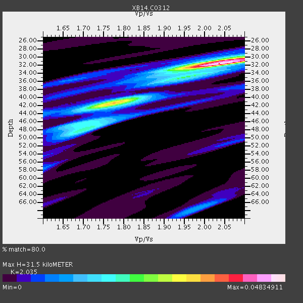
| Thickness Estimate: | 32 km |
| Thickness StdDev: | 3.8 km |
| Vp/Vs Estimate: | 2.04 |
| Vp/Vs StdDev: | 0.10 |
| Vs Estimate: | 3.158 km/s |
| Poisson's Ratio: | 0.34 |
| Peak Value: | 0.05 |
| Assumed Vp: | 6.426 km/s |
| Ps Weight: | 0.33333334 |
| PpPs Weight: | 0.33333334 |
| PsPs Weight: | 0.33333328 |
| Residual Complexity: | 0.586 |
| Nearby stations H: | +- |
| (2.0 deg) Vp/Vs: | +- |
3 with match > 90% ( 13.636364 %) and 7 with match > 80% ( 31.818182 %) out of 22.
Download stack as xyz text file.
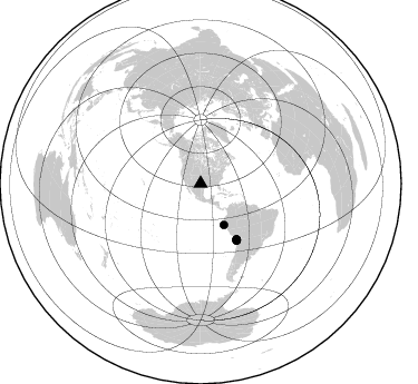
Azimuth Distribution of Events:
Prior Results for this Station
| Study | Thickness | Vp/Vs | Vp | Vs | Poissons Ratio | Extra |
| EARS | 32 km | 2.04 | 6.426 km/s | 3.158 km/s | 0.34 | |
| Crust2.0 | 46 km | 1.78 | 6.426 km/s | 3.613 km/s | 0.27 | D8,thick Platform 3 km seds. |
| Global Maxima | 32 km | 2.04 | 6.426 km/s | 3.158 km/s | 0.34 | amp=0.04834911 |
| Local Maxima 1 | 42 km | 1.76 | 6.426 km/s | 3.646 km/s | 0.26 | amp=0.027526833 |
| Local Maxima 2 | 48 km | 1.71 | 6.426 km/s | 3.752 km/s | 0.24 | amp=0.017802581 |
| Local Maxima 3 | 68 km | 1.98 | 6.426 km/s | 3.25 km/s | 0.33 | amp=0.011998347 |
| Local Maxima 4 | 30 km | 2.06 | 6.426 km/s | 3.119 km/s | 0.35 | amp=0.011831678 |
| Predicted Arrivals for vertical incidence (zero ray parameter) | |
| Ps | 5.07 SECOND |
| PpPs | 14.88 SECOND |
| PsPs/PpSs | 19.95 SECOND |
Events Processed for this Station
Download zip of receiver functions as SAC
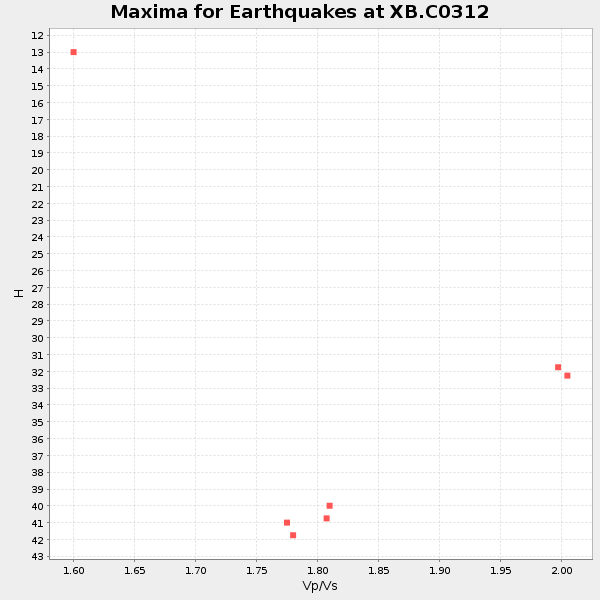
Plot maxima for each earthquake.
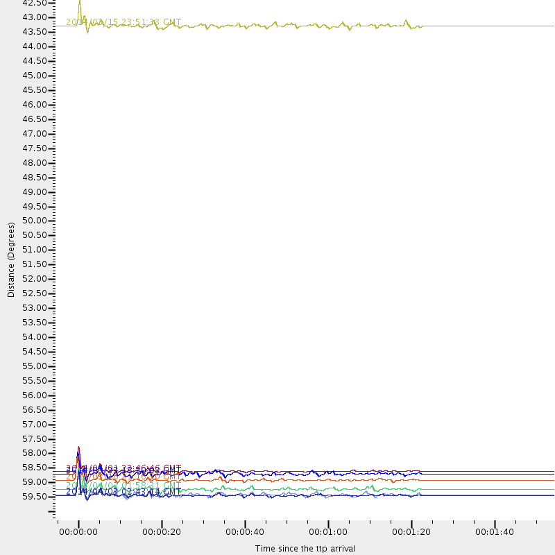
Events Used in the Stack
(7 events)| Radial Match | Distance | Baz | FERegion | Time | Lat/Lon | Depth | Magnitude |
| 99.05336 | 59.3 deg | 147.246 deg | Near Coast Of Northern Chile | 2014/04/01 23:46:46 GMT | (-19.6, -70.8) | 20 km | 8.2 MWW, 8.0 MI, 8.1 MWC |
| 97.21108 | 60.3 deg | 147.43 deg | Near Coast Of Northern Chile | 2014/04/03 02:43:14 GMT | (-20.5, -70.5) | 31 km | 7.7 MWW, 7.4 MI, 7.7 MWC |
| 95.18434 | 59.7 deg | 147.223 deg | Near Coast Of Northern Chile | 2014/03/16 21:16:30 GMT | (-19.9, -70.6) | 20 km | 6.7 MWW, 6.7 MWC, 7.0 MI |
| 88.69688 | 60.2 deg | 147.716 deg | Near Coast Of Northern Chile | 2014/04/04 01:37:51 GMT | (-20.6, -70.7) | 20 km | 6.1 MWP, 6.1 MWB, 6.1 MWW, 6.3 MWC |
| 83.61078 | 59.4 deg | 147.297 deg | Near Coast Of Northern Chile | 2014/03/23 18:20:03 GMT | (-19.7, -70.8) | 35 km | 6.0 MB, 6.2 MWB, 6.2 MWW, 6.3 MWC |
| 81.78097 | 42.4 deg | 150.574 deg | Near Coast Of Northern Peru | 2014/03/15 23:51:33 GMT | (-5.6, -81.0) | 29 km | 6.3 MWW, 6.2 MWB, 6.3 MWC |
| 80.58284 | 60.0 deg | 147.346 deg | Near Coast Of Northern Chile | 2014/04/03 01:58:31 GMT | (-20.3, -70.6) | 23 km | 6.5 MWW, 6.5 MWB, 6.6 MWC |
Losers
(15 events)| Radial Match | Distance | Baz | FERegion | Time | Lat/Lon | Depth | Magnitude | Reason |
| 86.32951 | 60.3 deg | 147.717 deg | Near Coast Of Northern Chile | 2014/04/03 03:11:14 GMT | (-20.6, -70.7) | 10 km | 5.8 MB | |
| 85.0737 | 88.6 deg | 244.329 deg | Tonga Islands | 2014/04/26 06:02:16 GMT | (-20.7, -174.7) | 10 km | 6.5 MWP | |
| 79.55256 | 52.0 deg | 149.832 deg | Near Coast Of Peru | 2014/03/15 08:59:21 GMT | (-14.1, -76.3) | 20 km | 6.1 MWW, 6.0 MWB, 6.2 MWC | |
| 72.981735 | 59.5 deg | 147.415 deg | Near Coast Of Northern Chile | 2014/04/02 00:03:12 GMT | (-19.8, -70.9) | 10 km | 5.8 MB | |
| 71.35021 | 59.8 deg | 147.581 deg | Near Coast Of Northern Chile | 2014/04/07 13:43:20 GMT | (-20.2, -70.9) | 7.9 km | 5.8 MWB, 5.7 MWW, 5.7 MWC | |
| 71.24389 | 59.5 deg | 146.54 deg | Near Coast Of Northern Chile | 2014/04/01 23:59:57 GMT | (-19.5, -70.2) | 22 km | 5.8 MB | |
| 70.880585 | 59.6 deg | 147.549 deg | Near Coast Of Northern Chile | 2014/04/19 20:54:42 GMT | (-20.0, -70.9) | 9.0 km | 5.8 MWR | |
| 65.07388 | 96.2 deg | 243.088 deg | South Of Fiji Islands | 2014/03/26 03:29:36 GMT | (-26.1, 179.3) | 493 km | 6.5 MWP, 6.3 MWW, 6.3 MWC, 6.4 MWB, 6.4 MWC, 6.5 MI | |
| 65.05906 | 59.6 deg | 147.393 deg | Near Coast Of Northern Chile | 2014/03/18 21:26:45 GMT | (-20.0, -70.8) | 3.8 km | 5.8 MWW, 5.9 MWC, 6.0 MWR, 6.0 MWB | |
| 63.768223 | 58.5 deg | 313.63 deg | Andreanof Islands, Aleutian Is. | 2014/03/13 13:20:59 GMT | (51.2, -179.1) | 26 km | 5.6 MWC, 5.1 ML, 5.4 MWW, 5.4 MWB, 5.5 ML, 5.6 MWC | |
| 63.14559 | 59.3 deg | 147.226 deg | Near Coast Of Northern Chile | 2014/03/24 15:45:31 GMT | (-19.6, -70.8) | 18 km | 5.6 MWB, 5.5 MWR, 5.7 MWC, 5.7 MWW | |
| 57.286335 | 49.5 deg | 333.645 deg | Northern Alaska | 2014/04/18 18:44:17 GMT | (67.7, -162.5) | 1.0 km | 5.5 MB, 5.4 MI | |
| 44.44548 | 60.0 deg | 145.619 deg | Northern Chile | 2014/03/31 12:53:05 GMT | (-19.5, -69.2) | 112 km | 5.6 MB, 5.5 MWB, 5.6 MWC, 5.6 MWW | |
| 36.968983 | 73.9 deg | 321.893 deg | Northwest Of Kuril Islands | 2014/03/12 18:18:40 GMT | (52.0, 153.2) | 418 km | 5.1 MW | |
| 26.714779 | 95.0 deg | 240.54 deg | Kermadec Islands Region | 2014/03/10 22:30:47 GMT | (-27.5, -178.0) | 150 km | 4.7 mb |

