
Station XB C0314 - 991008
Network: XB14 - Sweetwater Array
Nearby stations (2 deg radius)
| Station | Name | (Lat, Lon) | Start / End | Elevation |
| C0314 | 991008 | (32.73, -100.52) | 2014-03-07 / 2014-05-01 | 595 m |
| Crust2 Type: | D8,thick Platform 3 km seds. |
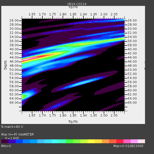
| Thickness Estimate: | 45 km |
| Thickness StdDev: | 8.5 km |
| Vp/Vs Estimate: | 1.61 |
| Vp/Vs StdDev: | 0.12 |
| Vs Estimate: | 4.004 km/s |
| Poisson's Ratio: | 0.18 |
| Peak Value: | 0.02 |
| Assumed Vp: | 6.426 km/s |
| Ps Weight: | 0.33333334 |
| PpPs Weight: | 0.33333334 |
| PsPs Weight: | 0.33333328 |
| Residual Complexity: | 0.770 |
| Nearby stations H: | +- |
| (2.0 deg) Vp/Vs: | +- |
2 with match > 90% ( 7.142857 %) and 4 with match > 80% ( 14.285714 %) out of 28.
Download stack as xyz text file.
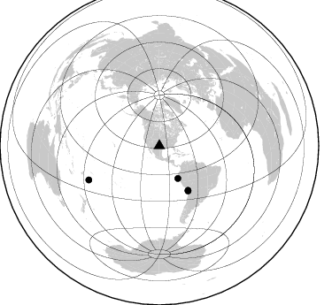
Azimuth Distribution of Events:
Prior Results for this Station
| Study | Thickness | Vp/Vs | Vp | Vs | Poissons Ratio | Extra |
| EARS | 45 km | 1.61 | 6.426 km/s | 4.004 km/s | 0.18 | |
| Crust2.0 | 46 km | 1.78 | 6.426 km/s | 3.613 km/s | 0.27 | D8,thick Platform 3 km seds. |
| Global Maxima | 45 km | 1.61 | 6.426 km/s | 4.004 km/s | 0.18 | amp=0.019823695 |
| Local Maxima 1 | 37 km | 1.88 | 6.426 km/s | 3.427 km/s | 0.30 | amp=0.011257915 |
| Local Maxima 2 | 63 km | 1.60 | 6.426 km/s | 4.016 km/s | 0.18 | amp=0.011130432 |
| Local Maxima 3 | 42 km | 1.73 | 6.426 km/s | 3.715 km/s | 0.25 | amp=0.009176576 |
| Local Maxima 4 | 34 km | 2.10 | 6.426 km/s | 3.064 km/s | 0.35 | amp=0.0070801834 |
| Predicted Arrivals for vertical incidence (zero ray parameter) | |
| Ps | 4.24 SECOND |
| PpPs | 18.24 SECOND |
| PsPs/PpSs | 22.48 SECOND |
Events Processed for this Station
Download zip of receiver functions as SAC
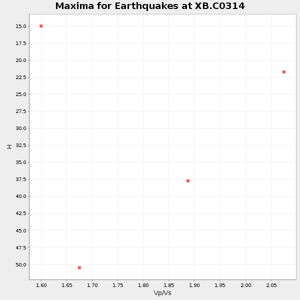
Plot maxima for each earthquake.
Events Used in the Stack
(4 events)| Radial Match | Distance | Baz | FERegion | Time | Lat/Lon | Depth | Magnitude |
| 93.14499 | 59.7 deg | 147.084 deg | Near Coast Of Northern Chile | 2014/03/16 21:16:30 GMT | (-19.9, -70.6) | 20 km | 6.7 MWW, 6.7 MWC, 7.0 MI |
| 92.08054 | 42.4 deg | 150.37 deg | Near Coast Of Northern Peru | 2014/03/15 23:51:33 GMT | (-5.6, -81.0) | 29 km | 6.3 MWW, 6.2 MWB, 6.3 MWC |
| 87.74612 | 60.2 deg | 147.578 deg | Near Coast Of Northern Chile | 2014/04/04 01:37:51 GMT | (-20.6, -70.7) | 20 km | 6.1 MWP, 6.1 MWB, 6.1 MWW, 6.3 MWC |
| 84.71806 | 88.5 deg | 244.268 deg | Tonga Islands | 2014/04/26 06:02:16 GMT | (-20.7, -174.7) | 10 km | 6.5 MWP |
Losers
(24 events)| Radial Match | Distance | Baz | FERegion | Time | Lat/Lon | Depth | Magnitude | Reason |
| 99.20926 | 59.3 deg | 147.106 deg | Near Coast Of Northern Chile | 2014/04/01 23:46:46 GMT | (-19.6, -70.8) | 20 km | 8.2 MWW, 8.0 MI, 8.1 MWC | |
| 97.430466 | 60.2 deg | 147.293 deg | Near Coast Of Northern Chile | 2014/04/03 02:43:14 GMT | (-20.5, -70.5) | 31 km | 7.7 MWW, 7.4 MI, 7.7 MWC | |
| 81.3682 | 60.5 deg | 147.343 deg | Near Coast Of Northern Chile | 2014/04/03 05:51:44 GMT | (-20.8, -70.4) | 27 km | 5.5 MB, 5.3 MWR | |
| 78.41861 | 59.8 deg | 147.442 deg | Near Coast Of Northern Chile | 2014/04/07 13:43:20 GMT | (-20.2, -70.9) | 7.9 km | 5.8 MWB, 5.7 MWW, 5.7 MWC | |
| 77.62321 | 59.4 deg | 147.157 deg | Near Coast Of Northern Chile | 2014/03/23 18:20:03 GMT | (-19.7, -70.8) | 35 km | 6.0 MB, 6.2 MWB, 6.2 MWW, 6.3 MWC | |
| 76.351364 | 60.3 deg | 147.634 deg | Near Coast Of Northern Chile | 2014/04/11 00:01:44 GMT | (-20.7, -70.7) | 18 km | 6.0 MB | |
| 76.23514 | 60.2 deg | 147.579 deg | Near Coast Of Northern Chile | 2014/04/03 03:11:14 GMT | (-20.6, -70.7) | 10 km | 5.8 MB | |
| 76.19481 | 60.0 deg | 147.208 deg | Near Coast Of Northern Chile | 2014/04/03 01:58:31 GMT | (-20.3, -70.6) | 23 km | 6.5 MWW, 6.5 MWB, 6.6 MWC | |
| 71.85568 | 52.0 deg | 149.668 deg | Near Coast Of Peru | 2014/03/15 08:59:21 GMT | (-14.1, -76.3) | 20 km | 6.1 MWW, 6.0 MWB, 6.2 MWC | |
| 67.04062 | 67.0 deg | 346.587 deg | Laptev Sea | 2014/04/11 13:27:05 GMT | (74.9, 133.8) | 10 km | 4.2 mb | |
| 65.97075 | 59.6 deg | 147.254 deg | Near Coast Of Northern Chile | 2014/03/18 21:26:45 GMT | (-20.0, -70.8) | 3.8 km | 5.8 MWW, 5.9 MWC, 6.0 MWR, 6.0 MWB | |
| 65.52114 | 60.0 deg | 145.48 deg | Northern Chile | 2014/03/31 12:53:05 GMT | (-19.5, -69.2) | 112 km | 5.6 MB, 5.5 MWB, 5.6 MWC, 5.6 MWW | |
| 64.72555 | 59.8 deg | 147.339 deg | Near Coast Of Northern Chile | 2014/04/15 16:21:17 GMT | (-20.2, -70.7) | 18 km | 5.1 MW | |
| 63.19697 | 86.7 deg | 244.715 deg | Tonga Islands | 2014/04/06 08:14:00 GMT | (-19.3, -173.4) | 25 km | 5.1 MW | |
| 62.22881 | 96.1 deg | 243.021 deg | South Of Fiji Islands | 2014/03/26 03:29:36 GMT | (-26.1, 179.3) | 493 km | 6.5 MWP, 6.3 MWW, 6.3 MWC, 6.4 MWB, 6.4 MWC, 6.5 MI | |
| 61.423462 | 73.9 deg | 321.869 deg | Northwest Of Kuril Islands | 2014/03/12 18:18:40 GMT | (52.0, 153.2) | 418 km | 5.1 MW | |
| 59.993088 | 70.0 deg | 144.76 deg | Santiago Del Estero Prov., Arg. | 2014/04/18 07:46:57 GMT | (-27.7, -62.8) | 610 km | 5.6 MW | |
| 59.689854 | 59.8 deg | 147.425 deg | Near Coast Of Northern Chile | 2014/04/02 04:46:18 GMT | (-20.2, -70.9) | 10 km | 5.8 MB | |
| 58.954487 | 59.5 deg | 146.4 deg | Near Coast Of Northern Chile | 2014/04/01 23:59:57 GMT | (-19.5, -70.2) | 22 km | 5.8 MB | |
| 58.68942 | 60.2 deg | 147.546 deg | Near Coast Of Northern Chile | 2014/04/03 04:17:57 GMT | (-20.6, -70.7) | 18 km | 5.2 mb | |
| 55.106552 | 49.6 deg | 333.737 deg | Northern Alaska | 2014/04/18 18:56:47 GMT | (67.7, -162.5) | 17 km | 5.7 MW | |
| 50.94438 | 73.1 deg | 319.374 deg | Kuril Islands | 2014/04/07 09:34:49 GMT | (50.4, 156.3) | 85 km | 5.2 MW | |
| 47.98138 | 94.5 deg | 239.729 deg | Kermadec Islands Region | 2014/03/19 16:00:23 GMT | (-27.9, -177.2) | 34 km | 5.7 MWB, 5.8 MWC, 5.8 MWW | |
| 46.367268 | 49.6 deg | 333.692 deg | Northern Alaska | 2014/04/18 18:44:17 GMT | (67.7, -162.5) | 1.0 km | 5.5 MB, 5.4 MI |

