
Station XB C0317 - 991014
Network: XB14 - Sweetwater Array
Nearby stations (2 deg radius)
| Station | Name | (Lat, Lon) | Start / End | Elevation |
| C0317 | 991014 | (32.77, -100.51) | 2014-03-07 / 2014-05-01 | 607 m |
| Crust2 Type: | D8,thick Platform 3 km seds. |
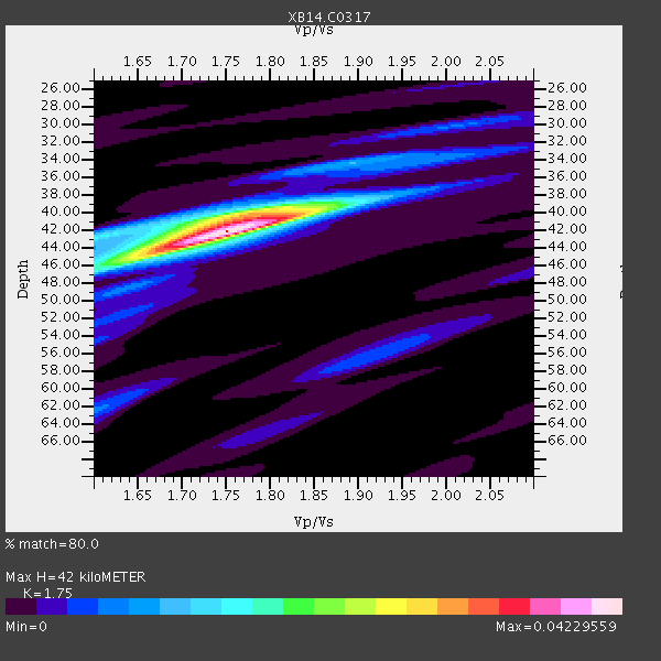
| Thickness Estimate: | 42 km |
| Thickness StdDev: | 1.1 km |
| Vp/Vs Estimate: | 1.75 |
| Vp/Vs StdDev: | 0.03 |
| Vs Estimate: | 3.672 km/s |
| Poisson's Ratio: | 0.26 |
| Peak Value: | 0.04 |
| Assumed Vp: | 6.426 km/s |
| Ps Weight: | 0.33333334 |
| PpPs Weight: | 0.33333334 |
| PsPs Weight: | 0.33333328 |
| Residual Complexity: | 0.468 |
| Nearby stations H: | 42 km +- 1.5 km |
| (2.0 deg) Vp/Vs: | 1.74 +- 0.04 |
1 with match > 90% ( 3.2258065 %) and 5 with match > 80% ( 16.129032 %) out of 31.
Download stack as xyz text file.
Azimuth Distribution of Events:

Prior Results for this Station
| Study | Thickness | Vp/Vs | Vp | Vs | Poissons Ratio | Extra |
| EARS | 42 km | 1.75 | 6.426 km/s | 3.672 km/s | 0.26 | |
| Crust2.0 | 46 km | 1.78 | 6.426 km/s | 3.613 km/s | 0.27 | D8,thick Platform 3 km seds. |
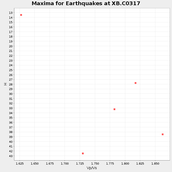
| Global Maxima | 42 km | 1.75 | 6.426 km/s | 3.672 km/s | 0.26 | amp=0.04229559 |
| Local Maxima 1 | 40 km | 1.79 | 6.426 km/s | 3.59 km/s | 0.27 | amp=0.02103294 |
| Local Maxima 2 | 45 km | 1.65 | 6.426 km/s | 3.895 km/s | 0.21 | amp=0.017034177 |
| Local Maxima 3 | 43 km | 1.60 | 6.426 km/s | 4.016 km/s | 0.18 | amp=0.009190389 |
| Local Maxima 4 | 62 km | 1.60 | 6.426 km/s | 4.016 km/s | 0.18 | amp=0.006901164 |
| Predicted Arrivals for vertical incidence (zero ray parameter) | |
| Ps | 4.90 SECOND |
| PpPs | 17.97 SECOND |
| PsPs/PpSs | 22.88 SECOND |
Events Processed for this Station
Download zip of receiver functions as SAC
Plot maxima for each earthquake.
Events Used in the Stack
(5 events)| Radial Match | Distance | Baz | FERegion | Time | Lat/Lon | Depth | Magnitude |
| 93.95347 | 59.7 deg | 147.111 deg | Near Coast Of Northern Chile | 2014/03/16 21:16:30 GMT | (-19.9, -70.6) | 20 km | 6.7 MWW, 6.7 MWC, 7.0 MI |
| 88.485435 | 88.5 deg | 244.276 deg | Tonga Islands | 2014/04/26 06:02:16 GMT | (-20.7, -174.7) | 10 km | 6.5 MWP |
| 86.234085 | 42.4 deg | 150.411 deg | Near Coast Of Northern Peru | 2014/03/15 23:51:33 GMT | (-5.6, -81.0) | 29 km | 6.3 MWW, 6.2 MWB, 6.3 MWC |
| 83.82633 | 59.4 deg | 147.184 deg | Near Coast Of Northern Chile | 2014/03/23 18:20:03 GMT | (-19.7, -70.8) | 35 km | 6.0 MB, 6.2 MWB, 6.2 MWW, 6.3 MWC |
| 81.397 | 60.2 deg | 147.604 deg | Near Coast Of Northern Chile | 2014/04/04 01:37:51 GMT | (-20.6, -70.7) | 20 km | 6.1 MWP, 6.1 MWB, 6.1 MWW, 6.3 MWC |
Losers
(26 events)| Radial Match | Distance | Baz | FERegion | Time | Lat/Lon | Depth | Magnitude | Reason |
| 99.00669 | 59.3 deg | 147.133 deg | Near Coast Of Northern Chile | 2014/04/01 23:46:46 GMT | (-19.6, -70.8) | 20 km | 8.2 MWW, 8.0 MI, 8.1 MWC | |
| 97.35856 | 60.3 deg | 147.319 deg | Near Coast Of Northern Chile | 2014/04/03 02:43:14 GMT | (-20.5, -70.5) | 31 km | 7.7 MWW, 7.4 MI, 7.7 MWC | |
| 77.73489 | 60.0 deg | 147.235 deg | Near Coast Of Northern Chile | 2014/04/03 01:58:31 GMT | (-20.3, -70.6) | 23 km | 6.5 MWW, 6.5 MWB, 6.6 MWC | |
| 75.6738 | 60.2 deg | 147.606 deg | Near Coast Of Northern Chile | 2014/04/03 03:11:14 GMT | (-20.6, -70.7) | 10 km | 5.8 MB | |
| 75.18793 | 60.5 deg | 147.37 deg | Near Coast Of Northern Chile | 2014/04/03 05:51:44 GMT | (-20.8, -70.4) | 27 km | 5.5 MB, 5.3 MWR | |
| 74.702774 | 59.6 deg | 147.281 deg | Near Coast Of Northern Chile | 2014/03/18 21:26:45 GMT | (-20.0, -70.8) | 3.8 km | 5.8 MWW, 5.9 MWC, 6.0 MWR, 6.0 MWB | |
| 74.039604 | 60.4 deg | 147.66 deg | Near Coast Of Northern Chile | 2014/04/11 00:01:44 GMT | (-20.7, -70.7) | 18 km | 6.0 MB | |
| 72.3018 | 59.8 deg | 147.468 deg | Near Coast Of Northern Chile | 2014/04/07 13:43:20 GMT | (-20.2, -70.9) | 7.9 km | 5.8 MWB, 5.7 MWW, 5.7 MWC | |
| 72.232445 | 59.3 deg | 147.116 deg | Near Coast Of Northern Chile | 2014/04/02 00:06:44 GMT | (-19.6, -70.8) | 10 km | 5.7 MB | |
| 70.099464 | 90.5 deg | 242.446 deg | Tonga Islands Region | 2014/03/14 22:49:56 GMT | (-23.4, -175.3) | 14 km | 5.1 MW | |
| 64.77663 | 60.0 deg | 147.706 deg | Near Coast Of Northern Chile | 2014/04/06 14:06:09 GMT | (-20.4, -71.0) | 20 km | 5.3 MW | |
| 64.34557 | 60.2 deg | 147.573 deg | Near Coast Of Northern Chile | 2014/04/03 04:17:57 GMT | (-20.6, -70.7) | 18 km | 5.2 mb | |
| 63.983818 | 49.5 deg | 333.677 deg | Northern Alaska | 2014/04/18 18:44:17 GMT | (67.7, -162.5) | 1.0 km | 5.5 MB, 5.4 MI | |
| 62.261143 | 96.1 deg | 243.033 deg | South Of Fiji Islands | 2014/03/26 03:29:36 GMT | (-26.1, 179.3) | 493 km | 6.5 MWP, 6.3 MWW, 6.3 MWC, 6.4 MWB, 6.4 MWC, 6.5 MI | |
| 61.215168 | 59.5 deg | 146.427 deg | Near Coast Of Northern Chile | 2014/04/01 23:59:57 GMT | (-19.5, -70.2) | 22 km | 5.8 MB | |
| 60.550507 | 60.0 deg | 145.507 deg | Northern Chile | 2014/03/31 12:53:05 GMT | (-19.5, -69.2) | 112 km | 5.6 MB, 5.5 MWB, 5.6 MWC, 5.6 MWW | |
| 59.971638 | 59.9 deg | 147.365 deg | Near Coast Of Northern Chile | 2014/04/15 16:21:17 GMT | (-20.2, -70.7) | 18 km | 5.1 MW | |
| 59.262955 | 97.6 deg | 318.252 deg | Kyushu, Japan | 2014/03/13 17:06:50 GMT | (33.7, 131.8) | 79 km | 6.3 MWW, 6.3 MWB, 6.3 MWC | |
| 56.876213 | 88.1 deg | 92.649 deg | North Of Ascension Island | 2014/04/30 15:52:42 GMT | (-1.2, -13.5) | 14 km | 5.8 MW | |
| 55.520386 | 73.1 deg | 319.373 deg | Kuril Islands | 2014/04/07 09:34:49 GMT | (50.4, 156.3) | 85 km | 5.2 MW | |
| 55.511635 | 67.0 deg | 346.587 deg | Laptev Sea | 2014/04/11 13:27:05 GMT | (74.9, 133.8) | 10 km | 4.2 mb | |
| 52.724968 | 88.0 deg | 316.508 deg | Eastern Honshu, Japan | 2014/04/02 23:22:47 GMT | (39.2, 141.8) | 56 km | 5.6 MB, 5.5 MWC | |
| 52.322083 | 70.0 deg | 144.78 deg | Santiago Del Estero Prov., Arg. | 2014/04/18 07:46:57 GMT | (-27.7, -62.8) | 610 km | 5.6 MW | |
| 51.58199 | 59.8 deg | 147.452 deg | Near Coast Of Northern Chile | 2014/04/02 04:46:18 GMT | (-20.2, -70.9) | 10 km | 5.8 MB | |
| 50.41987 | 49.5 deg | 333.722 deg | Northern Alaska | 2014/04/18 18:56:47 GMT | (67.7, -162.5) | 17 km | 5.7 MW | |
| 49.56595 | 63.9 deg | 148.046 deg | Northern Chile | 2014/03/20 18:41:32 GMT | (-24.0, -69.2) | 96 km | 5.1 MW |

