
Station XB C0324 - 991019
Network: XB14 - Sweetwater Array
Nearby stations (2 deg radius)
| Station | Name | (Lat, Lon) | Start / End | Elevation |
| C0324 | 991019 | (32.78, -100.48) | 2014-03-07 / 2014-05-01 | 580 m |
| Crust2 Type: | D8,thick Platform 3 km seds. |
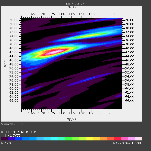
| Thickness Estimate: | 42 km |
| Thickness StdDev: | 1.3 km |
| Vp/Vs Estimate: | 1.77 |
| Vp/Vs StdDev: | 0.04 |
| Vs Estimate: | 3.636 km/s |
| Poisson's Ratio: | 0.26 |
| Peak Value: | 0.04 |
| Assumed Vp: | 6.426 km/s |
| Ps Weight: | 0.33333334 |
| PpPs Weight: | 0.33333334 |
| PsPs Weight: | 0.33333328 |
| Residual Complexity: | 0.542 |
| Nearby stations H: | +- |
| (2.0 deg) Vp/Vs: | +- |
1 with match > 90% ( 3.7037036 %) and 5 with match > 80% ( 18.518518 %) out of 27.
Download stack as xyz text file.
Azimuth Distribution of Events:
Prior Results for this Station
| Study | Thickness | Vp/Vs | Vp | Vs | Poissons Ratio | Extra |
| EARS | 42 km | 1.77 | 6.426 km/s | 3.636 km/s | 0.26 | |
| Crust2.0 | 46 km | 1.78 | 6.426 km/s | 3.613 km/s | 0.27 | D8,thick Platform 3 km seds. |
| Global Maxima | 42 km | 1.77 | 6.426 km/s | 3.636 km/s | 0.26 | amp=0.04285598 |
| Local Maxima 1 | 41 km | 1.73 | 6.426 km/s | 3.715 km/s | 0.25 | amp=0.023834854 |
| Local Maxima 2 | 33 km | 1.95 | 6.426 km/s | 3.304 km/s | 0.32 | amp=0.02087762 |
| Local Maxima 3 | 43 km | 1.75 | 6.426 km/s | 3.677 km/s | 0.26 | amp=0.014042602 |
| Local Maxima 4 | 33 km | 1.97 | 6.426 km/s | 3.258 km/s | 0.33 | amp=0.0061549186 |
| Predicted Arrivals for vertical incidence (zero ray parameter) | |
| Ps | 4.96 SECOND |
| PpPs | 17.87 SECOND |
| PsPs/PpSs | 22.83 SECOND |
Events Processed for this Station
Download zip of receiver functions as SAC
Plot maxima for each earthquake.
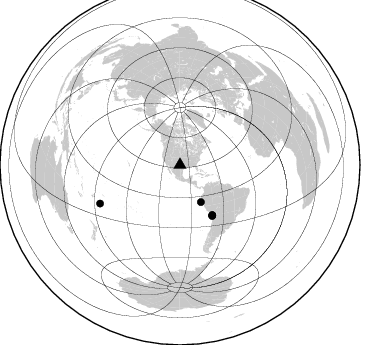
Events Used in the Stack
(5 events)| Radial Match | Distance | Baz | FERegion | Time | Lat/Lon | Depth | Magnitude |
| 94.321526 | 59.7 deg | 147.138 deg | Near Coast Of Northern Chile | 2014/03/16 21:16:30 GMT | (-19.9, -70.6) | 20 km | 6.7 MWW, 6.7 MWC, 7.0 MI |
| 88.84593 | 88.5 deg | 244.289 deg | Tonga Islands | 2014/04/26 06:02:16 GMT | (-20.7, -174.7) | 10 km | 6.5 MWP |
| 84.09834 | 60.2 deg | 147.631 deg | Near Coast Of Northern Chile | 2014/04/04 01:37:51 GMT | (-20.6, -70.7) | 20 km | 6.1 MWP, 6.1 MWB, 6.1 MWW, 6.3 MWC |
| 83.498085 | 42.4 deg | 150.451 deg | Near Coast Of Northern Peru | 2014/03/15 23:51:33 GMT | (-5.6, -81.0) | 29 km | 6.3 MWW, 6.2 MWB, 6.3 MWC |
| 82.1032 | 59.4 deg | 147.212 deg | Near Coast Of Northern Chile | 2014/03/23 18:20:03 GMT | (-19.7, -70.8) | 35 km | 6.0 MB, 6.2 MWB, 6.2 MWW, 6.3 MWC |
Losers
(22 events)| Radial Match | Distance | Baz | FERegion | Time | Lat/Lon | Depth | Magnitude | Reason |
| 98.931145 | 59.3 deg | 147.161 deg | Near Coast Of Northern Chile | 2014/04/01 23:46:46 GMT | (-19.6, -70.8) | 20 km | 8.2 MWW, 8.0 MI, 8.1 MWC | |
| 96.87755 | 60.3 deg | 147.346 deg | Near Coast Of Northern Chile | 2014/04/03 02:43:14 GMT | (-20.5, -70.5) | 31 km | 7.7 MWW, 7.4 MI, 7.7 MWC | |
| 79.36886 | 60.0 deg | 147.262 deg | Near Coast Of Northern Chile | 2014/04/03 01:58:31 GMT | (-20.3, -70.6) | 23 km | 6.5 MWW, 6.5 MWB, 6.6 MWC | |
| 78.67667 | 60.2 deg | 147.6 deg | Near Coast Of Northern Chile | 2014/04/03 04:17:57 GMT | (-20.6, -70.7) | 18 km | 5.2 mb | |
| 78.35171 | 60.2 deg | 147.633 deg | Near Coast Of Northern Chile | 2014/04/03 03:11:14 GMT | (-20.6, -70.7) | 10 km | 5.8 MB | |
| 76.842896 | 60.4 deg | 147.687 deg | Near Coast Of Northern Chile | 2014/04/11 00:01:44 GMT | (-20.7, -70.7) | 18 km | 6.0 MB | |
| 73.84918 | 59.8 deg | 147.496 deg | Near Coast Of Northern Chile | 2014/04/07 13:43:20 GMT | (-20.2, -70.9) | 7.9 km | 5.8 MWB, 5.7 MWW, 5.7 MWC | |
| 70.353004 | 87.2 deg | 243.87 deg | Tonga Islands | 2014/04/21 13:37:14 GMT | (-20.2, -173.2) | 47 km | 5.0 MW | |
| 70.33295 | 60.0 deg | 147.733 deg | Near Coast Of Northern Chile | 2014/04/06 14:06:09 GMT | (-20.4, -71.0) | 20 km | 5.3 MW | |
| 69.59042 | 89.8 deg | 248.475 deg | Fiji Islands Region | 2014/04/03 12:56:36 GMT | (-18.0, -178.4) | 579 km | 5.3 mb | |
| 65.27614 | 59.5 deg | 146.455 deg | Near Coast Of Northern Chile | 2014/04/01 23:59:57 GMT | (-19.5, -70.2) | 22 km | 5.8 MB | |
| 64.664856 | 59.6 deg | 147.308 deg | Near Coast Of Northern Chile | 2014/03/18 21:26:45 GMT | (-20.0, -70.8) | 3.8 km | 5.8 MWW, 5.9 MWC, 6.0 MWR, 6.0 MWB | |
| 61.26166 | 59.3 deg | 147.14 deg | Near Coast Of Northern Chile | 2014/03/24 15:45:31 GMT | (-19.6, -70.8) | 18 km | 5.6 MWB, 5.5 MWR, 5.7 MWC, 5.7 MWW | |
| 61.206467 | 49.5 deg | 333.669 deg | Northern Alaska | 2014/04/18 18:44:17 GMT | (67.7, -162.5) | 1.0 km | 5.5 MB, 5.4 MI | |
| 61.11674 | 59.6 deg | 147.464 deg | Near Coast Of Northern Chile | 2014/04/19 20:54:42 GMT | (-20.0, -70.9) | 9.0 km | 5.8 MWR | |
| 57.961956 | 96.2 deg | 243.046 deg | South Of Fiji Islands | 2014/03/26 03:29:36 GMT | (-26.1, 179.3) | 493 km | 6.5 MWP, 6.3 MWW, 6.3 MWC, 6.4 MWB, 6.4 MWC, 6.5 MI | |
| 57.44819 | 59.5 deg | 147.213 deg | Near Coast Of Northern Chile | 2014/03/24 11:32:15 GMT | (-19.8, -70.8) | 24 km | 5.3 MW | |
| 53.13878 | 73.1 deg | 319.378 deg | Kuril Islands | 2014/04/07 09:34:49 GMT | (50.4, 156.3) | 85 km | 5.2 MW | |
| 51.835835 | 60.0 deg | 145.534 deg | Northern Chile | 2014/03/31 12:53:05 GMT | (-19.5, -69.2) | 112 km | 5.6 MB, 5.5 MWB, 5.6 MWC, 5.6 MWW | |
| 48.341827 | 49.5 deg | 333.714 deg | Northern Alaska | 2014/04/18 18:56:47 GMT | (67.7, -162.5) | 17 km | 5.7 MW | |
| 47.477993 | 59.8 deg | 147.479 deg | Near Coast Of Northern Chile | 2014/04/02 04:46:18 GMT | (-20.2, -70.9) | 10 km | 5.8 MB | |
| 41.78155 | 70.0 deg | 144.802 deg | Santiago Del Estero Prov., Arg. | 2014/04/18 07:46:57 GMT | (-27.7, -62.8) | 610 km | 5.6 MW |

