
Station XB C0325 - 991015
Network: XB14 - Sweetwater Array
Nearby stations (2 deg radius)
| Station | Name | (Lat, Lon) | Start / End | Elevation |
| C0325 | 991015 | (32.86, -100.54) | 2014-03-07 / 2014-05-01 | 611 m |
| Crust2 Type: | D8,thick Platform 3 km seds. |
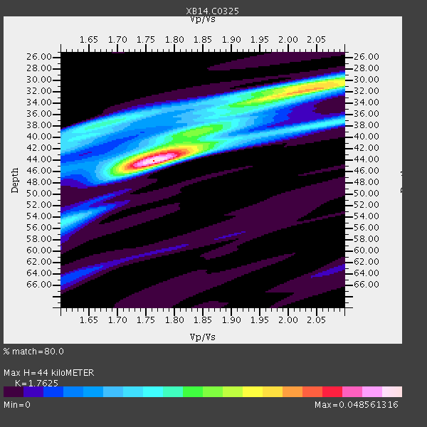
| Thickness Estimate: | 44 km |
| Thickness StdDev: | 5.3 km |
| Vp/Vs Estimate: | 1.76 |
| Vp/Vs StdDev: | 0.11 |
| Vs Estimate: | 3.646 km/s |
| Poisson's Ratio: | 0.26 |
| Peak Value: | 0.05 |
| Assumed Vp: | 6.426 km/s |
| Ps Weight: | 0.33333334 |
| PpPs Weight: | 0.33333334 |
| PsPs Weight: | 0.33333328 |
| Residual Complexity: | 0.729 |
| Nearby stations H: | +- |
| (2.0 deg) Vp/Vs: | +- |
1 with match > 90% ( 3.5714285 %) and 3 with match > 80% ( 10.714286 %) out of 28.
Download stack as xyz text file.
Azimuth Distribution of Events:

Prior Results for this Station
| Study | Thickness | Vp/Vs | Vp | Vs | Poissons Ratio | Extra |
| EARS | 44 km | 1.76 | 6.426 km/s | 3.646 km/s | 0.26 | |
| Crust2.0 | 46 km | 1.78 | 6.426 km/s | 3.613 km/s | 0.27 | D8,thick Platform 3 km seds. |
| Global Maxima | 44 km | 1.76 | 6.426 km/s | 3.646 km/s | 0.26 | amp=0.048561316 |
| Local Maxima 1 | 32 km | 2.03 | 6.426 km/s | 3.169 km/s | 0.34 | amp=0.034141563 |
| Local Maxima 2 | 42 km | 1.80 | 6.426 km/s | 3.57 km/s | 0.28 | amp=0.024050586 |
| Local Maxima 3 | 38 km | 1.68 | 6.426 km/s | 3.836 km/s | 0.22 | amp=0.020558905 |
| Local Maxima 4 | 30 km | 2.06 | 6.426 km/s | 3.119 km/s | 0.35 | amp=0.018795634 |
| Predicted Arrivals for vertical incidence (zero ray parameter) | |
| Ps | 5.22 SECOND |
| PpPs | 18.92 SECOND |
| PsPs/PpSs | 24.14 SECOND |
Events Processed for this Station
Download zip of receiver functions as SAC
Plot maxima for each earthquake.
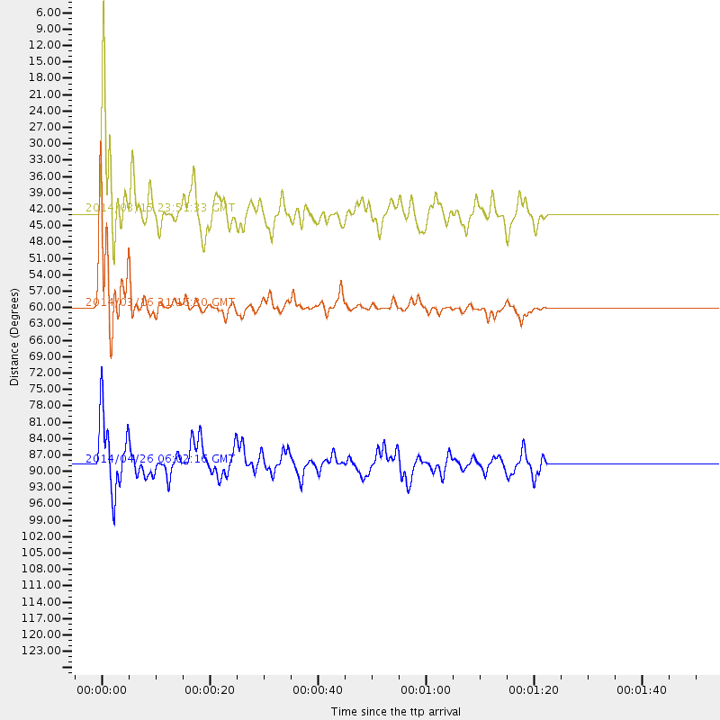
Events Used in the Stack
(3 events)| Radial Match | Distance | Baz | FERegion | Time | Lat/Lon | Depth | Magnitude |
| 92.85007 | 59.8 deg | 147.115 deg | Near Coast Of Northern Chile | 2014/03/16 21:16:30 GMT | (-19.9, -70.6) | 20 km | 6.7 MWW, 6.7 MWC, 7.0 MI |
| 89.24632 | 42.5 deg | 150.426 deg | Near Coast Of Northern Peru | 2014/03/15 23:51:33 GMT | (-5.6, -81.0) | 29 km | 6.3 MWW, 6.2 MWB, 6.3 MWC |
| 88.42284 | 88.5 deg | 244.259 deg | Tonga Islands | 2014/04/26 06:02:16 GMT | (-20.7, -174.7) | 10 km | 6.5 MWP |
Losers
(25 events)| Radial Match | Distance | Baz | FERegion | Time | Lat/Lon | Depth | Magnitude | Reason |
| 98.734085 | 59.4 deg | 147.138 deg | Near Coast Of Northern Chile | 2014/04/01 23:46:46 GMT | (-19.6, -70.8) | 20 km | 8.2 MWW, 8.0 MI, 8.1 MWC | |
| 97.262794 | 60.3 deg | 147.323 deg | Near Coast Of Northern Chile | 2014/04/03 02:43:14 GMT | (-20.5, -70.5) | 31 km | 7.7 MWW, 7.4 MI, 7.7 MWC | |
| 84.35864 | 60.3 deg | 147.608 deg | Near Coast Of Northern Chile | 2014/04/04 01:37:51 GMT | (-20.6, -70.7) | 20 km | 6.1 MWP, 6.1 MWB, 6.1 MWW, 6.3 MWC | |
| 79.11213 | 59.7 deg | 147.285 deg | Near Coast Of Northern Chile | 2014/03/18 21:26:45 GMT | (-20.0, -70.8) | 3.8 km | 5.8 MWW, 5.9 MWC, 6.0 MWR, 6.0 MWB | |
| 78.67031 | 60.4 deg | 147.663 deg | Near Coast Of Northern Chile | 2014/04/11 00:01:44 GMT | (-20.7, -70.7) | 18 km | 6.0 MB | |
| 77.52765 | 59.5 deg | 147.189 deg | Near Coast Of Northern Chile | 2014/03/23 18:20:03 GMT | (-19.7, -70.8) | 35 km | 6.0 MB, 6.2 MWB, 6.2 MWW, 6.3 MWC | |
| 77.26394 | 60.1 deg | 147.238 deg | Near Coast Of Northern Chile | 2014/04/03 01:58:31 GMT | (-20.3, -70.6) | 23 km | 6.5 MWW, 6.5 MWB, 6.6 MWC | |
| 71.37419 | 52.1 deg | 149.707 deg | Near Coast Of Peru | 2014/03/15 08:59:21 GMT | (-14.1, -76.3) | 20 km | 6.1 MWW, 6.0 MWB, 6.2 MWC | |
| 69.01911 | 59.9 deg | 147.472 deg | Near Coast Of Northern Chile | 2014/04/07 13:43:20 GMT | (-20.2, -70.9) | 7.9 km | 5.8 MWB, 5.7 MWW, 5.7 MWC | |
| 67.19357 | 59.6 deg | 146.432 deg | Near Coast Of Northern Chile | 2014/04/01 23:59:57 GMT | (-19.5, -70.2) | 22 km | 5.8 MB | |
| 66.219734 | 59.5 deg | 146.806 deg | Near Coast Of Northern Chile | 2014/04/02 00:04:54 GMT | (-19.6, -70.5) | 34 km | 5.5 MB | |
| 64.96952 | 49.4 deg | 333.689 deg | Northern Alaska | 2014/04/18 18:56:47 GMT | (67.7, -162.5) | 17 km | 5.7 MW | |
| 61.842728 | 96.2 deg | 243.028 deg | South Of Fiji Islands | 2014/03/26 03:29:36 GMT | (-26.1, 179.3) | 493 km | 6.5 MWP, 6.3 MWW, 6.3 MWC, 6.4 MWB, 6.4 MWC, 6.5 MI | |
| 61.279415 | 59.5 deg | 147.417 deg | Near Coast Of Northern Chile | 2014/04/02 04:19:48 GMT | (-19.9, -71.0) | 16 km | 5.1 mb | |
| 58.50728 | 59.6 deg | 147.244 deg | Near Coast Of Northern Chile | 2014/03/24 11:40:44 GMT | (-19.8, -70.8) | 23 km | 5.5 MB, 5.5 MWR, 5.6 MWW, 5.7 MWC | |
| 56.96939 | 59.4 deg | 147.117 deg | Near Coast Of Northern Chile | 2014/03/24 15:45:31 GMT | (-19.6, -70.8) | 18 km | 5.6 MWB, 5.5 MWR, 5.7 MWC, 5.7 MWW | |
| 55.56749 | 70.8 deg | 154.419 deg | Near Coast Of Central Chile | 2014/04/05 02:22:38 GMT | (-32.8, -71.6) | 40 km | 5.6 MWC, 5.6 MWC | |
| 53.877384 | 60.1 deg | 147.709 deg | Near Coast Of Northern Chile | 2014/04/06 14:06:09 GMT | (-20.4, -71.0) | 20 km | 5.3 MW | |
| 53.75498 | 60.0 deg | 147.369 deg | Near Coast Of Northern Chile | 2014/04/15 16:21:17 GMT | (-20.2, -70.7) | 18 km | 5.1 MW | |
| 52.38507 | 49.4 deg | 333.643 deg | Northern Alaska | 2014/04/18 18:44:17 GMT | (67.7, -162.5) | 1.0 km | 5.5 MB, 5.4 MI | |
| 51.48976 | 70.1 deg | 144.779 deg | Santiago Del Estero Prov., Arg. | 2014/04/18 07:46:57 GMT | (-27.7, -62.8) | 610 km | 5.6 MW | |
| 46.79676 | 60.1 deg | 145.512 deg | Northern Chile | 2014/03/31 12:53:05 GMT | (-19.5, -69.2) | 112 km | 5.6 MB, 5.5 MWB, 5.6 MWC, 5.6 MWW | |
| 46.053795 | 59.9 deg | 147.455 deg | Near Coast Of Northern Chile | 2014/04/02 04:46:18 GMT | (-20.2, -70.9) | 10 km | 5.8 MB | |
| 44.123703 | 63.6 deg | 317.559 deg | Near Islands, Aleutian Islands | 2014/04/07 07:48:29 GMT | (53.0, 171.0) | 26 km | 5.2 MW | |
| 42.40934 | 73.0 deg | 319.344 deg | Kuril Islands | 2014/04/07 09:34:49 GMT | (50.4, 156.3) | 85 km | 5.2 MW |

